
Chambers Pillar, NT
From gravity-defying boulders in the Red Centre to limestone spires and ancient volcanic domes, Australia’s iconic rock formations tell stories as old as time. Here are eight of our top picks (in no particular order) that are worth a visit.
1. Karlu Karlu / Devils Marbles, NT
It’s well worth getting out of bed early to watch the sunrise over Karlu Karlu / Devils Marbles, 100km south of Tennant Creek, just off the Stuart Highway.
Karlu Karlu is a sacred cultural landscape and the ancestral land of the Warumungu, Kaytetye, Alyawarr and Warlpiri peoples.
Karlu Karlu, meaning ‘round boulders’, is a striking collection of enormous, naturally rounded granite formations, some of which are seemingly precariously balanced on top of each other. These scattered clusters of ‘marbles’ are spread across the vast, shallow valley that forms the conservation reserve.
 Karlu Karlu / Devils Marbles, NT
The morning and evening sun highlights the deep red colour of the Karlu Karlu and makes for stunning pictures of this fascinating landscape.
If you’re visiting the NT you’ll need a Parks Pass to visit Devils Marbles Conservation Reserve and you can only do this online. Cost per day is $10 adults, $5 children or $25 a family. A two-week or open (12-month pass) might be better value for money if you want to keep exploring the NT. Camping and walking fees are payable on top of the visitor pass.
Getting there
Karlu Karlu / Devils Marbles Conservation Reserve is around 410km north of Alice Springs and 100km south of Tennant Creek, just off the sealed Stuart Highway. It is two-wheel drive friendly.
Where to stay
There is a simple bush campground with 24 sites. No power or water available and no generators or pets permitted. There is a drop toilet, some sheltered picnic tables and fireplaces with barbecue plates, but you’ll need to bring in your own wood.
Camping is $10 per adult per night and children over five years $5 per night. Again, all bookings must be made online as there are no services available on site.
There’s also a caravan park at the Wauchope Hotel and Roadhouse about 10km down the highway. Closer still is the Devils Marble Hotel on the Stuart Highway which has caravan and camping sites, rooms, a bar and meals.
What to do
There are a couple of scenic walks within the reserve. The Nyanjiki Lookout offers stunning panoramic views, while the Karlu Karlu Walk is a leisurely and flat 20-minute return stroll from the day-use car park, featuring informative signage about the formation of Karlu (marbles). If you’re feeling a bit more adventurous, the 4km Nurrku Walk is a great way to explore the broader reserve landscape.
You can also head into the Iytwelepenty / Davenport Ranges National Park and do a bit more 4WD exploring and learn about the mining and pastoral history of the region.
2. Wave Rock, WA
Resembling a monster wave breaking onto the land, Wave Rock outside Hyden is a popular destination for thousands of Western Australian travellers every year. The lower section of the hill — known as Hyden Rock — is a weather-worn 15m-tall granite cliff face that resembles a giant cresting wave, giving the landmark its name. The concave feature that runs 110m along the base of the rock is one of several inselbergs in the Wheatbelt region east of Perth.
Like other unique rock formations in this story, an inselberg, from the German ‘island mountain’, is an isolated rock structure that rises from a relatively flat landscape. It is thought that the chemical reaction of mineral-infused water flowing against the rock caused the erosion when Hyden Rock was still underground. Further erosion of the surrounding softer landscape delivered the unusual scene we see today.
 Wave Rock attracts thousands of visitors annually
Getting there
Wave Rock is located approximately 340km from Perth via the Brookton Highway and 195km from Ravensthorpe to the south. The nearest town is Hyden, 5km away. Entry is $12 per car.
Where to stay
Wave Rock Resort has a caravan park (Wave Rock Caravan Park), and there’s also the small council-run Hyden Lion’s Park in town and The Camp, located 1.5km outside Hyden. A day trip from Ravensthorpe is possible, and there are numerous options if you are exploring along the south coast.
What to do
Wave Rock is 100m from the car park along a well-formed path to the rock where you can walk under the length of the crest, taking in the size and wonder. The rock itself is formed from three granite domes, and the climb to the top of the main structure follows stairs and a gradual path with views of the surrounding area. A wall along the edge follows the contours of the slope, diverting water to the dam built in 1928. It also protects the unwary from a nasty fall. Weathered boulders in modern art forms make memorable photo opportunities, so take your time to wander.
 There are lots of photo opportunities at Hyden Rock, so take your camera
Other tracks lead around Hyden Rock and to the top. The 1220m Gnamma Trail features interpretive panels for indigenous rock holes and a lizard trap.
A short drive takes you to Mulka’s Cave, featuring numerous Aboriginal paintings, including ochre hand stencils on the walls. It takes a while to adjust to the gloomy interior, and more artwork gradually shows itself as your eyes adapt. The Wave Rock Resort has a cafe and Hyden offers cafes and a bakery.
 Aboriginal rock paintings in Mulka’s Cave
If the timetable suits a visit to coincide with wildflower season in late winter, early spring should be rewarding.
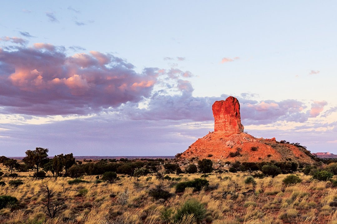
3. Chambers Pillar, NT
Located around 160km south of Alice Springs, Chambers Pillar is a 50m tall sandstone formation that rises from the Simpson Desert plain, forming the centrepiece of the Chambers Pillar Historical Reserve. The reserve is a great day or weekend trip destination from Alice Springs. The pillar is especially stunning at sunset, when its deep red and orange hues light up the desert.
Known as Itirkawarra to the Southern Arrernte (Pertame) Traditional Owners, Chambers Pillar and nearby formations — Window and Castle rocks — are important cultural sites and part of the local Dreamtime story of the gecko ancestor Itirkawarra.
First recorded by European explorers in 1860, the pillar was used as a navigation point for early explorers, settlers and builders of the Overland Telegraph Line, with many leaving their names or initials on the rock face — but please don’t be tempted to add your own.
 An aerial view of Castle Rock, Window Rock and Chambers Pillar
Getting there
The route to the reserve is mostly dirt or sand and requires a high clearance 4WD and an offroad-rated caravan or camper trailer. Road conditions can vary dramatically depending on recent weather. Expect deep sandy tracks, corrugations, bulldust ruts and creek crossings.
You can either follow the Old Stuart Highway from Alice Springs or go via the Hugh River Stock Route (camping available at Stuarts Well Roadhouse and Caravan Park). Allow at least three hours for the drive from Alice Springs. Stop in at Titjikala Community for fuel, supplies and to visit the art gallery.
Be prepared for sand driving — bring a sand flag, UHF radio and gear to adjust tyre pressure. A valid NT Parks Pass is also required. Check road conditions before you go.
 Road conditions can vary, so plan accordingly
Where to stay
The reserve has two campgrounds, both bookable online. Pillar Campground is closest to the pillar, while Bush Campground suits caravans and camper trailers, with views of all three rocks. Facilities include toilets, picnic areas, fire pits and barbecues — but no drinking water or bins, so come prepared and take rubbish with you.
The campgrounds can get busy during the cooler months and interstate school holidays, so arrive early to snag a spot with good views of the rocks.
What to do
There are plenty of short bushwalks around the reserve, with two official tracks. The main walk climbs and loops around Chambers Pillar and includes a viewing platform of the area and the carved names and initials and informative signage — allow around an hour to complete. The second track leads to Window and Castle rocks nearby — allow around half an hour.
 There are some famous, and not so famous names carved into the sandstone
Photography, birdwatching and stargazing are popular activities and spring brings desert wildflowers into bloom across the landscape.
4. Gulaga / Mount Dromedary, NSW
Gulaga / Mount Dromedary is one of the first Australian landscape features named by James Cook on his voyage up the New South Wales coast in April 1770. It is a significant creation site for local Yuin people and was handed back to Traditional Owners in 2006 as part of the Gulaga National Park. It’s now known by both its European and Yuin names. It rises from its base in the southern NSW village of Central Tilba to a height of 806m and is seen from Bermagui to Tuross Heads.
Approximately 94 million years ago, Gulaga was a 40sq km volcano, and what remains is the original, eroded core, classified as the Mount Dromedary/Gulaga Igneous Complex. Part of the mountain’s significance lies in the fields of rock formations near the summit, which helped Geoscience Australia list Gulaga among the top seven of Australia’s significant rock formations.
When I first saw these towering granite outcrops, they struck me with awe. Their other worldly impression was quite spooky, and the others who have been there have told me they felt the same.
It’s a full day out, so be sure to carry some water and a snack. Good shoes are essential
 Gulaga from the air at Narooma (Image Eurobodalla Shire Council)
Getting there
Central Tilba is 15km south of Narooma on the NSW South Coast. Either drive through Central Tilba or keep following the Princes Highway to the Tilba Tilba turnoff and follow the road north. The Mount Dromedary Trail starts next to Pam’s store.
An old fire trail leads near the summit, where a walking track takes you to the top. However, it’s a 5km walk to where a picnic table marks the side track to the formations and then 5km back to the car, so consider skipping the summit and head to Tilba Tilba for an ice cream instead.
Where to stay
Gulaga looks over the sparkling blue waters of both the Eurobodalla and Sapphire Coasts. So, check into the Reflections Bermagui Holiday Park about 15km away from Tilba Tilba or head up the road to Narooma. You might need a rest.
What to do
Take the Gulaga Mountain Track to the magnificent granite tors. It’s a trek, but it’s worth it to experience the spirit of the place. Then relax in the old-world atmosphere of Tilba Tilba, just a few minutes’ drive back towards Narooma.
 The view from the summit
5. The Southern and Western Lost Cities, NT
Rising from the red earth like the ruins of a forgotten world, the Southern and Western Lost Cities are among the Northern Territory’s most striking natural landmarks. Formed over 1500 million years, these towering sandstone structures were shaped by ancient seas, tectonic uplift and centuries of erosion — creating a surreal landscape of chasms, ridges and wind-carved spires.
The Southern Lost City is the more accessible of the two, with a well-marked 2.5km loop trail weaving through rock formations up to 25m high. Early morning or late afternoon is the best time to visit, when the sandstone glows with vivid reds and oranges.
For those seeking more adventure, the Western Lost City offers a wilder experience. It’s only accessible via a rough 28km 4WD track and has no facilities — but the remoteness adds to its appeal, with its leaning towers and dramatic outcrops offering a real sense of isolation.
 The Western Lost City, Limmen National Park, NT
Getting there
Limmen National Park is located about 305km southeast of Katherine or 76km northwest of Borroloola along the Savannah Way. It’s remote country, so come prepared with plenty of water and fuel. The Southern Lost City is 35km south of the Nathan River Ranger Station, with a turn-off leading to a car park and campground.
Roads are unsealed and often heavily corrugated, with occasional washouts. A high clearance 4WD is strongly recommended, and it’s essential to check conditions before travel (P: 08 8975 9940).
Access to the Western Lost City requires an entry code from the ranger station. The 28km 4WD access track is quite rough and includes creek crossings — leave the van behind and allow at least 1.5 hours each way.
A valid NT Parks Pass is required to enter the park — these can be purchased online before you go.
 The Southern Lost City is the more accessible of the two
Where to stay
The Southern Lost City campground is a short walk from the formations, with unpowered, caravan-friendly sites, toilets and fire pits. Dogs are not permitted.
There’s no camping at the Western Lost City. For nearby stays, consider Butterfly Falls, Munbililla (Tomato Island) or Limmen Bight River Fishing Camp.
 Campsites in the Southern Lost City must be pre-booked
What to do
Walk among the towering formations, enjoy four-wheel driving, bushwalks or try your luck fishing (be croc safe). With swimming holes, waterfalls and rich birdlife, Limmen is a remote paradise for those who come prepared.
6. The Pinnacles, WA
The other-worldly, lunar-like landscape of The Pinnacles at Nambung National Park is just a couple of hours’ drive north of Perth on the Coral Coast.
You can walk or drive the 4.5km through this sandy desert landscape in which thousands of huge limestone pillars — some 3.5m tall — rise to form this most unique rock collection. The Pinnacles were formed some 25,000–35,000 years ago when the ocean receded and left deposits of shells. Ocean winds blew away the surrounding sand over time, leaving the pillars exposed. Each pillar is different — some are jagged and pointy, others are smooth and mushroom shaped.
 The lunar-like landscape of The Pinnacles
If you drive, there are parking bay at various points along the way where you can stop and enjoy the Pinnacles on foot.
The park itself comprises 17,487 hectares and is home to a huge range of native animals and birds. There’s a terrific visitor information centre, toilets and places to have a picnic so you can easily make a day of it. No dogs are allowed, and WA Parks fees apply ($17 per vehicle or $10 concession).
Getting there
Nambung National Park is easily accessible for all vehicles on the sealed Indian Ocean Drive, about 190km north of Perth. The closest town for fuel and supplies is Cervantes.
 Each pillar has a different shape
Where to stay
There is an RAC Holiday Park at Cervantes, however we chose to drive about 40km inland to the Nambung Station Stay — a 2023 hectare working cattle farm that offers powered and unpowered caravan-friendly sites and a couple of onsite caravans in a beautiful rural setting at reasonable low rates.
What to do
As well as Nambung National Park, you can explore the Coral Coast townships of Cervantes and Jurian Bay or head to some of the other nearby national parks such as Lesueur National Park for bushwalking, bird watching and seasonal wildflowers.
7. Bungle Bungle Range, WA
It says a lot about our country that an incredible place like the 450sq km Bungle Bungle Range in Purnululu National Park wasn’t widely known to the outside world until 1982. Pastoralists were aware of it, but they largely kept it to themselves. For the Gija people, it was home forever, and for them ‘purnululu’ means sandstone. When word got out, things happened quickly, and by 1987, it had become a national park. In 2003, it was designated a World Heritage Area.
These days, it retains a mystique courtesy of its isolation and word about how rough the access road can be at times. The wet season closes it off between December and March, sometimes longer when the access track is impassable.
 The beehive shaped rock structures of Purnululu
Even so, thousands make the 53km journey into the national park along a dusty, corrugated track that can take up to two hours to complete.
The reward is a vast panorama of unique sandstone cliffs, narrow gorges, chasms, caves and soaring, banded beehive-shaped monoliths of spectacular natural beauty. According to the World Heritage criterion, these “dramatically sculptured structures are unrivalled in their scale, extent, grandeur and diversity of form anywhere in the world due to the unique confluence of natural forces over hundreds of millions of years”.
 Bird’s eye view of the Bungle Bungle Range
Getting there
Purnululu National Park is in the Kimberley region of northern Western Australia. The turnoff from the Great Northern Highway is 250km southwest of Kununurra or 108km northeast of Halls Creek. It is then a 53km single-lane track, suitable only for high-clearance 4WD vehicles. A single-axle offroad camper or van is permitted. Park entry is $17 ($10 concession) per vehicle. You can leave a larger van at a Kununurra Caravan Park, but you will need a tent and camping gear.
Where to stay
Because it’s at least half a day’s drive from anywhere, you need to camp for a couple of nights — at least — to make the most of the journey. There are two bush camps in the national park with a $15 per person, per night fee, and bookings are required. All sites are unpowered. No pets, no fires, no drinking water provided, no dump point. Pit toilet available.
What to do
Before you go, download the park and trail maps from the park’s website (see below).
Settle into a camp at either end of the park and check out the view of the range in the setting sun from a natural ridge to the west. Get an early start to beat the heat for your choice of walks, which can be up to 20km from camp.
In the northern end of the park, the Echidna Chasm Walk leads through a high gorge that is as narrow as one metre in places. Rock scrambles require agility. The sun is overhead around noon, and the play of light on the towering cliffs changes things dramatically. In the south, Cathedral Gorge is a 2km walk that opens out to a vast amphitheatre with a permanent pool of water. Piccaninny Gorge follows the creek bed through a picturesque set of domes, and if you are early enough in the season, there will still be water running.
 Stunning chasms
8. Kata Tjuta / Mount Olga, NT
Also known as the Olgas, Kata Tjuta — meaning ‘many heads’ in the Pitjantjatjara language — may take a backseat to its neighbour, Uluru. But to some, its many facets make it even more interesting, another memorable dimension to a visit to Australia’s red heart. The formations are weathered sedimentary conglomerates and the highest stands at 460m — more than 100m taller than Uluru. The 36 domes that comprise the formation are spread across the relatively flat, sandy landscape, and throughout the day and in different seasons, the colours change in mesmerising patterns. Guided tours and scenic flights are available.
You will need an Uluru-Kata Tjuta National Park pass (not the NT Parks Pass), which is available online for $38 for a three-day entry.
 Kata Tjuta means ‘many heads’
Getting there
Uluṟu-Kata Tjuṯa National Park is 447km from Alice Springs, accessible via sealed roads, and 247 km from Erldunda Roadhouse on the Lasseter Highway.
Where to stay
Camping is located in the Ayers Rock Campground (Ayers Rock Resort) in Yulara, and it’s a 50km drive to Kata Tjuta. Powered sites starting at $70 per night, with a minimum three-night booking requirement.
What to do
Visit the Uluṟu-Kata Tjuṯa Cultural Centre in Yulara to gain insights into local Anangu culture and the significance of Kata Tjuta in Aboriginal tradition. The centre features an Indigenous gallery, a cafe and a learning centre focused on traditional law.
 There’s a selection of walks through the domes
Drive to the Kata Tjuta car park and enjoy a selection of hikes through the domes. The Valley of the Winds circuit takes approximately four hours to complete, traversing steep, rocky terrain with two lookouts that offer views of the domes and the unique countryside.
The Walpa Gorge Walk is a relatively easy track through the steep walls of the domes.
Sunrise and sunset are popular times for photography, and dedicated viewing platforms can become crowded during peak times. However, there are many alternatives for wide-angle images.
Where to find these iconic rock formations:

THE NEXT STEP
If you want to learn the latest caravan news, find the most innovative new caravans and camping gear or get inspired to plan your next road trip adventure to some of Australia's best getaway destinations, subscribe to our weekly newsletter. We promise to send you only the best content.
Related articles:
Visiting Port Campbell along the Great Ocean Road, Vic


8 must-see rock formations to visit on your Big Lap