
The West Macs
AC journey through the Red Centre will leave the most well-read individuals feeling illiterate. The English language just doesn’t have enough words for ochre colours and their variants. At our disposal we’ve “red”, “orange”, “yellow”; the slightly more exotic “maroon”, “rusty orange” and “red-brown”; and, for those less conscious of sounding like tosspots, “vermillion”, “burnt umber” and “like the sole of my Louboutin’s”. “Wine red,” ventures Mum on her fourth glass, while “tangerine” and “mandarin” spring to the mind of the ever-alert Dad wandering the fruit aisle in Alice Springs’ Coles. Still, this arsenal falls short; but when you’re left speechless by a place, you know it’s worth it.
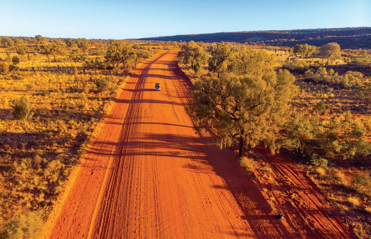
Any journey through the Red Centre is incomplete if it doesn’t include the West MacDonnell Ranges, also known as Tjoritja, accessible from Alice Springs via the attraction-crammed 370km loop formed by Namatjira Drive and Larapinta Drive.
GORGEOUS GORGES
To begin your initiation into this world of gorges, gaps and chasms, leave Alice and drive 20km down Larapinta Drive to arrive at Simpsons Gap. Don’t burst your lungs on the flamingo just yet; there’s no swimming in this waterhole, but near it, a colony of black-footed wallabies make a home in a tumble of rocks at the foot of a cliff, nimbly defying gravity as they spring from ledge to ledge, seeking out the best spot to bask in the sun. See if you can spot them lounging around in a bush version of Where’s Wally.
After another 36km comes Standley Chasm, a long, narrow cleft separating two 80m rock walls. Formed by ancient floods gouging a path through the sandstone, the chasm provides a shady sanctuary for all manner of fussy plants like cycads and ferns and is only illuminated around noon. For a brief window, the light brings to life its true colours, making midday the best time to enjoy the 1.2km walk each way for $12 per adult or $30 a family (two adults, two kids).
Next is Ellery Creek Big Hole. Here, the flamingo gets its long-awaited run, in this permanent pool flowing out of a gap in the range and surrounded by whistling river reeds and exposed rock facades. Water is deepest and clearest after big rains so time your run or simply admire the view and take on the 3km Dolomite Hike from the carpark to earn yourself varied views of a dry riverbed, rugged ranges studded with spinifex, and wizened gums.
Another 15km and you’re at Serpentine Gorge, walking 1.3km across a plain, surrounding by zebra finches squeaking to each other and flitting their wings as they dart unpredictably from branch to branch. After soaking up the peace, put your thighs to work scaling the rocky steps to the lookout. Pass the pink, cone-shaped flowers of the Mulla Mulla, to gain a view into the ginormous, winding gorge.
Just next door, drive through low, coloured hills to secluded bushcamping at Serpentine Chalet, or what remains of it. Concrete foundations point to a failed tourism venture — a luxury chalet relieving weary travellers from the reality of the bush, constructed in 1958 and lasting a mere ten years. Push on in your 4WD to see the ruins of the manmade dam which provided water to the silver-spoon patrons in this otherwise barren spot.
At the Ochre Pits, 15km further down Namatjira Drive, walk along a dry creekbed to marvel at flagrant colour wheels of ochre spanned in the rock. First laid down as layers by an inland sea, geological rifts have since thrust the ochre strata into vertical positions, where the differing colours — determined by levels of iron oxide and kaolin — are offered up. Traditional custodians used the powders for ceremonies, dance, decoration, and burial rites, mixing them with other substances — such as goanna fat, eucalyptus leaves and white ash — to heighten their functions. Indigenous traders wet the powders and packed them into bricks and balls, so they could transport them to distant lands and exchange for goods not as freely at hand.
A HIKER’S HIGHLIGHTS
A distant 25km and 8km from the road, the Ormiston Gorge campsite puts you within walking distance of a permanent pool. In summer, take a plunge in the chilly, 14m deep oasis, or hike to the Ghost Gum Lookout. Next morning, rock hop up the gorge — or take the 8.5km Ormiston Pound Walk to reach it from the other side — to uncover yet more secluded pools a whole aviary of birds rely on to stay hydrated. Sit still, blend in, and watch spinifex pigeons waddle over, ringneck parrots raise their tailfeathers, and honeyeaters strut their stuff.
Eleven kilometres more and you’ll arrive at Glen Helen Gorge. The short walk here is more a trodden path through the river reeds, delivering you to the clear pool, one of the few permanent waterholes on the 700km Finke River, which safekeeps the nine resilient fish species which somehow eke out a life in this predominantly dry stream. You can swim across and walk for 15 minutes to uncover the Organ Pipes, a hidden attraction most miss.
Set aside a night to stay at the Redbank Gorge campsite or the nearby Woodland Campsite, 24km from Glen Helen. From the carpark, take a 2km return stroll down a sandy riverbed through the shade of bulbous and hollowed gums to arrive at the gorge. Teeter on the pool’s edge and gaze into the layered chasm, towards the far side you cannot see. The inner chambers glow with an inviting heavenly light, while the morbid echoes of cawing crows give you second thoughts, as you stand in the tinted orange ambience emanating off the walls and their rippled reflection.
The faded blue, saw-toothed eminence of Mount Sonder (1380m) blows out its chest as you approach, challenging anyone willing to tackle the 15.8km return trail to its summit. Lace up and hit the trails in the morning to avoid the heat or rise earlier yet to watch the rising sun cast the triangular shadow of the mountain. On the ascent, rises in the ridgeline block your view, creating a handful of false summits, before you finally arrive at the windy peak. Let gravity carry your weary legs on the descent and enjoy the best views so far, along an endless ridgeline to the horizon-breaking Mount Zeil (1531m). Fair warning; you’ll be forevermore haunted by ambitions to complete the 230km Larapinta trail if you tackle this hike, which is one of its many sections.
At Tylers Pass Lookout, 28km away, gaze out at Tnorala (Gosse Bluff), a sudden burst of mountains rising from the flat plain. A further 16km and you’re on an easy 4WD-only road winding among the mountains themselves. At the picnic area and lookout, read up on how a crashing comet, some 600m wide, impacted the earth a lazy 142 million years ago, producing the crater and rim of mountains you see today in 2020.
AN UNMISSABLE OASIS
On the next 63km stretch to Hermannsburg, have your foot hovering over the brakes in case a brumby, camel or rogue donkey decides to cut you off. Before town, visit the old house of Indigenous landscape painter Albert Namatjira, who funded the build by selling about 40 paintings in Melbourne in 1944, and lived there for six years with his wife and seven children. In town itself, visit the historical precinct and walk among the well-preserved whitewashed buildings of German Lutheran Missionaries.
If you’ve got a capable camper, engage 4WD and mosey on to the Palm Valley campground, 18km distant. In dry conditions, the drive to Palm Valley campground itself is straightforward if a little corrugated, rocky and sandy, but the subsequent 4km drive to Palm Valley is a different story. Be ready to engage low range as you crawl over the smooth but uneven sandstone bed of Palm Creek and mount rugged step-ups bridged by loose river stones. High clearance will help — a low rider may be prone to underbody damage.
Palm Valley presents an out-of-the-blue oasis of misplaced Red Cabbage Palms. From the shady valley floor, squiggly trunks reach 25m into the air, their translucent tropical fronds holding the sunlight, while below the ground their roots branch into the water table. But how did these specimens arrive here, 1000km from their nearest relative in Boodjamulla (Lawn Hill) National Park, Queensland? Cooked conspiracists and spectacled botanists variably propose that they travelled in a pelican’s belly, were planted by the Indigenous for their edible shoots, or that they’re a remnant of a wetter area — or was it aliens?
Invent your own theories on the 2km Arankaia loop, or the 5km Mpulungkinya loop. Back at camp, wander 1.5km to the Kalarranga Lookout and back, or follow the Dreamtime story of the Tawny Frogmouth Man on the 5km Mpaara Track (which is a bit steep and rock-hoppy to be ‘family-friendly’ as the sign suggests). In the evening, knackered campers can watch the gorge glow a smouldering red and, as the softer colours give way to darkness, listen to dingoes howl their mournful dirge and tawny frogmouths hum their Buddhist ooms.
Hard nut 4WDers travelling in groups, whose kids in the back seats don’t mind being thrown around, can tackle the 4WD Route along the course of the Finke, which sets off from Hermannsburg and passes Boggy Hole and Illamurta Springs before spitting you out on Ernest Giles Road, 5.5 hours later. Expect a lot of soft, sandy driving and at least one recovery, and check road conditions before your expedition.
WHILE IN THE AREA
Those with more time up their sleeve can easily extend their Stuart Highway detour to include Uluru, Kings Canyon and Rainbow Valley. This longer route is marketed as The Red Centre Way, which is also known unofficially as the Mereenie Loop, after the infamously corrugated Mereenie Loop Road linking up Kings Canyon with the West Macs. Uluru needs little introduction, and the Olgas, also within Uluru-Kata Tjuta National Park, are just 58km distant. You can walk between and throughout the towering domes, on the 2.6km Walpa Gorge Walk and 7.4km Valley of the Winds Walk.
Back down the Lasseter Highway and to the North, Kings Canyon is best experienced by those with a pair of sturdy hiking boots. Brave the steep stairs near the start to take on the Rim Walk, which is just 6km but will consume three to four hours — just beware of the huge drop-offs.
The previous two national parks are institutions unto themselves, with camping only at resorts, so outdoorsy types may favour Rainbow Valley, where — at the end of a 22km corrugated track — campsites reside within walking distance of the multi-coloured rock formation jutting suddenly up from the claypan. Enjoy the intense rays of the sun illuminating the spectrum of colours, then soothe your soul among the subdued tones just before the night and the desert chill set in.
TO THE EAST
A West Macs adventure will have you passing through Alice Springs. If you’re into towns, spend a day wandering through Olive Pink Botanical Gardens, walking down Todd Mall and visiting a few high-end Indigenous art galleries, having a picnic at Alice Springs Telegraph Station Historical Reserve, coughing up some cash to see native animal species at Alice Springs Desert Park or Reptile Park, and catching the sunset at Anzac Hill Lookout.
More sightseeing than activity-based, the East MacDonnell Ranges still deliver stellar camping spots, short hikes, and magnificent scenery. Park at Emily and Jessie Gaps to see Indigenous rock paintings, or tackle the easy, sandy 4WD track to N’Dhala Gorge to wonder at carved petroglyphs. Walk around Corroboree Rock, an ancient gathering place for the Indigenous, and whatever you do, stay at Trephina Gorge. Visit the heritage listed Ghost Gum contrasting its blindingly white branches against the blue sky; hike through the Gorge (2km) or opt for a view over it and the surrounding bluffs with the Panorama Walk (2.5km); and finally, unhitch and drive 4km to John Hayes Rockhole along a narrow track of loose, smooth creek rocks mixed with some unsavoury gibber.
If you have the time, round out the trip by dropping into Arltunga Historical Reserve and Ruby Gap. In 1886, a bloke discovered red stones in the gap, had them verified by a professional, and instigated a rush attracting 200 diggers, only for the stones to be uncovered as garnets, a much less valuable lookalike. You can detour 40km to take on the tough 4WD route through Ruby Gap if you have a high clearance 4WD or stick to the closer Historical Reserve and explore the well-preserved ruins, rusted machinery and abandoned underground workings of the old gold mining settlement.
We’re all fortune seekers in a way and, while some rubies turn out to be garnets, there’s an authentic fortune of memorable camping, 4WDing and scenery for the modern traveller heading through the MacDonnell Ranges.
FAST FACTS
DISTANCES
Alice Springs to Glen Helen — 133km; Glen Helen to Hermannsburg — 116km; Hermannsburg to Alice Springs — 127km. Uluru to Alice Springs via Mereenie Loop Road and Namatjira Drive — 692km.
WHEN TO TRAVEL
April to September will prove the most comfortable. The days will still be hot, without being unpleasant. However, the winter nights can be freezing; so if you don’t have a heater or insulated indoor space, bring a saw and stock up on deadwood outside of national parks for campfires at night.
SUPPLIES
Alice Springs will be your go-to. There’s a Woolworths and Coles for best priced groceries. There’s various caravan parks in Alice Springs if you need to recharge the batteries, service stations with the best fuel prices, and you can ask at either of these if you need to fill up your water tanks. Fuel and basic supplies are also available at Glen Helen Resort and at Hermannsburg.
HELPFUL RESOURCES
If you’re heading to the West Macs from Alice Springs, drop in at the visitor centre and load up on brochures and basic free maps. If you’re coming from down south, try to pick these up at service stations, roadhouses and caravan park/resort receptions before hitting the Mereenie Loop. Helpful websites include northernterritory.com, discovercentralaustralia.com and nt.gov.au. A Hema GPS will ensure you don’t miss points of interest.
CAMPING
Within National and Nature Parks, cheaper Category B sites with drop toilets are $3.30 an adult and $1.65 a child, while better sites (Category A), generally with flush toilets, BBQs and showers, are $6.60 an adult and $3.30 a child. In the West Macs, these exist at Ellery Creek Bighole, Ormiston Gorge, Finke River Two Mile (near Glen Helen), Woodland and Redbank Gorge, Palm Valley, Boggy Hole, and Owen Springs Reserve. There’s also bushcamping, seemingly free, at Serpentine Gorge Chalet. You can’t book any of these so arrive early to secure a spot, and make sure you have the correct change.


