
Comprising two distinct geographical parts, Judbarra-Gregory National Park is the second largest in the NT.
The Judbarra-Gregory National Park occupies a vast area of land roughly halfway between Katherine and the Western Australia border along the Victoria Highway. At 13,000sq km, it’s the second-largest conservation area in the Northern Territory, after Kakadu. It was formerly known simply as Gregory National Park, in honour of Augustus Gregory who, with six companions, explored the Victoria River region in 1855–56. The Indigenous part of the name was added in 2011.
The park consists of two geographically separate sections. The smaller Victoria River section lies about 160km west of Katherine, where towering tablelands edged by dramatic red cliffs embrace the river as it crosses the highway near the Victoria River Roadhouse. The larger Gregory (or Bullita) section is 115km further west, near the town of Timber Creek.
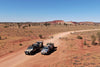
Both sections are signposted off the Victoria Highway and accessed from it by unsealed roads. The Bullita Road into the western section is quite rough with several creek crossings. High clearance 4WD vehicles and offroad-capable trailers are recommended for this journey. That section can also be accessed from the east by a rough track off the Buchanan Highway, and from the south by two 4WD tracks off the Buntine Highway. All roads, including the Victoria Highway, may become impassable during the wet season. To check road conditions, phone the NT Parks and Wildlife office at Timber Creek (08 8975 0888) or Bullita (08 8975 0833) or visit the NT Road Report website.

Heading into the national park along Bullita Road
Please note, I spoke with local rangers who confirmed I was OK to travel to the central campground with my Kimberley Kamper. There are tracks in the park that are 4WD access only and some that allow suitable trailers. The Judbarra/Gregory National Park website shows which tracks are suitable for various vehicles and you can check by calling on 1800 246 199 or roadreport.nt.gov.au.
The park is an adventurer’s delight featuring spectacular range and gorge scenery, rare wildlife, significant Aboriginal culture and European exploration and pastoral history. Amid this awesome natural and cultural landscape, visitors have boundless opportunities for remote bush camping, challenging four-wheel driving, heart-pumping bushwalks, barramundi fishing, river boating, birdwatching and photography. Visitors to the Northern Territory will need a park pass to enjoy it. The most comfortable months to visit the park are May to August when temperatures range between 10 and 35°C.
Indigenous culture
The park encompasses the traditional homelands of several Indigenous groups — the Ngarinyman, Karrangpurru, Malngin, Wardaman, Ngaliwurru, Nungali, Bilinara, Gurindji and Jaminjung people. They all consider this land to have huge spiritual significance and to be an integral part of their cultural identity. They are active participants in the joint management of the park with NT Parks and Wildlife.

A view of the distant ranges from a crest on the Bullita Road
Numerous archaeological sites throughout the park bear testimony to a long history of Aboriginal occupation. Most of the sites are relatively undisturbed and located in remote areas inaccessible by the public. They include surface scatters, stone tools and blades, ochre quarries, burial sites, old earth ovens, stone arrangements, stone bird-hunting hides, fish traps, rock shelter osccupation deposits and numerous rock art sites.
Judbarra’s rock shelters and caves contain some of Australia's most abundant and significant cave paintings. In a style that appears very different from other areas, techniques include painting, stenciling, drawing, printing and engraving, with human figure motifs being most common. Other images include snakes, crocodiles, fish and mammals.
Shared history
The European history of the area began with the discovery of the Victoria River by Captain JC Wickham and Lieutenant John Lort Stokes in 1839. This was followed in 1855–56 by the North Australia expedition led by Augustus Gregory and Alexander Forrest's exploration of the Wickham River area in 1879. These endeavours led to the establishment of a pastoral industry in the Victoria River district, and there are numerous sites throughout the park providing a tangible reminder of this early European history.
Fifteen kilometres northwest of Timber Creek, a large boab tree — Gregory’s Tree — stands within a 2ha reserve as a living monument to his expedition. It bears Gregory’s inscription of his name and the dates of the base camp there. The site is accessed from the Victoria Highway via a 3km unsealed road and a short walk (500m return, 30mins, easy). It is listed on the NT Heritage Register and is registered with the National Estate. The tree also has special significance to the local Ngaringman people and is registered as a sacred site.
Deep within the Gregory section of the park, the Bullita Homestead and stockyards were built by pioneer Charlie Schultz in the 1950s on the banks of the East Baines River. The homestead precinct includes the surrounding garden, meat house, generator shed, windmill, tank stand and stockyards. The area contains many sacred features and is of great importance to Traditional Owners.
Contact between Aboriginal people and European settlers was often marred by conflict and bloodshed over contested land. Jasper Gorge, the most direct passage for pastoralists through the Stokes Range to the Timber Creek depot, was a place of bloody conflict as tribal warriors besieged and killed teamsters, rolled boulders down on passing herds and stole supplies from wagons trapped in the gorge. Strife in the gorge continued well into the 20th century, requiring police intervention as late as 1950.
The physical landscape
The park encompasses vast tracts of rugged terrain, a landscape of spectacular sandstone ranges, soaring escarpments, serpentine gorges, flat-topped mesas and rolling hills. This varied and impressive topography is the result of marine deposits from 1500 million years ago and their subsequent uplift and erosion by the elements.

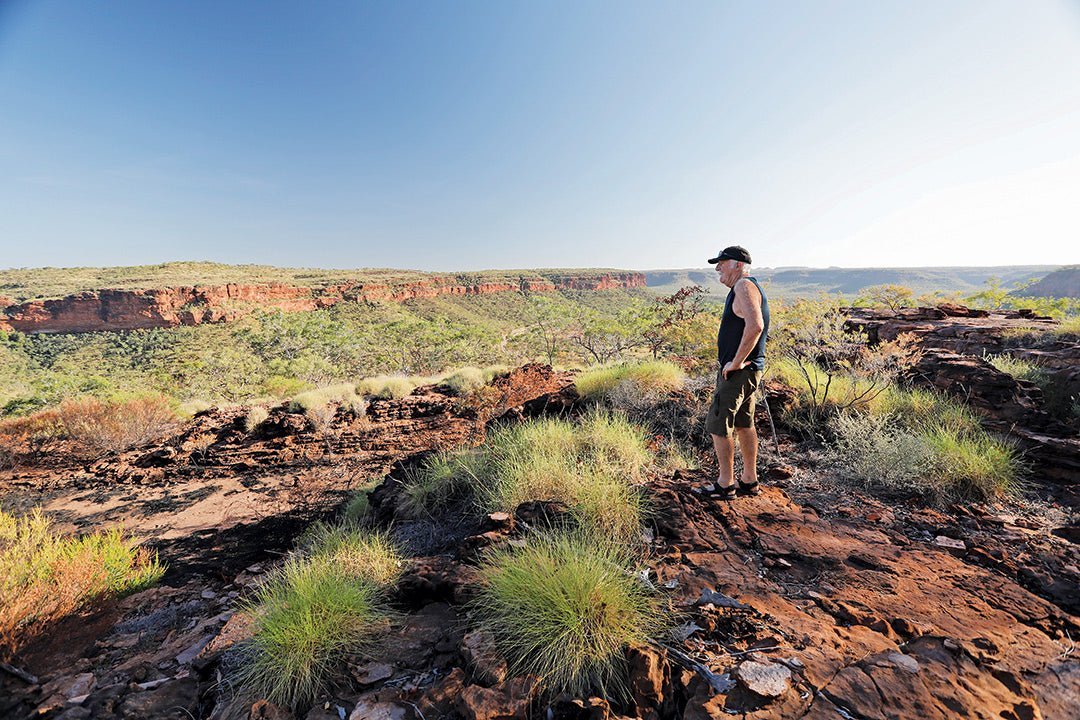
View of the Victoria River Valley from the escarpment lookout
Many beautiful rivers flow through the park — the Victoria (the Territory’s largest), East Baines, Humbert and Wickham. They are joined by numerous tributaries and freshwater creeks that meander through narrow picturesque valleys and cascade over countless waterfalls after heavy rain.
The Victoria River gorge system is more than 40km long and cleaves the Stokes Range near the Victoria River Roadhouse, where its blood-red escarpments tower up to 200m above the highway.
One of the most outstanding geological features of the park is the terraced limestone karst field and cave system in the Limestone Creek area. The Bullita caves comprise the longest cave system in the Southern Hemisphere, with more than 100km of surveyed passages. Multiple entrances have been mapped, and a network of passages reveal a complexity greater than any other system in Australia.
There is no public access to the caves for safety, cultural and environmental reasons. But visitors can walk through some of the karst landscape in Limestone Gorge, guided by interpretive signs, and see fascinating tufa formations and stromatolites (fossilised prehistoric life forms).

Sandstone formations on the way into Limestone Gorge
The natural environment
The park spans a transition zone between tropical and semi-arid bioregions of the Territory. This ecological overlap and the sheer size and variety of the park’s topography are reflected in the rich diversity of its flora and fauna.
More than 1000 native plant species are found in tropical woodlands, pockets of monsoon vine-forest, sandstone heathlands, riverine corridors, acacia scrub and spinifex grasslands. The boab is one of the park's most distinctive trees, some specimens hundreds of years old. Elegant Livistona palms cling precariously to rocky outcrops. Waterways are flanked by pandanus and paperbarks.

An old boab tree in the Bullita cattleyards
These diverse communities provide habitats for 334 kinds of native animals, such as wallaroos, wallabies, goannas, water monitors, crocodiles and a myriad of birds.
Fifty-two families of aquatic wildlife are found in the park, together with 58 species of cave invertebrates. The park is internationally significant as an Important Bird Area because it supports populations of endangered white-quilled rock-pigeon, chestnut-backed buttonquail, partridge pigeon, yellow-rumped mannikin, purplecrowned fairywren and Gouldian finch. The waterways attract hundreds of birds and the lower reaches of the Victoria River support significant breeding colonies of waterfowl and feeding sites for migratory shorebirds.
Fishing
One of the main reasons people come to the park is to fish its waterways, especially the Victoria River, for barramundi, salmon, bream, shark and many other species. Fishing from the riverbank is popular at the Old Victoria River Crossing, the East Baines River at Limestone Creek and Bullita and at a number of accessible locations along the Humbert and Wickham Rivers. Be sure to check the size and bag limits for barramundi and other restrictions that apply to fishing the Territory’s inland waters.

The East Baines River
A concrete boat ramp is located at Big Horse Creek campground, west of Timber Creek. Changing tides, hidden snags and rocks make this section of the Victoria River potentially hazardous. A boat ramp is also located at the Victoria River Gorge picnic area. Motorised watercraft are not permitted on the Wickham River due to its significant natural and cultural values.
Four-wheel driving
More than 500km of 4WD tracks traverse Judbarra’s rugged terrain. They offer some of the best remote adventure experiences in the Top End. Most of the tracks are in the Bullita section of the park, entered via the unsealed Bullita Access Road to the campground beside the East Baines River. This is remote country so be informed and well prepared. High clearance 4WD vehicles are required on these challenging tracks and towing trailers is not recommended. They are unsuitable for caravans. The tracks are usually closed by seasonal flooding from late-November to May.

The Bullita Access Road is a good gravel track
The Bullita Stock Route (92km, 8hrs) is the most popular track. The one-way route follows part of an old droving trail into the remote western section of the park, then loops back onto the Bullita Access Track. It passes through scenic limestone-terraced hills and boab-dotted ridgelines. The Tuwakam Track (20km, 3hrs) links the Bullita Access Track to the Buchanan Highway near Jasper Gorge and makes a pleasant day trip from Timber Creek. The Humbert Track (62km, 6hrs) begins near Bullita and winds in a southerly direction through sandstone mesas and over limestone ridges, exiting the park near the Humbert River Station Homestead. It’s part of the more extensive Binns Track which is promoted as “one of Australia’s epic four-wheel drive journeys.”
The Wickham-Gibbie Creek Track (92km, 6hrs) branches off the Humbert Track and traverses hilly country with spectacular views. The southern section of the track has many (probably dry) crossings of Gibbie Creek as it exits the park near the Mt Sandford Station on the way to Kalkarindji on the Buntine Highway. The Limestone Gorge Track (6km one way, 30mins) is a short track off the Bullita Access Road, and travels through an impressive landscape dominated by limestone features, tufa dams and boabs. The Broadarrow Track (187km, 2–3 days) is the park’s most remote and challenging trek, crossing a rugged plateau in the southwest corner to exit via Depot Creek towards the Buntine Highway.
For more information and a map about these 4WD tracks, download the national park brochure here.
Bushwalking
There are many walking trails in both sections of the park to keep fit and active visitors enthralled for days. Most of them are well marked and start close to the Victoria Highway. Carry plenty of drinking water.
Walks in the Victoria River section include:
- The Escarpment Walk (3 km return, 1.5hrs, moderate), a steep, rocky trail with spectacular views of the Victoria River and surrounding escarpment
- The Joe Creek Walk (1.7km loop, 1.5hrs, moderate), ascends through Livistona palms on a scree slope to the base of an escarpment with some Aboriginal art in the overhangs and breathtaking views
- Kuwang Lookout (100m), a short stroll to a viewpoint with interpretive boards offering Aboriginal dreaming stories and tales of explorers and pastoralists.

The Joe Creek Walk through the Livistona palms along the edge of the escarpment
In the Bullita section of the park, walks include the Calcite Flow Walk (600m return, 30mins, easy) that explores a curious feature of the karst landscape in a boulder creek bed of Limestone Gorge with pleasant views of the surrounding ridges and the Limestone Ridge Walk (1.8km loop, 1hr, moderate) that leads to lookouts with excellent views of the gorge’s karst country and the East Baines River valley.
Camping and accommodation
There are several campgrounds with toilets, picnic tables and fireplaces within the national park. Online bookings must be made in advance and fees apply (head here for more information and to book a site). You can't pay at the site. Sullivan Creek Campground is located about 15km within the eastern park boundary beside the Victoria Highway. A nearby waterhole offers a short walk and fishing. This campground is mainly used as a roadside stop, picnic area or overnight camp for highway travellers.
In the western section, you will find developed campgrounds at Big Horse Creek and Bullita Homestead. Big Horse Creek (08 8975 0888) is next to the Victoria Highway, 10km west of Timber Creek. It’s open all year and is a popular base for anglers who launch their boats from the sealed boat ramp. There is limited drinking water. Bullita Campground, 60km south of Timber Creek, is close to the East Baines River and the historic homestead.

A site at the Homestead campground
Remote bush camping with no facilities except fireplaces is also available in the Bullita section at Drovers Rest, East Baines Crossing, Limestone Gorge (toilet), Fig Tree Yard, Top Humbert Yard, Escarpment Lookout, Camel Point, Wilingarri, Paperback Yard (toilet), Depot Creek and Jasper Gorge (outside the park).
Outside the park, commercial accommodation and campgrounds are located at Timber Creek and Victoria River Roadhouse, which also provide telephones, meals, fuel and limited supplies.
THE NEXT STEP
If you want to learn the latest caravan news, find the most innovative new caravans and camping gear or get inspired to plan your next adventure to some of Australia's best getaway destinations, subscribe to our weekly newsletter. We promise to send you only the best content.
Related Articles:


Judbarra-Gregory National Park, NT: An adventurer's haven