
Mary River National Park, NT: The best things to see and do
Often overlooked by tourists in their rush to Kakadu, the Mary River National Park offers excellent opportunities for wildlife viewing, recreational fishing, river cruising, bushwalking, four-wheel driving and bush camping.
The Mary River National Park is not a unified conservation area but a patchwork of 14 separate parcels scattered across the coastal lowlands between Darwin and the western boundary of Kakadu National Park.
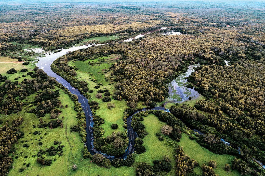
Collectively, these 14 parcels encompass 112,000ha of the Mary River catchment, one of several large rivers that flow through these floodplains into the Van Diemen Gulf.
The Mary rises near Pine Creek and flows 225km through a catchment spanning 8000sq km drained by 10 tributaries. The river only flows in the wet season, when it inundates one of the most extensive freshwater swamplands in Australia. During the dry season it shrinks to a series of pools and billabongs. It’s unique among Top End rivers in that it has had no major tidal estuary outlet for at least the past 2000 years. The catchment lies within the ‘monsoonal tropics’, so named for the hot, seasonally wet climate that prevails across the coastal and northern inland of the Northern Territory.

This torrid climate fosters a wide variety of plant communities in the national park. Large sections of the coast are lined with mangrove forests, which are nursery areas for many marine species. The mud flats and swamps are important feeding and roosting habitats for millions of waterbirds and waders. Estuarine systems are home to huge numbers of saltwater crocodiles, dugongs and several species of threatened sawfish. The sandy beaches and coastal dunes provide important nesting grounds for seabirds and six species of marine turtles.
Away from the coastline, the landscape is dominated by open forests of Darwin stringybark, woolly butt and bloodwoods, which grow up to 20m tall. Most woodlands have an understorey of tussock grass, speargrass, with a mid-layer of acacias, pandanus and a variety of palms. Small patches of monsoon rainforest (vine thickets) dot the coastal fringes and waterways.
Throughout the low-lying floodplains a maze of wetlands, billabongs and swamps comprise freshwater habitats that support diverse species of plants, fish and aquatic invertebrates. The area is renowned for its prolific birdlife and large concentrations of migratory shorebirds. Some 250 species are commonly seen, including the world’s largest breeding colony of magpie geese in numbers exceeding 400,000 birds. More than 300 kinds of other animals inhabit the park, including nine species that threatened or endangered.

The park spans the traditional country of the Limilngan, Wulna and Uwynmil Aboriginal people, who jointly manage it with the NT Parks and Wildlife Commission. The Mary River floodplain is intersected by the pathways of ancestral spiritual beings and ‘Dreaming’ storylines that connect more than 20 sacred sites throughout the park. Many significant archaeological places have also been identified, including burial and ceremonial grounds, shell middens and stone arrangements.
History
On 24 July 1862, after crossing the Mary River floodplain where clouds of mosquitoes gave them “no rest night and day”, John McDouall Stuart and his party of explorers stepped onto the beach at Chambers Bay to complete an epic 3400km transcontinental journey. To mark the place where they reached the coast, Stuart carved his initials ‘JMDS’ into a large tree.
In 1902, a fire burnt the tree to a charred stump. Seventy years later, a memorial cairn was erected where the tree once stood, and it may be seen today on a 6km (return) walk through a dedicated reserve and day-use area.
The main economic activity in the region between the 1880s and the mid-1950s was buffalo shooting, principally for their hides and horns. After an abortive attempt to produce buffalo hides for an Australian market on Cobourg Peninsula in 1876, the animals were released from captivity and formed large, feral herds that migrated across the lowland floodplains and swamps east of Darwin. Paddy Cahill, the best known of that first generation, introduced the method of shooting from horseback. The industry was a major employer of Aboriginals in the region from these early years, as evidenced by complaints from Darwin residents about the difficulty of finding domestic help during the shooting season (May–October). After World War II, a new market for crocodile skins encouraged shooters to exploit the large number of saltwater crocodiles in the lower reaches of the north coast rivers, until a hunting ban (without a permit) was introduced in 1971.
Often overlooked by tourists in their rush to Kakadu, the Mary River National Park offers visitors excellent opportunities for native wildlife viewing, recreational fishing, river cruising, bushwalking, four-wheel driving and bush camping. The best time to visit the park is in the dry season (May–October), when most areas are accessible to all vehicles. However, many roads are unsealed and these are usually closed due to seasonal flooding (plus the accompanied heavy rain and weather conditions) in the wet season. You’ll need a NT Parks Pass to enter at any time of the year and these can be obtained online.

Wildman River
The Wildman River section is the main focus of tourist activity in the park. It’s accessed via Point Stuart Road, which turns off the Arnhem Highway 19km west of the Bark Hut Inn. As it heads north along the eastern edge of the park, the road is sealed for the first 17km, to the Wildman Wilderness Lodge (now closed) turn-off and unsealed for the next 37km to Shady Camp. This gravel section is accessible by 2WD vehicles in the dry but can become corrugated late in the season. Rockhole Road and Wildman Road are gravel roads branching off Point Stuart Road, enabling 2WD access to various visitor attractions close to the Mary River. These two branch roads are joined by the Wildman 4WD Track, which is closed during the wet season. Beyond the Shady Camp turn-off, Point Stuart Road becomes a 4WD track all the way to the coast and is impassable during the wet season, remaining closed for long periods.

Access to the western side of the park is via Hardies 4WD Track from a highway turn-off a few kilometres before the Mary River Crossing, if you’re coming from the west. This route is only open during the dry season and continues north through the verdant heart of the park, connecting Mary River, Bird and Corroboree Billabongs.
Both 4WD tracks are well defined, signposted and marked with blue arrows. An information sheet and map for each track can be downloaded from the national park website at nt.gov.au
The best place for viewing wildlife is on the water, where you can get great shots of birdlife and saltwater crocodiles against a backdrop of paperbark swamp and lotus lilies. On land, purpose-built shelters for birdwatching are installed at Bird Billabong and Mistake Billabong, while Shady Camp is the best site in the park for spotting crocodiles from a purpose-built viewing shelter beside the river. Couzens Lookout on the Mary River offers some of the best views over a billabong festooned with water lilies, especially at sunset.

Top fishing
The Mary River region is an angler’s paradise, offering some of the best recreational fishing in the Top End. The river and floodplain environments are major breeding grounds for 34 fish species, such as sooty grunter, spangled perch, bony bream, freshwater longtom and the much sought after barramundi. All wetland areas of the park are open for recreational fishing, although regulations impose size and possession limits for some species and restrictions on the use of nets, traps and spears without a permit.
The Mary River and its floodplains are covered by the Mary River Fish Management Zone, extending from the coast to just south of the Arnhem Highway. For information about zone specific rules and regulations click on this link.

Corroboree Billabong and Shady Camp are considered two of the best fishing spots. Both have boat launching facilities and are known nationally for the chance to catch big barramundi. Other boat launching sites within and adjacent to the park are located at Rockhole, Mary River Crossing, Hardies Lagoon, and along the Hardies 4WD Track at Delta Block East and Delta Block West. Stuart’s Tree Fishing Camp (Point Stuart) has a private boat ramp and charges apply. (For access phone 08 8978 8863 or 08 8983 1223)
A number of commercial operators conduct fishing tours and eco-cruises on the Mary River, usually launching at Shady Camp, Corroboree Billabong and Rockhole. For more information contact Corroboree Billabong Wetland Cruises (P: 08 89 855 855) and Point Stuart Wilderness Lodge (P: 08 8978 8914).

Bushwalking
Several bushwalking trails give visitors the opportunity to experience a range of habitats at close quarters. The Brian Creek Monsoon Forest Walk (Easy, 2km return, 45min) is shaded by a dense canopy of ancient banyan trees and liana vines leading to a small pocket of rainforest boasting an awesome strangler fig. The Jimmy Creek Monsoon Forest Walk (Easy, 1.6km loop, 30min) is a formed track and boardwalk behind the Point Stuart Wilderness Lodge. The dense forest provides a cool, shady habitat for the unique orange-footed scrub fowl and the many fruit-eating birds that can be seen and heard in the canopy.
The Bird Billabong Walk (Easy, 4.5km, 2hr) provides access to a picturesque billabong, between the Mount Bundey Hills and the Mary River channel, and is noted for its prolific birdlife which can be viewed from a convenient platform. The Point Stuart Coastal Reserve Walk (Hard, 6km return, 3hr) is only accessible from May to October via a 4WD track. The track leaves dry woodland as it heads out over hot, exposed floodplains, through a coastal vine thicket to coastal mangroves on the shore of Finke Bay, passing Stuart’s Memorial Cairn along the way.

Where to stay
Within the national park, formal camping areas with basic facilities are located at Couzens Lookout (secluded camping beside the Mary River) and Shady Camp (a popular spot for fishing with boat ramps, viewing platform, picnic areas and toilets). Fees apply.

Commercial accommodation in the Mary River region outside the park ranges from luxurious eco-style lodges and air-conditioned cabins to caravan parks with powered and unpowered campsites. You can check out these options at the following locations:
Annaburroo Billabong
P: 08 8978 8971
Bamurru Plains
P: 1300 997 194 / 02 9030 6313
Bark Hut Inn
P: 08 8978 8988
Breeze Holiday Parks – Mary River
P: 08 8978 8877
Corroboree Park Tavern & Caravan Park and Camping Ground
P: 08 8978 8920
Point Stuart Wilderness Lodge
P: 08 8978 8914
Stuart’s Tree Fishing Camp
P: 08 8978 8863 / 08 8983 1223
THE NEXT STEP
If you want to learn the latest caravan news, find the most innovative new caravans and camping gear or get inspired to plan your next adventure to some of Australia's best getaway destinations, subscribe to our weekly newsletter. We promise to send you only the best content.


