
Victorian Lighthouses
CAPE NELSON LIGHTHOUSE
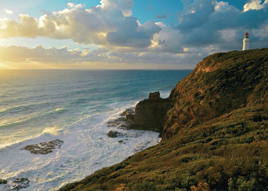
Tucked away on Victoria’s south-west coast, the circa 1884 Cape Nelson Lighthouse sits high on a craggy promontory, where the freshest air imaginable blasts across towering cliffs.
Situated 21km south-west of Portland, the lighthouse was constructed from bluestone overlooking a treacherous stretch of coastline at the far edge of Victoria’s Shipwreck Coast — more than 700 cargo and passenger ships have come to grief along the Shipwreck Coast. Rising 50m above the ocean, the tower’s beam reaches miles out into the Southern Ocean, announcing to shipping from the west that Bass Strait is ahead.
In late 1884, when the ‘Russian Scare’ was at its height, the lighthouse was connected to Portland by telephone, and the following year a 2m telescope was installed to “scrutinise passing ships of hostile intent.”
Cape Nelson’s telescope and telephone also played a strategic role during WWI, although no German raids were sighted. During WWII a radar station was established to provide early warning of Japanese warships.
Today you can take a guided lighthouse tour, hike a 3km clifftop walk, and set off on parts of the Great South-west Walk. During summer months, blue whales frequent the area and in winter southern right and humpback whales are seen off the coast.
While there are caravan parks aplenty in Portland, for a treat the historic lighthouse keepers’ houses have been transformed into 4.5-star accommodation — without doubt the state’s most upmarket lighthouse accommodation.
Cape Nelson is 360km south-west of Melbourne. Daily lighthouse tours adults $15, children $10, families $40. W: capenelsonlighthouse.com.au.
CAPE OTWAY LIGHTHOUSE
Constructed 90m above sea level, overlooking the stormy confluence of the Southern Ocean and Bass Strait in 1848, Cape Otway Lighthouse is the oldest surviving beacon of its type on mainland Australia.
Weather around the Cape can turn from a breeze to a force ten gale in no time, when winds of up to 130km/h rip across the cliffs and waves crash across the saw-like rocks of Otway Reef, 2km offshore.
The light-station was like an island in the bush for early lighthouse keepers and their families. There was virtually no way in or out of the Cape, and supplies were delivered every 6–12 months, landed at Parker River and brought overland. A road was later cut from Colac but was not passable to motor vehicles until the mid-1930s.
Today Cape Otway is scenic drive across the glorious rainforests of the Otway Ranges from Colac, or a half-hour drive along the Great Ocean Road from Apollo Bay.
The beautifully preserved lighthouse and grounds makes for a fascinating glimpse into Australia’s maritime history.
The lightstation grounds also include the circa 1859 Telegraph Station, where Australia’s first submarine cable was laid between Cape Otway and Launceston, and a WWII radar bunker.
The war came to Victoria’s doorstep in 1940 when a German tanker planted 110 sea mines across Bass Strait. The RAAF took over Cape Otway in 1942, and it became known as 13 Radar Station RAAF, staffed with one flight lieutenant and 45 airmen. Top-secret 13 Radar’s role was, “to provide Air Warning by means of RDF equipment” — namely, then-new radar.
Cape Otway recently opened a history project, WWII Memories, in the concrete bunker housing original radar equipment.
A visit to Cape Otway is particularly important at this time as, due to issues relating to the lease between the Victorian State Government and the current owners, the light-station may close.
Admission to the light-station grounds is $19.50 adults, $7.50 children, $49.40 family, and includes access to the lighthouse tower, Telegraph Station and radar bunker. Comfy accommodation in historic cottages from $240 per double. W: lightstation.com.
Cape Otway is 218km south-west of Melbourne via Apollo Bay, 90km south of Colac.
SPLIT POINT LIGHTHOUSE
Legend has it Split Point Lighthouse at Aireys Inlet is haunted. It’s claimed the beacon is inhabited by the ghost of a young woman who got too friendly with a young man and suffered a watery death at the hands of her outraged father, a 19th century lighthouse keeper.
The haunted theme is nothing new to the legions of young fans of the television series Round the Twist — Split Point is recognised as the haunted lighthouse in the popular children’s program.
Split Point’s supernatural resident is one of many captivating tales of the much-loved landmark along the Great Ocean Road.
Climb the narrow 33m spiral staircase to a magnificent crystal lens that beams 21 nautical miles out to sea. This climb is well worth the effort when you reach the balcony, which has 360-degree views, including Fairhaven Beach, Painkalac Creek, the rugged cliffs of Eagle Rock, and Angahook-Lorne National Park.
Aireys Inlet is 125km south-west of Melbourne. Accommodation options include several caravan parks. The lighthouse is open daily for tours, weather permitting. Self-guided tours $10 per person, guided tours available. W: splitpointlighthouse.com.au.
POINT LONSDALE LIGHTHOUSE
At low tide, the seawaters in the rock pools at Point Lonsdale are so transparent it’s like looking into a bathtub. Rock rambling near Point Lonsdale’s headland, you see colourful marine fauna swaying at the bottom, and sometimes tiny seahorses, sea-stars, and darting fish.
Situated on the Bellarine Peninsula, Point Lonsdale’s extraordinary geography of rock pools, protected beach and sweeping ocean shores makes an ideal seaside sojourn in any season.
Point Lonsdale’s lighthouse keeps vigil over the entrance to Port Phillip Bay, known as The Rip, a 3km stretch of waters between Points Lonsdale and Nepean, regarded as one of Australia’s most treacherous.
Its reputation is well-earned — between 1841 and 1890 more than 30 ships are known to have been wrecked.
Built in 1902, Point Lonsdale Lighthouse is the only Australian beacon still manned 24-hours a day. The traffic through Port Phillip Heads is almost constant — pilot boats churn through the turbulent waters leading ships through the Heads, and yachts and fishing boats pass by.
You can join a tour of the lighthouse, conducted by the Queenscliff Maritime Museum, and take in sweeping views along the coast to Ocean Grove and Cape Schanck from the lantern room. Adults $10, concession $8, children $5. W: maritimequeenscliffe.org.au.
Point Lonsdale is 104km south of Melbourne. A range of accommodation options includes caravan parks.
CAPE SCHANK LIGHTHOUSE
During the winter months, salt-whipped winds can roar across the cliffs at Cape Schanck — there’s nothing but the Southern Ocean between here and Antarctica — and the ocean pounds onto jagged rocks.
Situated just over 100km south of Melbourne on the southernmost tip of the Mornington Peninsula, Cape Schanck Lighthouse is perched on the eastern point of a triangle of lights that beam across Victoria’s busiest shipping lanes — Cape Otway and Cape Wickham on King Island make up the other points.
Construction of the 21m limestone lighthouse began in 1857, making this one of the country’s oldest beacons.
At dusk, the enormous crystal lens at the tip of the lighthouse, shaped like a huge glass beehive, starts beaming, flashing 26 nautical miles out to sea. The original clockwork mechanism is still in place, although the light is now turned by an electric motor.
Visitors can explore the lighthouse precinct anytime (6am–6pm), but to go inside the lighthouse and climb its 59 limestone spiral steps you must join a guided tour (adults $14, children $8, family $40). This includes tours of the museum and former lightkeepers’ cottages. W: facebook.com/lighthousecapeschanck.
WILSONS PROMONTORY LIGHTSTATION
Between 1853 and 1859 convicts laboured on an isolated, windswept bluff at Wilsons Promontory, using local granite to build a lighthouse that looms 90m above Bass Strait’s storm-tossed seas.
Pack your walking boots before you venture to this remote, pristine location, as you can only reach Wilsons Promontory Lightstation, the southernmost settlement on Australia’s mainland, by hiking to it.
The 19.1km inland route via the Telegraph Saddle car park climbs through eucalypt forest and coastal tee-tree scrub, while the 23.8km coastal route from Tidal River traverse’s granite-strewn landscapes.
Comfortable lodgings await in three cottages that were once home to lighthouse keepers’ and their families, who had the lonely but vital task of keeping the light burning. One cottage accommodates up to 12, another up to eight, or snuggle up in romantic Banks Cottage for two.
In the 1800s and early 1900s supplies were delivered by ship every six months. These days it’s still so secluded supplies are brought in by helicopter only twice a year.
The Prom’s light-station commands almost 360-degree views of Bass Strait and several rocky islands, heart-stirring panoramas that were once only the realm of residents.
When you’re not soaking up the sheer magnificence of this remote place, watch resident wombats amble around and seals lazing on rocks below. Whales pay regular visits during winter and spring, and dolphins are seen year-round.
At night, the light at this still-operating beacon is visible for 25 nautical miles, at a site so exposed to the elements that wind gusts up to 165km/h have been recorded.
Wilsons Promontory National Park is 238km south-east of Melbourne. Caravan/camping is available at Tidal River. Lighthouse accommodation from $131.50 per person per night. W: parks.vic.gov.au.
POINT HICKS LIGHTHOUSE
For decades controversy raged about Cape Everard. Was it the site of Lieutenant James Cook’s first sighting of Australia’s east coast in April 1770, or not?
Sailing in the Endeavour from New Zealand, Cook, steering westward, came upon a rocky cape first sighted by his second-in-command Zachary Hicks.
Cook called the promontory Point Hicks. But the name eventually fell from use as on later voyages ship’s captains could not find the point at the position Cook recorded, which is in fact in the open sea.
The site was renamed Cape Everard in 1852. But in 1970 then Victorian Premier Henry Bolte decided the bicentenary of Cook’s first sighting of Australia was a good time to set the record straight, and Cape Everard reverted to Point Hicks.
A narrow gravel road winds 46km from Cann River, 445km north-east of Melbourne, to Point Hicks Lighthouse, set deep within Croajingolong National Park. Stretching 100km along Victoria’s south-east coast from Sydenham Inlet to the NSW border, Croajingolong is a scenic combination of temperate rainforests, sweeping beaches and glassy inlets.
Between 1797 and 1945, some 129 ships were lost along the East Gippsland coast. While lighthouses were built at Wilsons Promontory (1859) and Gabo Island (1862), much of Victoria’s east coast remained in the dark, as it were.
One of Australia’s tallest lighthouses, this 37m beacon took almost two-years to build in this wind-buffed spot and was completed in 1890.
Point Hicks lighthouse still stands like a sentinel in the wilderness; nothing much has changed here since the Endeavour arrived.
The light-station usually offers accommodation in former keepers’ cottages that are, while modest, in the author’s opinion among Australia’s most magical lighthouse stays.
However, due to bushfire impact nearby (Point Hicks is unburnt and as beautiful as ever) and erosion, currently the lighthouse and cottages are closed, hopefully to reopen in 2021. W: parks.vic.gov.au.
Lighthouse tours are only available to guests. To see the buildings, drive 3km past Thurra Campground to the Lightstation Reserve gate. From here, follow an access track along the shore past beautiful Honeymoon Bay and bushland to the lightstation.


