
Exploring Port Fairy
Port Fairy straddles the estuary of the Moyne River where it enters the Southern Ocean, 290km west of Melbourne. Situated in a spectacular coastal setting about halfway between Cape Otway and the South Australian border, this charming town is a popular holiday destination with a picturesque harbour, elegant Victorian buildings and a famous folk festival. Home to around 3,400 people, it was voted the world's most liveable city of its size in 2012.
THE MOYNE COAST
Beginning about 25,000 years ago, a series of volcanic eruptions created a basalt plain contorted by irregular ridges, depressions and cones that rise up to 180m. One of these relict formations is Tower Hill, 15km from Port Fairy. This dormant volcano is the central feature of a conservation reserve, established in 1892, in which several walking trails around the crater’s edge provide panoramic views of the surrounding countryside.
The Moyne River rises near Stonefield and meanders southward for 82km through a picturesque agricultural landscape before spilling into Belfast Lough and continuing to its mouth on Port Fairy Bay. The south side of the river mouth is dominated by Griffiths Island, which is actually three separate islands that became joined by sand accumulating from man-made alterations to the local environment. For six months each year (September–April), the island is colonised by thousands of breeding muttonbirds (short-tailed shearwaters) during their 15,000km migration around the Pacific.
Opposite Griffiths Island, East Beach curves north-east towards Warrnambool, forming the seaward edge of the Belfast Coastal Reserve, a complex of coastal dunes and salt marshes that provide vital habitats for migratory wading birds and Victoria's largest population of endangered hooded plovers. Weaving through the reserve is a 22km walking trail named after the fabled Mahogany Ship, a 16th century Portuguese caravel thought to have been wrecked on the coast and now lying somewhere beneath the dunes.
To the west of Griffiths Island, the Crags Coastal Reserve protects 12km of spectacular scalloped bays enclosed by jagged limestone cliffs and rock platforms. Further west, the coast is fringed by the Yambuk Nature Conservation Reserve, a 10sqkm tract of dune shrubland around wetlands in the lower reaches of the Eumeralla River and Lake Yambuk. This is an internationally significant habitat for migratory shorebirds and other critically endangered species.
Six kilometres offshore lies Lady Julia Percy Island, a flat-topped volcanic outcrop edged by sheer cliffs that rise almost 50m above the surrounding reefs and rock platforms. The island supports the world’s largest colony of Australian fur seals (estimated 27,000), as well as breeding colonies of little penguins and seabirds. Local charters offer cruises to the island, weather permitting.
INDIGENOUS HERITAGE
Port Fairy lies within the traditional lands of several Aboriginal groups who broadly identify as Maar and Eastern Gunditjmara people. Their cultural landscape abounds with sacred sites and artefacts that mark their ancestors’ physical presence for thousands of years and signify an ongoing spiritual connection with Country. The area around The Crags is of particular archaeological significance with many sites listed on the National Estate.
In July 2011, the Federal Court recognised these Indigenous people as co-holders of native title over Crown land extending from Yambuk in the west to the Otway Range in the east, and offshore to include Deen Maar (Lady Julia Percy Island) and the Twelve Apostles. Their rights and interests are represented and managed by the Eastern Maar Aboriginal Corporation.
EUROPEAN SETTLEMENT
The Moyne Coast was charted by early mariners, such as James Grant (1800), Matthew Flinders and Nicolas Baudin (both in 1802). In their wake followed whalers and sealers who hunted marine mammals in the Southern Ocean for their fur, leather and oil. One of these was Captain James Wishart who prowled the coast in his cutter Fairy, often using the Moyne River to shelter from the furious storms that lashed the region. In time, this natural haven fostered a settlement that became known as Port Fairy.
In 1835, John Griffiths established a whaling station at the mouth of the Moyne River, on the island that now bears his name, where more than a hundred men processed southern right whales and fur seals. The workers built huts along the river mouth, shops sprang up to supply them and nearby land was settled to farm crops and graze cattle.
By the 1840s, the seals and whales had been hunted to virtual extinction and, although the station’s heydays ended, the settlement’s fortunes continued to rise on the back of agriculture and maritime commerce. In 1843, Sydney solicitor James Atkinson purchased 5,000 acres (2,000ha) and converted the sealing community into a port by draining the swamps, subdividing and selling the land and building a harbour on the river. He named the town Belfast after his hometown in Ireland and, by the 1850s, it was the largest privately-owned town in Australia, with a population of almost 2,200.
As agriculture developed rapidly on the district’s fertile river flats and rich volcanic soil, Belfast became an important regional centre and one of the busiest ports in the colony, with a steady stream of vessels supplying markets in Melbourne. In 1856 the town area was proclaimed a separate municipality, the first outside Melbourne and Geelong, and in 1887 it was renamed Port Fairy by a special Act of Parliament.
THE FORTIFIED PORT
When whalers first arrived, the Moyne River flowed into Port Fairy Bay through an estuary of narrow channels to an outlet over a shallow sand bar. As the settlement grew and trade prospered, ships were forced to anchor in the bay, transferring their passengers and cargo to the river port by boats and lighters, or not at all if the surf across the bar was too rough. To improve accessibility and reduce the need for dredging, the river mouth was significantly altered by the construction of extensive training walls and breakwaters that directed the flow into the bay.
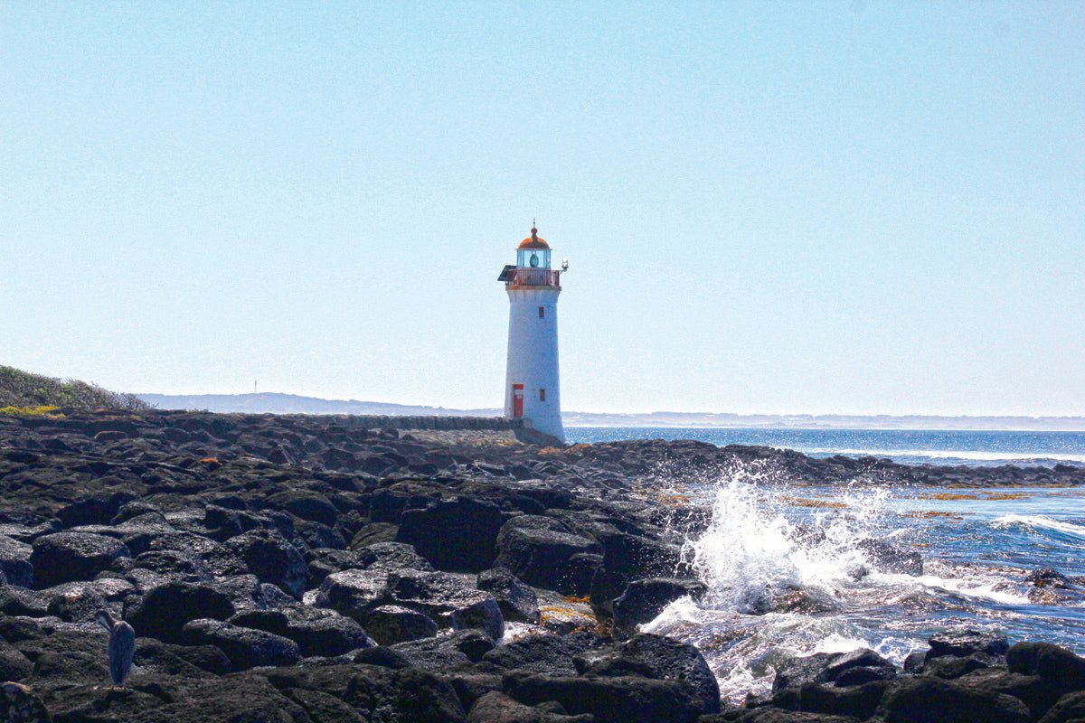
The rapid increase in maritime traffic prompted the construction of a lighthouse on the northern tip of Griffiths Island, at the mouth of the river. The 11m lighthouse was one of four harbour lights constructed by the Public Works Department in 1859, and is the only one still standing in its original location, unusually at sea level.
Over time, the port facilities were expanded by jetties, warehouses, tram tracks for the dispersal of goods and a life boat station with slipway access to the river. To accommodate large vessels, and protect them from the bay’s fickle elements, a turning basin was cut into the eastern bank of the Moyne. Today, this basin serves as a marina for private yachts.
In 1861, the Harbour Master’s signal station was constructed on Flagstaff Hill, an elevated spit of land with a commanding view of the bay and the river mouth to Griffiths Island. Its strategic location made the site ideal for redevelopment in the 1880s with large-scale fortifications. Re-named Battery Hill, the concrete bunkers and gun emplacements were part of a broader strategy to bolster the young colony’s coastal defences against a much-feared Russian invasion. The guns have only ever been used for training purposes and civic celebrations, such as King George V’s coronation in 1911.
By then, however, the town’s fortunes were in decline. The bay was exposed to south-easterly gales which had wrecked more than twenty ships during the 19 century by driving them, anchors dragging, onto East Beach and the Crags. Despite the extensive modification of the river mouth, the port was eclipsed by neighbouring Warrnambool and Portland, with their breakwater-protected harbours. Substitute industries were developed to shore up the town’s flagging economy — guano was mined on Lady Julia Percy Island for fertiliser, a Glaxo dairy factory emerged as an important local employer, and the Moyne wharves became the home of what is today one of Victoria's largest fishing fleets.
PORT FAIRY TODAY
Modern-day Port Fairy is the principal town of the 5500sqkm Moyne Shire, which boasts a diverse economy based on agriculture, dairying, seafood processing, pharmaceuticals, manufacturing and education centres. The Port of Port Fairy encompasses a scenic 1300m stretch of the river from a footbridge across its northern boundary to its mouth at Griffiths Island. The Port is managed by the Shire Council for use by commercial fishermen and charter boat operators, as well as recreational boaters, yachts and leisure craft.
Tourism has surpassed commercial fishing as the mainstay of Port Fairy’s economy and, with its rich maritime history and magnificent coastal environment, the town has plenty to offer visitors in recreational activities.
Port Fairy is considered Victoria’s finest colonial coastal village, with more than fifty buildings classified by the National Trust. A heritage walking trail reveals a wealth of distinctive mid-Victorian architecture, including rustic bluestone cottages, imposing churches, elegant banks, municipal and government buildings, and hotels that claim to be among the oldest continuously licensed premises in the State. The Port Fairy History Centre, housed in the old Court House (1859), provides copious local information and has an extensive display of memorabilia and photographs from the late-19 and early-20 century.
The Maritime and Shipwreck Walk explores King George V Square, the port precinct along the Moyne and the neck of land between the river and Port Fairy Bay, which encompasses the botanic gardens, Battery Hill fortifications, the old Mill, and the historic lifeboat station. The walk around Griffiths Island is highly recommended. Starting at the causeway just off Ocean Drive, a path circumnavigates the island through the shearwater nesting colony, along sandy beaches, rocky coves and past the lighthouse on the island's eastern extremity.
The wharves are popular with anglers, as are the river mouth, East Beach and Port Fairy Bay. Unlucky anglers will find great consolation in the many fish and chip cafes, bakeries and restaurants around the town. Surfers can catch some dynamic breaks near the entrance to the Moyne River and off Griffiths Island. East Beach is patrolled and considered one of the safest beaches on this stretch of coast, making a relaxing seaside venue for families.
The Port Fairy Folk Festival is held during the Labour Day long weekend in March each year. During its 44 years of operation, it has attracted more than one million attendees and become the town’s single largest source of non-local income. Visitors are spoiled for choice in accommodation with abundant private and commercial accommodation that includes hotels, motels, numerous B&Bs and six caravan parks in locations close to the river and beaches.
PORT FAIRY CONTACTS
PORT FAIRY VISITOR
INFORMATION CENTRE
4 Bank Street, Port Fairy
P: (03) 5568 2682
E: vic@moyne.vic.gov.au
W: portfairyaustralia.com.au/visitor-information-centre
GARDENS CARAVAN PARK
111 Griffiths Street, Port Fairy
P: (03) 5568 1060
E: gardens@moyne.vic.gov.au
W: gardenscaravanpark.com.au
BIG4 PORT FAIRY HOLIDAY PARK
115 Princes Highway (near corner Albert Road), Port Fairy
P: (03) 5568 1145
W: big4.com.au/caravan-parks/vic/great-ocean-road/port-fairy-anchorage-holiday-park\
SOUTHCOMBE CARAVAN PARK
James Street, Port Fairy
P: (03) 5568 2677
E: southcombe@moyne.vic.gov.au
W: southcombecaravanpark.com.au
GUM TREE CARAVAN PARK
8 Amble Lane (off Toolong Rd). Port Fairy
P: (03) 5568 1462
E: gumtreecp@gmail.com
W: gumtreecaravanpark.com.au
PORT FAIRY HOLIDAY PARK
139 Princes Hwy, Port Fairy
P: (03) 5568 1816 or 1800 008 816
E: stay@portfairyholidaypark.com.au
W: portfairyholidaypark.com.au
KILLARNEY BEAACH CARAVAN PARK
125 Mahoneys Road, Killarney
P: 0428 314 823
E: killarneycaravanpark@moyne.vic.gov.au
W: killarneybeachcaravanpark.com.au


