
A Roadtrip Through the Wimmera
When exploring roads less travelled through Victoria’s Wimmera and Mallee, you’re guaranteed three things — more or less empty backroads, interesting towns and villages, and all sorts of hidden treasures to discover, including, in this semi-arid region, at least thirteen lakes.
The Wimmera and Mallee regions occupy an enormous chunk of Victoria. Extending from the Grampians to Rainbow, and from the South Australian border in the west to Navarre in the east, the Wimmera covers an area of approximately 30,000sqkm. The Mallee, which occupies around 41,000sqkm, covers the most north-westerly corner of Victoria, bounded by the South Australian and New South Wales borders.
Both the Wimmera and Mallee are more or less completely flat, meaning driving is easy. More than 60 per cent of land is under agricultural production in this major dryland cropping region, with millions of hectares planted to cereals, pulses, and oilseeds.
A network of small towns — from Goroke, Jeparit, Hopetoun, Rainbow, and Sea Lake to Donald — retain a strong sense community enjoyed since they were established in the mid-to-late 1800s.
Water is a precious commodity out here: annual rainfall is around 440mm for the Wimmera, and a mere 300 in the Mallee, and water from the region’s rivers is the lifeblood of the area.
It is a surprise, then, to discover that throughout the region, where oceans of wheat and other grains sway across vast paddocks, there are sparkling blue oases, where locals swim, water ski, drop a tinny into the water, and cast a line from lake shores shaded by fragrant eucalypts.
A Lakes Loop Trail (download at visitwimmeramallee.com) covers 552km from Edenhope to Donald, or vice versa. We began the journey from Edenhope, almost exactly halfway between Melbourne and Adelaide.
EDENHOPE TO GOROKE, 47KM
Shown as a dominant blue splash on most maps and GPS screens, the reality is Edenhope’s Lake Wallace has, like many parts of Australia, been affected by drought over the past 20 years — it was dry in 2002, had a bit of water after 2010, and then it went dry again.
There’s been water in the lake again for a few years now, although not much during the summer months. It starts to fill again around June/July when swans and brolgas, some of the 120 bird species recorded in the area, build their nests.
A few minutes’ walk from Edenhope’s main street, Lake Wallace, covering 200ha, is popular for boating, water skiing, fishing, and photography — there are bird hides dotted along the 5km-long walking track around the lake.
A few kilometres north of Edenhope, turn off the Wimmera Highway onto the C208 for the 28km drive to Lake Bringalbert. It’s a pleasant drive through undulating countryside studded with redgums where sheep and cattle graze, before pulling into the shady shores of Lake Bringalbert, which covers around 88ha when full.
One of the first European families to settle the area was the Hamilton family in 1846. The Hamilton’s were friendly with the local Jadawadjali Language Group, and the shores of Bringalbert Lake is the site of the first cricket match between local stockmen, who were superb athletes.
Tom Hamilton created a team, which he initially coached, and the Indigenous cricket team went on to play at the Melbourne Cricket Ground on Boxing Day, 1866. Many of the Bringalbert players on the Boxing Day team toured England in 1868, becoming the first organised group of Australian sportspeople to travel overseas.
Today you don’t hear the thwack of cricket bats at Lake Bringalbert — rather, cockatoos hop about majestic 500-year-old redgums, and swans and ducks glide along turquoise waters. There are commemorative panels about the cricket team’s history at the lake edge, which is a tranquil place to pause for a picnic or an overnight stay.
From here it’s 12km north to the hamlet of Minimay, population ten, which boasts a general store and, a few kilometres away, the shimmering blue waters of Lake Charlegrark.
Covering 40 hectares, this aquatic interlude amid vast farms is a popular spot for locals, and visitors lucky enough to discover it, who head to its shady shores for camping, water-skiing, swimming, canoeing, and fishing for Murray cod, redfin and yabbies.
The lake is also home to the annual Lake Charlegrark Country Music Marathon, held in February (COVID-permitting). For 30 years musicians have travelled to this delightful spot to share their music at this community charity event.
Goroke, 26km north-east, is a small town situated on the edge of the Goroke State Forest and is the southern gateway to the Little Desert National Park. Population of around 300, it was originally surveyed in 1882. The town’s wide main street is home to the Goroke Hotel, a small supermarket and a take-away.
In the local Wotjobaluk dialect, Goroke means magpie, so it’s appropriate the town’s grain silo art bears an image of this favourite bird. Sharing space alongside a kookaburra and a galah, it’s a beautiful triptych on the region’s popular Silo Art Trail.
Lake Ratzcastle, 12km south of Goroke, is as dry as a bone. No water, just a sea of grey-green scrub, with the only sign of life a couple of kites wheeling overhead.
GOROKE TO RAINBOW, 129KM
On the 60km drive between Goroke and Nhill the C206 passes through the Little Desert National Park.
The Little Desert is a desert in name only. Spanning 132,000 hectares, the park features extensive heathlands thick with tea-tree, banksia, and sheoak. Flora and fauna include 670 recorded plant and more than 200 bird species, and wildlife — from black-faced kangaroo, bearded dragon, rare red-tailed black cockatoos to its most famous resident, the mallee fowl — abounds.
The town of Nhill, population around 1800, has a main street so wide it contains a large park that includes the town’s large war memorial, rotunda, and a playground. Along the street are shops shaded by verandas, and several grand old pubs.
At Nhill’s circa 1880s Rintoule’s Union Hotel — which in pre-car days had parking for 150 buggies — we dine on a Seafood Basket (fish, scallops, prawns and calamari for $20) and a Beef ‘n Reef (local steak and prawns for $28).
Nhill has been an aviation hub since 1917, when Ivan S. Young became Nhill’s first aviator after training with the Royal Flying Corps. An Adelaide-Nhill-Melbourne return air service was established here in 1930, and the Nhill RAAF No 2 Astro Navigation School was built in 1941, training more than 10,000 people during World War Two.
Today the complex is home to the Nhill Aviation Heritage Centre, which is home to historic aircraft including an Arvo Anson, a Wirraway, and a Tiger Moth.
A stroll around the former RAAF Base on a 1.4km Heritage Walk reveals ruins that include the airmen’s mess, dental hut and parachute packing area.
At the southern end of town is Nhill Lake and swamplands. The lake, built in the 1960s, was originally part of Nhill Swamp. The Corroboree Ground in the swamp area has long been a traditional location where groups would meet and perform ceremonies. It’s said the last large gathering was held around the ancient redgum Corroboree Trees here in 1866.
From Nhill it’s 44km north-east to Jeparit, the road slicing through flat grain-growing country. Every few kilometres you pass the gates of huge farms, the farmhouses hidden by screens of cypress or eucalypt.
The Wimmera River is the largest Victorian river that does not flow to the sea. Rising in the Grampians, it flows through Horsham, Dimboola and Jeparit before terminating at Lake Hindmarsh, Victoria’s largest freshwater lake — when there’s any water in it, that is.
Lake Hindmarsh has been mostly dry over recent years, though in August last year water found its way into the lake for the first time in five years. But it’s dry again during out recent visit.
Around Horsham, Dimboola and Jeparit, the Wimmera River is kept artificially high by the use of weirs, like the one just outside Jeparit, a small wheatbelt town that was the birthplace of former prime minister Sir Robert Menzies.
From Jeparit it’s 32kms north to Rainbow, known as the ‘Gateway to the Mallee.’
RAINBOW TO SEA LAKE, 90KM
Like most towns in the region, Rainbow is characterised by huge grain silos near the old railway line.
Established in 1893, Rainbow was once known as the ‘Metropolis of the Mallee’ — by 1911 the town boasted department stores, a hospital, churches, flour mills, a newspaper, and its own electricity supply. The railway arrived in 1899, and more impressive buildings were erected along Rainbow’s incredibly wide main street, including several hotels and town’s grand circa 1909 Yurunga Homestead (open Sundays).
Following the C277, it’s 38km north-east to Hopetoun, home to another Wimmera/Mallee oasis, Lake Lascelles. On the way, oceans of grain crops stretch as far as the eye can see, and the road is as straight as a ruler in the endless, unbroken landscape.
Guaranteed water filling Lake Lascelles, which is fed by the Grampians Wimmera Mallee pipeline, makes it popular for swimming in pristine waters. A smaller lake next to it, Willow Lake, is dedicated to fishing, all just 500m from Hopetoun’s main street.
A small but vibrant community of almost 600 people, Hopetoun is another gateway. Called ‘The Gateway to the Parklands’ due to its close proximity to the Wyperfeld, Hattah-Kulkyne and Murray Sunset National Parks. The town has a community-owned hotel that serves traditional pub fare, and a popular bakery and cafe. Just south-east of town is Lake Coorong, which only fills up in very wet years.
From here it’s 59km north-east to Sea Lake via the small but interesting town of Woomelang. The town’s century-old Woomelang Hotel is a classic country pub serving traditional meals. Around town are seven mini-silos painted with native birds, including spotted tail quolls and other endangered species of the area, and there’s a shearing shed built from kerosene tins.
SEA LAKE TO DONALD, 105KM
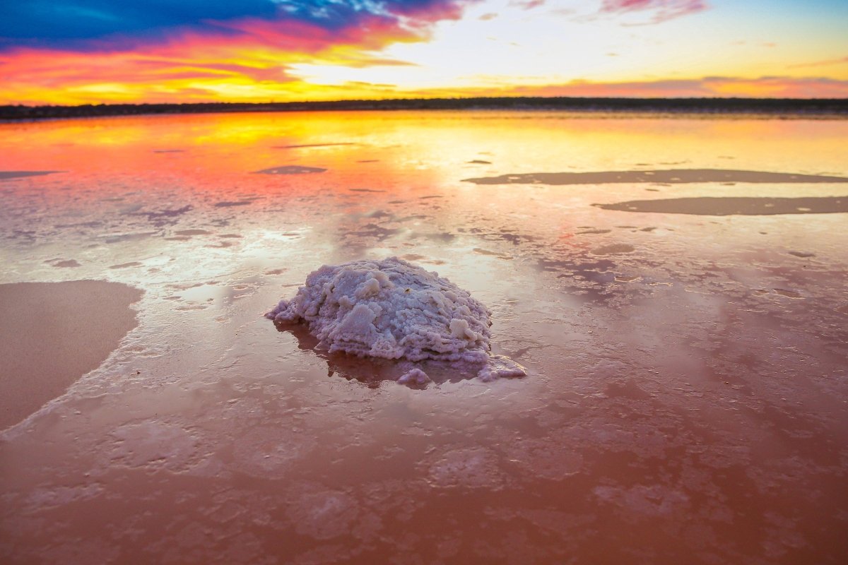
Sea Lake is not by the sea, nor next to a lake. Instead, this small town is seven kilometres from a natural phenomenon, Lake Tyrrell, a place so otherworldly it looks like it’s on another planet.
A salt lake covering about 200sqkm, Lake Tyrrell resembles a moonscape in summer, an endless panorama of white-grey saltpan, as flat as a pancake, glinting in the sun. Salt-makers have laboured here since the 1890s, and still do — today more than 100,000 tonnes of salt is extracted from the lake each year.
In winter, subterranean water pushes up through the salt crust, creating a shallow lake. On calm days, the sky is reflected on the lake’s surface, causing a mirror effect, with the lake and the horizon seeming to melt into one. In spring Lake Tyrrell often shimmers with pink and purple hues, caused by a red pigment secreted from resident microalgae, and is another favourite season for photographers.
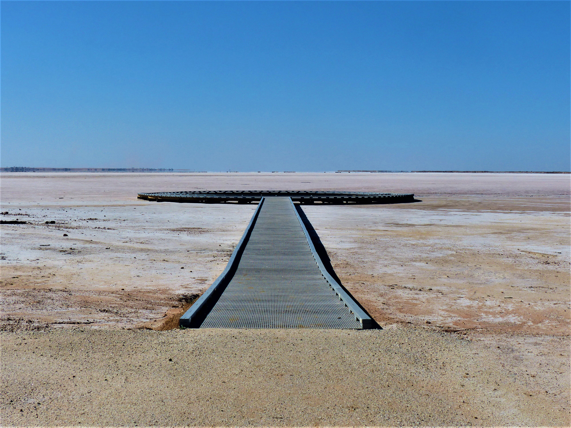
The 120,000-year-old lake is also regarded as one of the best places in Australia for stargazing.
Next to the lake is a ‘Star Lounge’ made up of reclining lounges, where on clear nights — and they usually are — visitors can recline to drink in the incredible vastness of the glittering night skies.
Sea Lake itself is a small, vibrant community, it’s main street featuring a small supermarket, cafes, pharmacy, and the Royal Hotel. When the circa 1910 Royal, the town’s last operating pub, closed its doors in 2017, locals were aghast that Sea Lake had become a town with no pub. So, a group of locals banded together and bought the grand old building and set about restoring it to its former grandeur.
In 2019 this much-loved community hotel reopened with a weekend of celebrations. Today it offers ten accommodation rooms upstairs, and great meals — The Juke restaurant serves an inspired menu that may include anything from Mallee lamb and camembert chicken to seafood burgers.
Green Lake is a small, verdant oasis 10km south of Sea Lake on the Birchip Road. Transparent waters lap sandy beaches at this pretty freshwater lake, which has picnic/barbecue areas, bush walks, and is surrounded by shady black box eucalypts. It’s an ideal spot for a refreshing swim or casting a line into transparent waters.
From here it’s 47km south to Birchip, a small Mallee town surrounded by rich wheat farming lands.
Birchip was settled in 1882. Today it’s home to a huge sculpture of a Mallee Bull in the main street, and vanilla slice heaven at Sharp’s Bakery, three-time winner of the Great Australian Vanilla Slice Triumph. Tchum Lake, 8km east of Birchip, is an artificial lake popular for swimming, boating, canoeing, water-skiing, and fishing and, like Green Lake, is a pleasant place to pause and soak up the tranquillity.
From Tchum it’s 53km south to Donald via the tiny town of Watchem, home to another picturesque lake.
Watchem Lake, once Watchem’s main water supply, is now a peaceful spot where caravans park around leafy gums and owners lap up the serenity with a refreshing swim or kayak and, later, stroll into town to the Watchem Hotel.
Donald, situated halfway between Melbourne and Mildura on the Sunraysia Highway, was first established in 1863. Situated on the Richardson River, the town is a busy service centre to the surrounding district and has a fine lakeside caravan park.
While Donald is regarded as the end of the ‘Lake Loop,’ there’s so much more to see in this region, including Pink Lake near Dimboola, 92km west, via the small town of Minyip.
Minyip is recognisable to many who remember the popular television series The Flying Doctors, which was filmed here from 1985 to 1989. In the TV show Minyip became Cooper’s Crossing, and there are still buildings in town that carry the name from Minyip’s glory years.
The Pink Lake at Lochiel Reserve, 6km north-west of Dimboola, is a salty expanse of wetland that gets its vibrant colour from beta carotene, produced by algae, the only form of life that can survive in this saline environment.
You can get a good view of the lake from the rest stop on the side of the Western Highway. The brightness of the pink hue depends on the amount of rainfall in the area; if it’s dry and there’s less rain, the concentration of pink is stronger.
FAST FACTS
Download the Lakes Loop Trail at visitwimmeramallee.com.au.
Sea Lake Tyrrell sunrise, sunset, or stargazing tours from $60 per person, more at sealaketyrrelltours.com.au.
STAY
- Edenhope Lakeside Caravan Park, on the banks of Lake Wallace, has powered sites from $33 per night. Gas barbies, camp kitchen, recreation room, laundry, stroll to main street, visit edenhopelakeside.com.au.
- Lake Charlegrark Caravan Park and Cottages has powered sites for $30 per night for two people, visit lakecharlegrark.com.au.
- At Lake Lascelles, Hopetoun, there are powered camping sites on the lake from $20 per night, which include hot showers, camp kitchen and flushing loos, contact Mallee Bush Retreat, phone 0439 529 973. Mallee Bush Retreat also has unique farm-style accommodation on the lake, such as little silos, shearers’ hut, and stone buildings.
- Travelling without the van? Nhill’s Rintoule’s Union Hotel has renovated upstairs rooms, most with ensuites, for $100 per double per night, Honeymoon (or second honeymoon) Suite with spa $180. Visit theunion.com.au.
- Powered camp sites at Green Lake are $20 per night for two adults (unpowered $15). Caretaker is usually onsite.
- Powered sites at Birchip’s Tchum Lake are $30 per night for non-members ($20 members), phone 0447 557 873.
- The Donald Lakeside Caravan Park has powered sites for $25 per night. Right on lake, large sites, clean amenities, phone caretaker on 0497 770 064.
FREE CAMPING
- Lake Bringalbert has free camping along grassy lake shores. Shady sites, clean flushing toilet. BYO everything, including water.
- Lake Lascelles Campground, Hopetoun.
- Campers can take advantage of free camping at Lake Lascelles Campground, around the lake, with peaceful water views just 500metres from town. No power or facilities.
- Woomelang Lions Caravan Park has free camping with shower and toilet block, and two powered sites, on the corner of Sunraysia Highway and Proctor Street. There’s also free camping at Cronomby Tanks, a precinct where steam trains once reloaded with water.
- Lochel Bridge Campground is a free camp 5km north-west of Dimboola (off the Western Highway), by the Wimmera River. Flushing toilets, shady trees.


