
On to Oodnadatta
We were driving at 80km/h, watching pieces of gypsum on the track twinkle like stars, when it happened. Strips of black rubber cartwheeled out of the arch, rocks dinged and ground against the exposed wheel, and the car tilted forward as we rolled to a halt. Outside, in a silence broken only by flies, the unintelligible clicking of expanding metal under the bonnet and the occasional F-bomb, we assessed the carnage as beyond the scope of our ARB Speedy Seal tyre repair kit.
The jack fit under and soon we’d fitted our one spare. Ahead lay 120 bare kilometres to Oodnadatta, the hottest and driest town in Australia, where the merc famously kissed 50.7 degrees in 1960. Behind us was William Creek, 60km distant, but that would’ve been backtracking — and, with outback diesel prices, that’s arguably a worse fate than busting another tyre and calling upon the 24-hour recovery service of the Pink Roadhouse.
ABOVE GOYDER’S LINE
We’d set off from Adelaide six days previously, passing the Outback Highway to start on the Oodnadatta Track at Marree. Having been as recently as February, we didn’t drop into the Flinders or Gammon Ranges this time, but highly recommend visiting both while out this way. What lies beyond these desert mountains is even greater outback, defined not by lofty bluffs but by barren, flat landscapes, brought to life intermittently by above and underground water sources, and dotted with service towns, or the ruins of them, galvanised by the Old Ghan Railway, the Overland Telegraph Track, and pastoral and mining interests.
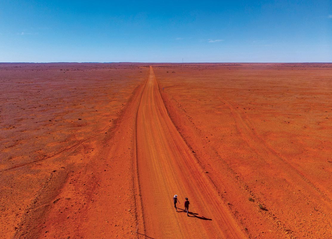
The Oodnadatta Track itself is a 650km unsealed road stretching from Marree in the south to Marla in the north, roughly parallel to the Stuart Highway. Realistically, despite the shredded tyre casings and rusted car wrecks you’ll pass, it’s a relatively safe foray into the bush, especially as it passes through various towns, the track is graded and there’s a bit of traffic — maybe one to three cars an hour on average, including the occasional road train.
Before hitting it proper, drop in at Farina, north of Leigh Creek. Here, various intermittent creeks flow into the Gums Waterhole, which in the old times inspired a stock route from Marree to Beltana and prompted ambitious pastoralists to take up leases north of Goyder’s ominous line. Buoyed by the anticipated arrival of the Old Ghan Railway from Port Augusta in 1882, enthusiastic civil administrators declared the town of Farina in 1878.
Water is like gold here and throughout the region you’ll see old elevated ironwater tanks for storing it where it can’t be evaporated. When these and the waterhole that fed them ran dry, officials were forced to sink wells in the hope of striking the Great Artesian Basin. This workaround offered a lifeline that kept the town going for years, to the extent that 33 Farina-born men enlisted in WWI.
In time, improved road transport reduced this railway town’s relevance, until the persistent last resident left in 1975, five years before the sleepers of the Old Ghan Railway were ripped up and the new line laid down west of the Stuart Highway.
Nowadays, you can camp at a secluded bush camp at Farina Station for $5 a head near the war monument. Firewood for the pits is available at the station and there’s also flush toilets and donkey showers. Choose between 1km and 2.3km morning constitutionals which pass the dry scrub, old wells, and railway relics.
You can also explore the ruins of the old township which are still in good condition thanks to an active restoration society. And, if you’re there in winter, see if you can pick up a loaf from the volunteer-operated underground bakery.
FROM MARREE TO WILLIAM CREEK
Marree is something of a gateway to the outback, also being the starting point for the Birdsville and Strzelecki Tracks, so rightfully there’s little there. You can take the iconic shot parked by the old railway carriage, laugh at the presence of the Lake Eyre Yacht Club, and restock and refuel.
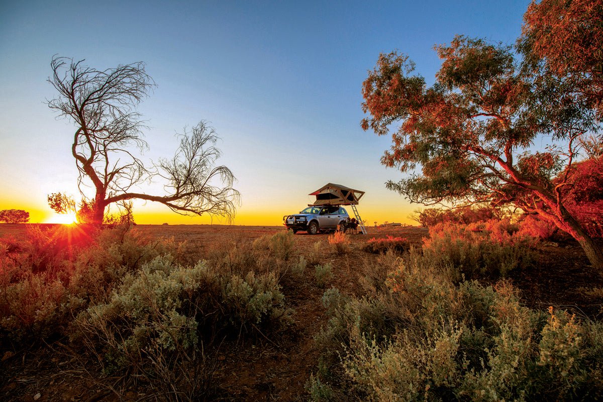
Once you hit the track, you’ll be immediately faced with the flat Mars-like landscapes (barely distinguishable from the road in places) and low, unobstructed horizon that’ll surround you for the next few days; perhaps the over-active neural hardwiring of your city-slicking brain may at first freak out at the lack of stimulation, but soon, if you’re made for places like this, a sense of peace will take over.
The first significant landmark you hit is the walk-through Mutonia sculpture park near Alberrie Creek. Here you can peruse various welded oddities of recycled metalwork: from a robotic man holding a mechanical child, to two joined upright planes (‘Plane Henge’), to a hoverbus — the roosting galahs won’t answer your questions about the randomness of such structures. Further along, the natural attractions take over at the lookout over Lake Eyre South. Dunes decline down to its sandy white basin, 12m below sea level. Hazy mountains, blue in the distance, rise on its far shore. But if you want to get closer, you’re best off taking the 60km detour down to Halligan Bay, from nearer to William Creek. Alternative access to the lake can be had from the 94km Level Post Bay Track, which sets off from Marree.
Along the Oodnadatta Track, you’ll start seeing the iconic mound springs. These mounds form where water flows from underground, forced upward by pressure from the Great Artesian Basin — the world’s largest underwater reservoir, replenished by rainfalls on the west of Queensland’s Great Dividing Range. That water deposits silt and sand on the surface, wind-blown dust adds to the pile, and over time you have a mound.
Indigenous people used them as a water source. They are more reliable, if a little saltier, than gnamma holes. Subsequently the Europeans used them for their own peregrinations (McDouall Stuart followed them North) and later their settlements. The 4km track down to Blanche Cup and the Bubbler is the most viciously corrugated you’ll encounter — it may put on your windscreen wipers without you asking it to — but it’s worth it for your experience of the oasis. Wonder at the huge bubbles rising to the surface and at the lush trail of green weeds following the water flowing down the mounds.
Another prime example of this unique landscapes comes at Strangways Springs, best experienced on short walks (1.8km and 2.2km). After first being taken up as part of a pastoral lease, these springs later became the site of a repeater station for the Overland Telegraph Line, the Commonwealth’s noble attempt at connecting remote Aussie colonies with the Brits.
On this stretch you’ll also be able to see Curdimurka Siding, the best intact ruin of the Old Ghan Railway, with a huge eroded Australian coat of arms out the front.
You’ll soon be in William Creek and, as it goes in these parts, the town was born of the railway. WC specifically built itself up around a traveller’s eating house, but unlike other fads, it outlasted its origins, surviving beyond the introduction of a dining car on the passenger train in 1929. Nowadays it’s a convenient stop, with a mechanic, a fuel station, a small sculpture park, toilets, camping, a restaurant, a hotel, and light plane tours. Drop into the quirky bar, which has akubras and ID cards pinned to the roof, and every inch of the walls jammed with memorabilia.
COOBER PEDY AND THE BREAKAWAYS
Although not technically part of the track, it’s worth dropping into Coober Pedy because of your proximity. The 160km track between William Creek and Coober is pretty featureless; we passed two cars, and a few ranchers on motorbikes droving cattle to water along the road.
After an out-the-window chat, we put the Challenger in high four and drove along the roadside for a kilometre, over gibber and spinifex. Every time we ducked back onto the track because of an impassable cutting we feared a bull might mount the car, or that we’d start a stampede.
Coober Pedy itself is an iconic, rough outback mining town with a population of about 2500, aptly named after the Aboriginal term for ‘white man in a hole’. In the lead-up, you’ll drive past sun-baked mullock heaps and deep shafts on working and abandoned claims, and as you roll into town, it’ll seem that buildings are perched precariously on the edges of these heaps.
It began in 1915 when young fella Will Hutchinson chanced upon a gemstone demonstrating the opal’s unique play of light, inspiring hundreds of men, from all nationalities and walks of life, to troop into nowhere to swing their picks and draw up buckets on windlasses, keeping themselves alive on a few sips of water, all to adorn the necks of the aristocracy.
Come 2020 and Coober Pedy provides over 75 per cent of the world’s commercial opal and has over 20 opal stores. You can time your run in Coober to see the Opal Symposium in April, the Kanku-Breakaways marathon and fun run in May, and the Opal Festival in June. Or, you can simply visit or stay in one of many underground buildings (which maintain a more level temperature than ones above ground can), such as the Serbian Orthodox Church; visit a working mine; ogle at the Coober Pedy Hollywood sign above the main street; visit the late Crocodile Harry’s Underground Nest and Dugout to see a whacky concoction of art, knick-knacks and visitor messages; or play a round of golf on the grassless course.
In the arvo, buy your Kanku-Breakaways permit from the council office for $10 a vehicle and drive up the Stuart to the turn-off to the short loop. At this time of day, you’ll be driving towards the side of the range copping all the sunlight. Once when feathered dinosaurs strutted their stuff, this was a plateau, but it’s now eroded to leave behind flat-topped mesas and crumbly rounded hills, coloured like a melted crayon box of a juvenile Picasso. Pastel ochres bleed and marble into each other and soften yet more as the sun lowers over the horizon. Join the crowds watching the sun go down in camp chairs, and make sure to visit a horizon-to-horizon snippet of the 1946-built 5300km dog fence protecting pastoral lands down south from dingoes.
In our opinion, the Oodnadatta Track is best between Marree and William Creek, so rather than taking William Creek Road back to William Creek, consider going up the Stuart Highway from Coober Pedy until you reach Kempe Road, then taking that to Oodnadatta. This choice will also have you pass through the Painted Desert and Moon Plain. From Oodnadatta, you could then finish off the track, coming out at Marla, or go into Witjira National Park, past the 37C Dalhousie Hot Springs to Mt Dare, and from there up the Binns Track to Alice Springs or perhaps onto the Simpson Desert.
TO OODNADATTA AND BEYOND
Between William Creek and Oodnadatta you’ll pass two major attractions: the Peake Ruins, and Algebuckina Bridge and Waterhole. The first requires a 13km detour along a public access road and is perhaps the best example of the Telegraph era remaining in this area. Meanwhile the huge Algebuckina Bridge crosses the Neale River, one of the more permanent water courses in the area. The bridge is made of 19 spans measuring 30m, and you can brave a walk along the first of them, on a metal grate, or wonder at the bridge’s size from ground level.
Sooner or later you’ll rock up in Oodnadatta, a town with a population of 120–180, largely Indigenous. First incepted in 1890, the town was the end of the line for the Old Ghan Railway. Where people go, businesses follow, and the town transformed from a smattering of tents and tin houses into something of a bush metropolis, bustling with bushmen delivering and collecting goods, Afghan cameleers transporting goods to remote stations, and end-of-the-line travellers trying their hand up north, or heading back home to Adelaide.
When the line extended to Alice Springs in the 1920s, this lot cleared out, but then came the settlers, and the troops headed north during WWII, and the pilots delivering mail from Adelaide to Darwin, the surrounding pastoralists, and the mining industry, and, since the ‘80s, an increasing surge in tourists.
There’s a bit to do in Oodnadatta: read the informative signage about the town’s past; visit numerous monuments; borrow a key from the Roadhouse and visit the railway museum at the old station premises; have a beer at the Transcontinental Hotel; try out the Oodnaburger at the Pink Roadhouse; or simply enjoy the expansive, cloudless sunsets, and drawn-out afterglows.
During the day, good natured dingo-dogs, without collars, roam the sleepy streets; Indigenous youngsters pedal around on bicycles, speaking traditional languages; and the odd 4WD idles through.
We were one of those vehicles rolling down the main street into town, relieved to be back somewhere we could buy a spare. The bloke at the workshop attached to the Pink Roadhouse broke the bead, tore off the remaining shreds, and refitted a new Westlake 265/70R16 all-terrain tyre. After fitting the tyre ourselves, we parted with $360. Freight impacts bush prices but it’s best not to risk it and you’ll likely pay a similar price in Alice Springs.
There’s logic in carrying two spare tyres — not that that’s possible for everyone. If you have only one, you’re basically obliged to abandon your trip plans and travel to the nearest tyre shop if that breaks.
There’s a convincing argument for matching your camper and car tyres, because then you can have more in the bank, allowing you to keep to your original travel plans. Another note if you’re towing — duct-tape cardboard over your rear windscreen to stop deflected rocks from smashing it.
You’re best off with all-terrain tyres of light truck construction, run at 30psi or even 25psi, remembering that pressures will rise a few psi after the tyres heat up. This’ll make the corrugations less unpleasant and reduce the chance of puncture. Having a strong sidewall with biters will also make a write-off puncture less likely because a puncture somewhere in the tread itself can generally be repaired.
After Oodnadatta, the track continues onto Marla, less than 200km from the NT border, at which point you’re back onto the Stuart Highway along with most other travellers barrelling on towards the north.
By this point, your clothes and the inside of your car will be covered in dust, and you’ll be writing purple prose about the glories of bitumen. But it’s worth the hard yards. The Oodnadatta Track is a taste test of the remoteness of Australia's truly remote tracks — a safe and highly rewarding foray into the outback.
OODNADATTA FAST FACTS
DISTANCES: Marree to William Creek — 203km; (William Creek to Coober Pedy — 166km); William Creek to Oodnadatta — 205km; Oodnadatta to Marla — 209km.
WHEN TO TRAVEL: May to August are the most comfortable during the day and the safest to avoid extreme temperatures. However, expect very cold winter nights down to zero degrees.
SUPPLIES: The best diesel prices will be in Coober Pedy at around $1.30/L. Prices elsewhere will range from $1.80 to $2.30/L. On the track itself you can fill up at Marree, William Creek, Oodnadatta and Marla, so there’s no need to carry jerry cans of fuel, unless you want to save money.
Drinking water can be purchased at all the town roadhouses, or in Oodnadatta at a drinking water station for $4 for 20L. There’s one of these stations in Coober Pedy too, plus an IGA with the best grocery prices, if you decide to detour to Coober Pedy.
HELPFUL RESOURCES: Pick up the free Mud Map provided by the Pink Roadhouse and the Explore off the Stuart Highway brochure. Hema’s Oodnadatta Track Map and Great Desert Tracks guide are also indispensable.
CAMPING (OFFICIAL AND UNOFFICIAL):
In Marree: Marree Hotel campgrounds; Drovers Run Tourist Park; Marree Oasis Caravan Park
Between Marree and William Creek: Alberrie Creek Bridge; Gregory Creek; Curdimurka Terminal; Stuart Creek; Coward Springs; Beresford Ruins; Warriner Creek; Screech Owl Creek
William Creek: William Creek Hotel campgrounds
William Creek to Oodnadatta: Anna Creek; Edwards Creek; Box Creek; Duff Creek Bridge; Algebuckina Waterhole; North Creek; Old Woman Creek
Oodnadatta: Pink Roadhouse campground; Free camping opposite Transcontinental Hotel
Oodnadatta to Marla: Kathleen Creek; Olarinna Creek; Coongra Creek
Marla: Traveller’s Rest Campgrounds
TRACK CONDITIONS:
Visit Government of South Australia website or call 1300 361 033 for up-to-date track information. Signs before the track will also inform you of its status. Generally, the track is open except after heavy rains. There is no technical 4WDing involved, just endurance of some corrugations, dips and minor, infrequent sandy patches or bulldust holes. You may pass grading machinery and cattle.
PHONE RECEPTION: There’s 3G or 4G Optus and Telstra reception in most towns.


