
Lincoln National Park, SA
A true wilderness experience awaits the traveller who is willing to venture deep into the Memory Cove Wilderness Protection Area on the south-eastern tip of the Eyre Peninsula. A secluded bay surrounded by densely vegetated headlands, Memory Cove is nothing short of a piece of paradise. Five well-marked camp sites have direct access to the pure, white sandy beach with azure-blue waters which is perfect for swimming, fishing and boating.
A stay at this idyllic spot is so popular that camping is limited to three nights. A camping permit must be purchased from the Port Lincoln Visitor Information Centre and a key is necessary to enter the area. A Parks Pass will cover your fees but a booking and key are still required. Due to the rough nature of the track, caravans are not permitted. Day visits are allowed, with a limit of 15 vehicles per day to maintain the tranquillity of this unique destination. The friendly staff at the Visitor Information Centre will answer any questions you may have and provide helpful advice.
During the hot summer months, flies and native bees can be a problem so fly nets might be a necessity. Alternatively, a special sandalwood cream can be applied to the face in case you don’t want to be seen wearing a net. Snakes are common, so keep an eye out on roads and walking trails.
Water is in short supply at Memory Cove so you need to bring water for drinking, dishes and showers. Stock up with groceries in Port Lincoln and make sure you bring a good first aid kit.
The adventure starts as you enter Lincoln National Park, 13km from Australia’s seafood capital, Port Lincoln. The road is sealed until you turn right onto the Wanna Road – from here it’s 35km to Memory Cove. This section of road is in excellent condition and presents no challenges.
MEMORY COVE TRACK
The real fun starts as you turn left onto the Memory Cove Track. The track narrows with the surface becoming rocky, requiring you to slow right down – especially if you’re towing.
A small sign, signalling the start of the final 19km, warns travellers that a 4WD is required. Generally the drive takes one hour, depending on the condition of the track at the time. It is recommended to reduce your tyre pressures otherwise you’ll find yourself bouncing around and the journey will be extremely unpleasant for any passengers. The gate is nearby where you need the key to unlock the padlock – please lock the gate again.
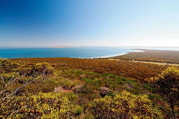
As you enter the Memory Cove Wilderness Protection Area you’ll find yourself surrounded by coastal white mallee, dryland tea-tree, coast beard-heath and drooping sheoaks. This vegetation provides habitat for a wide variety of bird species, including the southern emu-wren and the rare western whipbird.
Travelling through this wilderness, you’ll notice how the vegetation changes depending on the availability of water, soil type and protection from salt spray and strong winds.
The track winds itself up and down the hills, with steep drop-offs and deep wheel ruts in several sections. The views of the coastline and the pounding surf of the Southern Ocean are simply spectacular, especially when you are the only people to enjoy this awesome landscape.
A track on the right leads to a cliff top with commanding views of Curta Rocks, Cape Tournefort and the Twin Pinnacles at Cape Wiles on Whaler’s Way. Curta Rocks is a significant nesting area for sea birds and a haul out area for New Zealand fur seals and Australian sea lions. During the winter months it is also the ideal location to spot whales.
A little further down the track you might be able to spot Neptune Islands Conservation Park, depending on how clear it is. These islands contain the largest New Zealand fur seal colony in South Australia and are frequented by the great white shark. The island with the lighthouse closest to the mainland is Williams Island and to its right is the tall headland of West Point.
Suddenly the track flattens out and you find yourself in a wide open plain. From the 1840s until 1957 this bit of land was grazed and cropped as part of the West Point Lease. Stock were watered from springs and soaks near the granite outcrops and along the cliff tops fronting Sleaford Bay. Horse teams and cattle were also pastured at West Point but today this area provides the ideal grazing for western grey kangaroos.
CAPE CATASTROPHE
As you approach the southern tip of the Memory Cove Wilderness Protection Area, the views become even more spectacular. Cape Catastrophe comes into view, as do Thistle Island and the bay below. The lookout is known locally as ‘Ivy’s Leap’ after a local tour operator. The handbrake of the tour vehicle failed and it rolled forward, plunging over the cliff. Luckily no one was in it at the time.
At last you’ve reached Memory Cove, and you’re in for an unforgettable wilderness experience. The plaque at the picnic area reveals the sad history of this beautiful cove. British explorer Matthew Flinders surveyed the rugged coastline of the lower Eyre Peninsula in 1802 in HMS Investigator. On Sunday, February 21, 1802, Flinders anchored adjacent to Thistle Island. Desperate to find water he sent a crew of eight men to the mainland in a cutter but they never returned. The wreck was located the next morning but none of the bodies were recovered. Flinders named the prominent features in this area after his lost crewmen: Taylor, Grindal, Little, Lewis, Hopkins, Smith, Thistle and Williams. Cape ‘C’ was renamed Cape Catastrophe and the little cove named Memory Cove.
Today, Memory Cove is a magnificent bay, away from the crowds and the hustle and bustle of the city. This is a unique wilderness destination which will have you coming back for more – take my word for it!
The full feature appears in Caravan World #560 2017. Subscribe today for the latest caravan reviews and news every month!


