
How's the Serenity?
The delightfully-named Hibiscus Coast is a tropical paradise just north of Mackay. Its most prominent feature is Cape Hillsborough, a spectacular promontory jutting into the sparkling, turquoise waters of the Coral Sea. Most of the cape is conserved by a 1000ha national park, while the surrounding sea is part of the Great Barrier Reef Coast Marine Park.
To the west, the granite peaks of Mt Ossa and Mt Jukes rise from a lowland patchwork of sugarcane plantations and grazing pastures that are gradually succumbing to urban development. In the northern lee of the cape, the sleepy holiday towns of Seaforth, Halliday Bay and Ball Bay recline along sandy beaches separated by forested headlands.
GEOGRAPHIC HISTORY
The rock underlying Cape Hillsborough was laid down as the bed of a shallow sea and contains fossils of turtles and crocodiles. Over this ancient limestone plate a series of volcanic eruptions about 32 million years ago spewed lava in a pyroclastic turmoil forming cones, such as Pinnacle Rock, and contorted hills with caves and overhangs.
Erosion has scoured this striking landscape to produce the distinctive grey, fine-grained beaches of Casuarina and Beachcombers Bays and masses of colourful rhyolite boulders at the base of rocky headlands. Low tide exposes a stony causeway projecting from the cape’s eastern tip to Wedge Island and its fringing coral reef.
Rising almost 300m, the park’s rugged terrain is covered by many different plant communities, with more than 500 species unique to the region. Ironbark and brushbox woodlands are widespread across the central hills and rainforest thickets grow on the slopes and gullies below the plateau.
Forests of tall hoop pines cover the eastern and northern ridges almost to the highwater line, while the exposed beachfronts are backed by she-oak, acacia and banksia. West of the main visitor area, extensive alluvial wetlands support paperbark forests that morph to mangroves on salt pans and intertidal mudflats.
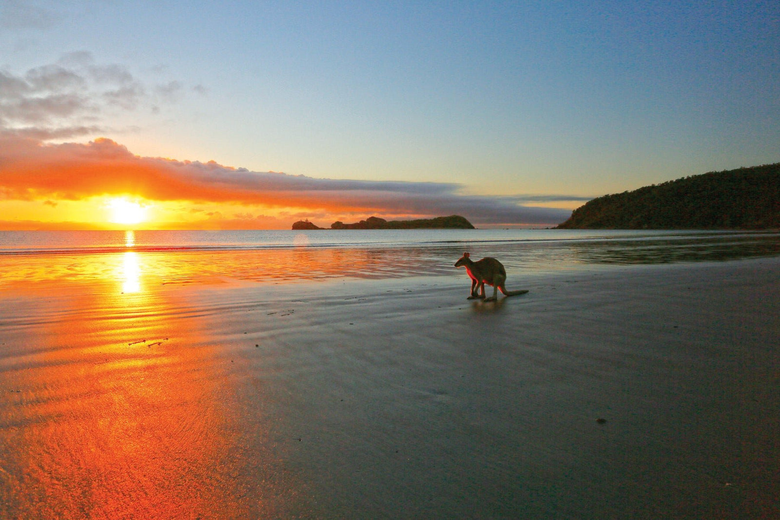
These diverse habitats support a rich abundance of wildlife – 167 species of birds, 27 mammals, 42 reptiles and 11 amphibians. Of the several species of kangaroos and wallabies found in the park, the most common are the agile and pretty-face wallabies which gather on the beaches at sunrise and sundown, creating a truly iconic Australian experience that’s not to be missed. The coastal caves provide roosts for bats, including one of only four known colonies of vulnerable ghost bats in Queensland.
Concentrated in the rainforest communities, the park’s tropical birdlife includes such colourful specimens as the orange-footed scrubfowl, imperial pigeons, paradise kingfishers and rufous owls. Some are migratory and many reach the southern limit of their natural distribution at the cape.
On the broad beaches, flatback turtles lay their eggs in secluded rookeries and bubbler crabs leave stippled patterns in the sand at low tide. Many sea creatures shelter in the tidal rock pools, and the mudflats, washed by a 6-metre tide, are important habitats for crabs and breeding grounds for fish.
INDIGENOUS TRADITIONS
The Hibiscus Coast and hinterland as far west as the Clarke and Connors Ranges are the traditional lands of the Yuibera (Yuwi) Aboriginal people, who occupied them for countless generations before European settlement. They made extensive use of the area’s rich natural resources, physical evidence of which exists today in the form of fish traps and numerous middens of shellfish that were collected from nearby mangroves and roasted over open fires. Other signs of their occupation include fireplaces, pieces of ochre and artefacts such as axe heads and hammer stones.
An Aboriginal mission was established on a 5700ha reserve in 1876, within the present-day national park, but was closed nine years later and the community transferred to Rockhampton. Despite displacement from their homelands, the Yuibera maintain a strong spiritual connection with Cape Hillsborough and are active in the park’s management with Queensland Parks and Wildlife Service.
Two walks have been developed that present Yuibera culture and the traditional lifestyle they enjoyed on the cape. The award-winning Diversity Boardwalk is an easy 1.2km meander through melaleuca woodland, a mangrove community, open eucalypt forest and vine thickets. Interpretive panels describe the flora and fauna and explain the cultural significance of these diverse environments to the Yuibera. The self-guided Yuibera Plant Trail (1.2km return) explores a pocket of rainforest in Hidden Valley and identifies numerous plants that were used by the Yuibera for various purposes, such as food, huts and canoes, medicines, baskets, wooden implements and weapons.
COLONIALISTS AND FOSSICKERS
Explorer James Cook was the first European to reach the cape in June 1770. He noted the prominent nature of the headland and named it after the Earl of Hillsborough, a member of the English and Irish parliaments and Secretary of State for the American colonies.
Settlement of the area began in 1867 when settlers McBryde and Finlayson selected 4000ha near the cape for breeding cattle. Other farms were established soon after. The area was also known to attract fossickers seeking semi-precious gemstones like topaz, opalised ‘thunder eggs’ (geodes of agate containing crystals) and fossils.
In the early 1950s, the Risley family were granted a 2.5-hectare freehold behind the beach on Casuarina Bay. A residence was prefabricated in Mackay and transported to the site by boat. An access road was cleared through the bush and a resort developed with holiday units, a caravan park and shop, supplied with running water (from a spring on the hill), electricity and telephone. The Risleys sold the resort in 1975 but, when the national park was gazetted in 1985, the freehold was preserved for the continued operation of the Cape Hillsborough Nature Tourist Park.
BACK TO NATURE
Adjacent to the national park’s main day-use area, the resort is the hub of tourist activity on Cape Hillsborough. Each year, more than 180,000 visitors are attracted to the cape for nature-based recreation, with many extending their experience of its tropical environment by staying at the privately-owned resort or the national park camping area at Smalleys Beach. Commercial overnight accommodation is also provided at nearby Halliday Bay and Seaforth.
The day-use area is established in a natural bush setting, with toilets, water, grassy open spaces, picnic tables, gas barbecues and interpretive signs. It’s close to Casuarina Beach for walking and swimming, and a boat ramp enables tinnies and jet skis to be launched across the beach into the marine park for fishing and water sports. (Zoning regulations control recreational activities in the marine park and maps are available from government agencies, bait and tackle shops and online.)
The trail heads for Beachcomber Cove, Anderson Point and Wedge Island are accessed from the picnic area and a short dirt road (not recommended for 2WD vehicles) leads from the picnic area to the start of the Yuibera Plant Trail in Hidden Valley.
The 2.2km Beachcomber Cove Track starts from the northern end of the picnic area and passes through open eucalypt forest and rainforest with hoop pines, ferns and vines. During the cooler months walkers may be engulfed by native butterflies, and in the wet season several freshwater springs feed Cascade Creek which falls to a swimming hole.
A lookout at the top of the ridge provides scenic views of the cove and surrounding hills. At low tide, you can return to the picnic area along the beach, otherwise you’ll need to retrace your steps along the track.
The popular Andrews Point Track starts at the southern end of Casuarina Beach and climbs numerous steps through cool rainforest before opening to more exposed eucalypt forest along the top of the ridge. At five vantage points, lookouts deliver spectacular views of the cape’s beaches, the Whitsunday Islands to the north and the Coral Sea, where whales can be spotted during migration season.
The track debouches onto a beach opposite Wedge Island. At low tide you can return to the picnic area along the beach, to complete a 2.8km circuit, or proceed across the stony causeway to the island and Orchid Rock, which is a blaze of colour with golden orchids in late September. At high tide, you’ll need to retrace the track across the ridge (5.2km return).
This scenic national park is readily accessible from the major population centre of Mackay, only 50km to the south. Yet, its rugged geological formations, secluded beaches and tropical rainforests imbue it with a feeling of remoteness and serenity that sets it apart from the mainstream tourist destinations in this part of Queensland. There’s plenty to see and do here, and a range of overnight accommodation enables visitors to stay a while and enjoy it.


