Stone Country
Australia’s ‘Top End’ is a vaguely defined region encompassing a section of the Northern Territory north of Katherine. A large part of it (97,000sqkm) is Arnhem Land, bordering the Arafura Sea from the base of the Cobourg Peninsula in the west to the Gove Peninsula in the east. Most maps define it as a bland, beige-coloured patch, suggesting there is little adventure to be found there. The reality is very different.
Often considered Australia’s last frontier, Arnhem Land is a wild and untamed landscape, a spectacular mosaic of rugged coastlines dotted with remote islands, towering sandstone escarpments and sprawling savannah woodlands threaded by pristine rivers. These are habitats for abundant wildlife; it’s one of the richest and most diverse bio-regions on the planet. The region’s small human population is predominantly Aboriginal and their ancestors emerged from the Dreamtime to occupy this land for more than 50,000 years and pass on a culture that remains largely unaffected by European influence.
Arnhem Land’s relative isolation is part of its appeal, attracting more than 100,000 visitors in 2019. Not lacking for motivation, the opportunity for us to go there was provided by friends who lived in Gunbalanya, and a couple of mates from Darwin. The ensuing sojourn revealed the magnificent landscape of Stone Country, the shimmering splendour of the Arafura Sea and the ancient Indigenous culture that enriches it all.
CROSSING THE THRESHOLD
We spent a couple of days in Jabiru stocking up and obtaining our transit permit from the local Northern Land Council office, before joining the four-vehicle convoy at Cahills Crossing on the East Alligator River. The river marks the boundary of West Arnhem Land and it can be a formidable obstacle at any time of year — a swollen, brown torrent in the wet season and a seven-metre tide in the dry season make the concrete causeway impassable until the river ebbs.
This is one of three rivers called Alligator, which together drain one of the largest catchments in the Northern Territory. They are perennial, flowing even during the dry season, and their diverse bio-regions support abundant plant and animal species. For thousands of years before Europeans, Aboriginal people crossed the three Alligators on a major trade and communication route. Today, the crossing on the East Alligator bears the name of Patrick ‘Paddy’ Cahill, one of the area’s early settlers.
Arriving at the crossing, we found the tide too high to safely navigate, so we parked our motley collection of 4WDs towing tinnies and trailers and grabbed a bite to eat at the adjacent Border Store. From a vantage point overlooking the river we watched 3m ‘salties’ patrolling the muddy waters until it was time to mount up and proceed. As we crossed, we were astounded to see anglers along its edges pulling in large barramundi under the watchful gaze of the saurian predators lurking nearby.
STONE COUNTRY
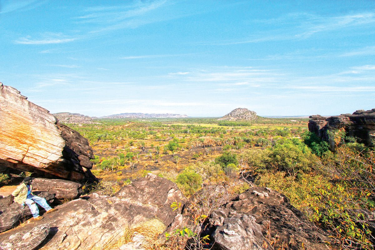
Beyond the crossing, a red dirt road traced a scenic 16km route to the Aboriginal community of Gunbalanya. This is ‘Stone Country’, so named for its proximity to a vast sandstone plateau formed about 2,000 million years ago. Millennia of weathering and erosion have carved the plateau into gorges, crevasses and colourful craggy outcrops. Its 500km escarpment of vertical cliffs crumbles in long talus slopes to savannah plains that merge in tidal mudflats on the shore of the Arafura Sea.
The region’s temperatures hover in the mid-30s and a north-west monsoon dumps up to 1,600mm of rain during the November to March wet season. Swollen by torrential rain, the rivers overflow onto floodplains to form wetlands populated by huge numbers of waterfowl and aquatic wildlife. During the dry season in which little to no rain falls, sprawling wetlands recede to isolated billabongs, lush savannah grasslands shrivel to straw and animals congregate around residual waterholes.
These fluctuating seasons nurture one of the richest biological regions in Australia — about 1,500 species of plants including mangrove, monsoon forest, tropical grassland and woodland; more than one-third of the continent’s bird species; and 46 species of native freshwater fish.
ABORIGINAL HERITAGE
Aboriginal people have lived in Arnhem Land for at least 50,000 years — the Yolgnu in the east and the Gagudju and Gunwinggu in the west. While having similar forms of social organisation and holding many common religious beliefs and tribal customs, these groups speak distinct languages and maintain strong cultural traditions.
In West Arnhem Land, the clans hunted and foraged on the fertile plains and billabongs around the East Alligator River. During the wet season, they retreated to higher ground, camping among the plateau’s caves and rock shelters. Here, they created innumerable ochre paintings at more than 1,500 sites which have survived to provide a magnificent record of their occupation. The rock art on Injalak Hill, near Gunbalanya, has been dated to 8,000 years old and features people, animals, creation spirits and ancestor beings from the Dreamtime.
The earliest evidence of Aboriginal contact with foreigners dates to the mid-1700s when Makassan fishermen from Sulawesi (part of modern-day Indonesia) came in search of trepang (sea cucumber), a highly prized delicacy in China. While they did not settle, the Makassans exchanged goods such as cloth, tobacco, knives and rice for the right to harvest trepang from the coastal waters and employ local labour. Makassar pidgin became a lingua franca along the north coast among several Aboriginal groups who were brought into greater contact with each other by the seafaring Makassans.
Arnhem Land was declared an Aboriginal Reserve in 1931 and, at 97,000sqkm, it is one of the largest areas of Indigenous-owned land in Australia. In the 1980s, many Aboriginal groups moved away from missions and towns to small settlements on their traditional clan lands. This so-called homeland or outstation movement stimulated an increase in ceremonial and traditional activity, reflected in the production of art for domestic and international markets. Today, Indigenous Australians constitute three-quarters of the region’s estimated population of 16,000, the majority of whom live on the outstations.
EUROPEAN HISTORY
The region’s name was bestowed by Dutch East India Company captain William van Colster in 1623 after his ship, the Arnhem, and the eponymous city in the Netherlands. Phillip Parker King, the first English navigator to enter the Gulf of Carpentaria, made extensive surveys of the Arnhem coast between 1818—1822. He named the three Alligator Rivers in the mistaken belief that the numerous crocodiles he saw were alligators.
Ludwig Leichhardt was the first overland explorer to visit the area in 1845 en route to Port Essington, followed by John McDouall Stuart in 1862. European settlement of the area was slow and sporadic due to its remoteness, extreme climate and the incidence of tropical illness among early pioneers. After tentative attempts by the British to settle on Melville Island in 1824 and on the nearby mainland in the following years, the first permanent settlement, Palmerston (later Darwin), was founded in 1869.
Commercial hunting of water buffalo for hides and horns began in the 1880s and continued until the development of synthetic substitutes in the 1950s. Crocodile hunting was also conducted until it was made illegal in 1971. Paddy Cahill arrived as a buffalo shooter in the 1890s and, with the assistance of local Aboriginals, established a produce farm and cattle station at Oenpelli in 1906. The Church of England Missionary Society established a mission on the station in 1925. It remained a mission with a church, school, dispensary and general store until 1975, when it was taken over by an Aboriginal town council and the name was changed to Gunbalanya.
GUNBALANYA TODAY
Gunbalanya stands at the edge of a beautiful lagoon, with Injalak Hill looming in the background. The town has a population of about 2,000, predominantly Gunwinggu people, and is administered by the West Arnhem Land Regional Council. The Council provides a range of essential services including utilities and housing, sport and recreation facilities and employment programs. There is also a health clinic, supermarket, service station, school and police station. It is the home of the Injalak Arts and Crafts Centre, which is a hub for Aboriginal artists in West Arnhem Land.
THE CONVOY CONTINUES
One thing Gunbalanya doesn’t have is a camping area, or indeed any other form of accommodation, for travellers. (The nearest campground is Merli in Kakadu NP). However, our friends kindly made their driveway available for our camper trailers overnight while we regrouped for the next leg to the coast. Leaving our hosts to their trip preparations, we strolled to the nearby lagoon, which proved to be an aquatic paradise. Although well into the dry season, this picturesque lake was brimming with water and teeming with fish. Hundreds of birds wheeled overhead, glided across the water and stalked prey in the lily-choked shoreline.
Next morning, the convoy set off northwards to Wiligi Outstation, 160km away on the coast. The road was unsealed all the way and corrugated in parts, with an occasional sharp corner or shallow creek crossing to keep us on our guard. We also had to be alert for cattle, buffalo and wild ponies that sometimes stray onto the road. But the track was in surprisingly good condition, considering it is submerged for several months of the year and only intermittently sees a grader. After about two hours we crossed the Wellington Range and paused for smoko on a beach at Aurari Bay, before pressing on through Murgenella (Wauk) to Wiligi at the neck of the Cobourg Peninsula.
This remote outstation is perched on a low headland with spectacular views across Mountnorris Bay to Copeland Island, a short distance offshore. On arrival, we were greeted by Reuben Cooper, the senior traditional landowner. Reuben is an Iwaidja-speaking member of the Muran clan, whose family and forebears have lived on this country for many generations. In the early 1900s, his grandfather built boats from locally-milled cypress pine, and the remains of the mill can still be seen today. After a brief absence when hostilities threatened the Top End during the Second World War, Reuben returned with his wife, Dawn, and established a home on the present site where they have lived since 1999.
We were directed to a spacious camping area dotted with large trees that provided welcome shade for our camp chairs. The facilities were basic with cold showers (you don’t need hot ones up here) and composting toilets (that have since been upgraded to flushing ones), water and firewood. These were more than adequate for our needs and perfectly in harmony with the unspoilt paradise around us.
We set up camp on a grassy berm overlooking the beach, where a gentle shore break belied the ferocity of monsoonal storms that lash this coastline, as evidenced by the wave-worn rocks and ragged sand cliffs. Today, the ocean beckoned as a blissful release from the unrelenting afternoon heat but, as tempting as that prospect was, swimming here is not recommended because of the salties, sharks and stingers.
Fortunately, local creeks, reefs and open waters teem with fish of many kinds, including barramundi, red emperor, Spanish mackerel and coral trout, and mud crabs and oysters may be garnered from the nearby mangroves and estuaries at low tide. The anglers had two boats to motor about in, keeping us happily occupied for the duration of our stay. Even when the fish weren’t biting, it was wonderfully relaxing to just sit back and watch for dolphins and turtles gliding past on the gentle ocean swells. For land-based leisure, we combed the golden beachfront, went birdwatching in nearby forests and watched blazing sunsets over the bay. Those with a taste for more remote adventure, and 4WD vehicles, can head west into nearby Garig Gunak Barlu National Park, which covers the entire Cobourg Peninsula (transit and camping fees apply).
After five hot, halcyon days in our seaside camp, our supplies were low, and it was time to head back to Gunbalanya. Rather than passing through, we stayed a couple of days to visit some local attractions. Opened in 1989, the Injalak Arts & Crafts Centre is a cooperative with more than 200 artists from the area who produce traditional paintings on bark and paper, and make didgeridoos, pandanus weavings and screen-printed fabrics. At the Centre, we browsed numerous works and would have bought if not for the lack of space in our rigs.
We also took a tour of the rock paintings on Injalak Hill, guided by a diminutive local elder named Simon. With a spriteliness belying his apparent age, Simon led us up a rocky trail that rose steeply through the scree slopes to overhanging galleries among the crags. As we paused to catch our breath, Simon explained the Dreamtime stories that inspired the colourful artwork. During the next three hours, we clambered through several more galleries before emerging onto a rock platform with panoramic views of Gunbalanya, the lagoon and Stone Country stretching away to the distant escarpment — a fitting finale to our memorable sojourn in West Arnhem Land.
FAST FACTS
- Gunbalanya is 260km east of Darwin by road, accessed via Cahills Crossing over the East Alligator River at low tide. Wiligi Outstation is a further 160km north of Gunbalanya on Mountnorris Bay.
- Roads to Cahills Crossing are sealed; within Arnhem Land roads are unsealed and corrugated in parts, navigable by high-clearance vehicles and vans during the dry season (April-October) but impassable during the wet season. Travellers should be well equipped with a first-aid kit and spare tyres.
- The last major town for fuel, supplies and accommodation is Jabiru, 60km south-west of Gunbalanya.
- Unpowered camping suitable for caravans and camper trailers available with basic facilities at Merl campground in Kakadu NP near Cahills Crossing — adults $15/night, children $7.50/night, families $38/night.
- The Border Store at Cahills Crossing provides takeaway food, meals at the cafe, some basic supplies but no fuel.
- Gunbalanya has no camping or accommodation for visitors. The general store has fuel (diesel and Opal unleaded) and a limited range of supplies.
- No fuel or supplies are available at Wiligi and visitors must be self-sufficient in everything but water and firewood.
- Accommodation at Wiligi is available in cabins with fully equipped kitchen, eco-tents with a shared kitchen/dining area, and a log cabin, all bedding and linen is supplied, fees $275/night; unpowered camping suitable for high-clearance caravans and camper trailers with drinking water, flush toilets and cold showers, fees $55/person/night.
- Activities at Wiligi include boating, fishing, birdwatching, photography, beachcombing and crabbing. Swimming is not recommended due to the presence of estuarine crocodiles, sharks and marine stingers.
- Permits to enter Arnhem Land may be obtained from the Northern Land Council or through Reuben Cooper at Wiligi Outstation.
- Alcohol may be carried but not consumed while travelling through Arnhem Land but may be consumed in Wiligi. No unleaded fuel other than Opal is permitted in Gunbalanya or other communities.