




Upper Gascoyne: Almighty Rock Stars
Western Australia’s so-called fruit bowl, Carnarvon, is a rather unique stopover. Shaggy banana plantations, heritage NASA satellite dishes and a larger-than-life ‘Humpty Dumpty’ are the coastal town’s must-sees. (An honourable mention goes to Carnarvon’s very own ‘Big Banana’, not to be confused with the one in Coffs Harbour, NSW.) Keep driving north of Carnarvon, and no doubt you’ll want to spend a decent chunk of time along the coast, ticking off bucket list adventures and snorkelling with manta rays or whale sharks in Coral Bay or Exmouth. But before you track further north along the coast and bid farewell to Carnarvon, bear a sharp right.
A two-hour drive (172km) east along the sealed Carnarvon-Mullewa Road, you’ll find Gascoyne Junction. As the name suggests, this remote hamlet on Yinggarda country is the meeting point of the Gascoyne and Lyons rivers, and the gateway to the Upper Gascoyne region. Notable highlights (and quite frankly, hard to miss) include Kennedy Range National Park and Mount Augustus: the world’s largest monocline. More on their immense outback presence later. For now, my winter adventure at the crossroads.

All roads lead to Gascoyne Junction
A 1962 Cessna VH-DMT plane permanently hovers above the town’s welcome sign at the corner of Two Rivers Memorial Park. Donated by local pastoralist Laurie Bain, who used it to aerially muster cattle for three decades, it’s a fitting welcome to this part of the country.
Plane aside, there are minimal amenities in the ‘oasis in the outback’, home to roughly 60 residents. In December 2010, the region was devastated by a ‘once in a century’ flooding event; the Gascoyne River peaked at 7.8m at Nine Mile Bridge gauging station. The town’s petrol station and 100-year-old pub were both swept away; the shade structure over the pumps was the only thing left standing.
Since then, the resilient red-dirt town has bounced back. The pub was rebuilt, the Killili Bridge was erected over the Gascoyne River and parklands were revitalised with an amphitheatre and a striking war memorial featuring galloping horses, which is conveniently located near pull-in picnic bays. Things get loud in the usually quiet town every fourth Saturday of each month, from May to September, with the shire hosting Music in the Park: a free, family-friendly concert in the amphitheatre.
For the remainder of the year, the main hubs of activity in this 2023 National Tidy Towns-winning community are the Gascoyne Junction Community Resource Centre (CRC) and the pub. Before venturing beyond Gascoyne Junction, it’s worth dropping into the CRC for the latest live road condition updates and closures.
Maintaining good roads is something the Shire of Upper Gascoyne prides itself on, with nearly 2000km of unsealed highways (alongside 100km of sealed roads) and a meagre 18 traffic lights in an area covering some 57,809 square kilometres. To put it into perspective, the region covers 80 per cent of Tasmania or a quarter of Victoria. That’s a lot of networking to support neighbouring industries: mining, pastoral and desert merino wool.
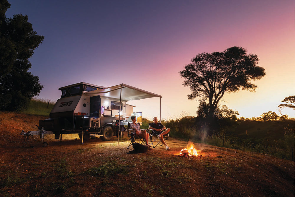
While a sleepy town, Gascoyne Junction’s sole caravan park — the Junction Pub and Tourist Park — is worth pulling into for a night or two before heading further afield. The modern caravan park offers 27 caravan sites (10 powered with concrete slabs, seven powered and six unpowered grass sites and four powered concrete ensuite sites). There’s an ablution block, washing lines, a small playground and a camp kitchen all centrally located, mere metres from each site. Land unchanged for eons backs the park and offers uninterrupted views of the Kennedy Range National Park in the distance. Sunsets here are stunners, with the horizon a vibrant orange before the sky transforms into soft lavender and peach pastels. Yet, after dark is when the town truly shines.
Gascoyne Junction is an official Astrotourism town, renowned for its unpolluted dark skies. You don’t have to venture too far to get a glimpse of the star-studded line-up of the Milky Way. A five-minute drive from the town centre is the Waterhole. The picnic spot along the Gascoyne River is a local favourite for observing the bright silver glow of the Milky Way (and is also a renowned birdwatching site). Cosmo crazy? The shire also hosts regular stargazing events with telescopes provided at the town oval. The dedicated spot also features a star wheel for beginner astronomers.
Once you’ve had your fill of galaxies far away, it’s time to head to the pub. During my visit there was a handful of locals milling around the refurbished bar, with a family seated by the roaring drum firepit outside. It felt like entering someone’s backyard, complete with a fenced-off pool nearby and casual high-top tables. Typical pub grub, prepared by caravan park managers Daniel Bond and Evangelista ‘Lista’ Cartwright, locals told me, does not disappoint. Prices are reasonable, with portion sizes generous. My reef and surf dish (grilled red emperor fillet and prawns) swum in freshly made garlic sauce and was served alongside chips and salad. From my first night on I made excuses to visit for another three meals (the wagyu burger also deserves praise).

Keep the Gascoyne’s red dirt and sand where it belongs: outside. Muk Mat provides a practical barrier at your caravan, camper or vehicle door, helping keep your setup cleaner wherever the road takes you. Available in a range of sizes and colours, it’s an essential addition to any Western Australian adventure.
Half a day’s hike
It’s a 60km journey north on Ullawara Road to reach Kennedy Range National Park. On the hour-long drive, I passed rose-pink clay pans, the odd white cow and boundless desert sparsely dotted with shrubs and healthy green spinifex. The most enthralling sight was three wedge-tailed eagles feasting on the remains of a kangaroo in the middle of the road. It was then I knew I was well and truly in the wild west.
Known as Mundatharda in the local Yinggarda language, Kennedy Range National Park extends 75km in length and between 12–25km wide. Approaching the range along Lyons River Road, it appears like one big barrier. The remote sandstone plateau soars up to 100m above the ochre expanse. Within it you can explore gorges millions of years in the making, rocks formed from ancient seas and appreciate the low-lying, drought-resistant vegetation and the sporadic trees (mallee, wattle, contorted sandalwood) that encroach on the foothills.
I spent half a day under overhangs, roaming around the giant mesa on foot. The most prominent attraction, Honeycomb Gorge, includes a moderate 600m return hike. The short track passes giant boulders before arriving at a cliff face resembling that of its namesake: a wall punctured with faux breezeblocks sculptured by nature. As it is a culturally significant site for the Yinggarda people, touching or photographing the geological wonder is prohibited.
However, similar molten-like rock formations can be found at a nearby trail, Temple Gorge, which is only a short stroll from the same-name campground (caravan-friendly, bookings required). You’ll spot a natural pyramid at the fork of the rocky trail, with two ways to go: left for a moderate path or right for a difficult road ahead. Bearing in mind the rising heat, I took the easy route, which ventures a little bit further in the gorge (150m) until I was met with an ‘End of Trail’ sign. It was a spectacularly short and sweet walk. The longer and more challenging route is a 2km return track.
Across both Kennedy Range and Mount Augustus national parks, hiking signage appears to overestimate the timings to complete each hike. Still, it’s better to plan for the long haul. These hikes can be dangerous in scorching temperatures, especially if one is ill-prepared. Meanwhile, all trails — including those at Mount Augustus — have sufficient markers.

The biggest rock in the world
While you can drive straight from Kennedy Range to Mount Augustus along Ullawarra Road (260km), I returned to Gascoyne Junction for the night. Local shire member Ainsley Hardie accompanied me on the big drive the next day, travelling 330km on the mostly unsealed Cobra Creek Road to reach Western Australia’s sleeping giant, with roads in great condition.
Mount Augustus (known as Burringurrah to Traditional Owners) draws you in like a magnet after passing endless plains. Twice the size of Uluru, Mount Augustus is officially the world’s largest rock, its sandstone and quartzite mass rising 717m and spanning 8km. Its remoteness in the Upper Gascoyne region is perhaps why it does not get the airtime it deserves — but it’s well worth the trek to see Australia’s biggest rock star.
At the foothills of the monocline is Mt Augustus Tourist Park, truly an oasis in the outback with patches of green grass and towering palm trees. Here, the sole tourist hub has a tavern, petrol pump, self-contained cabins and large powered and unpowered sites with adequate space in between. There’s unfortunately minimal shade at the campsites. I woke up early to see the rock slowly morph into shades of red at sunrise, then watch as shadows slowly disappeared over it, the sun eventually illuminating the rockface in a striking deep orange.
Right at the caravan park gate, before the big rock, volunteer hosts provide hiking trail information under a marquee. There are eight hiking trails along the 45km 2WD unsealed Loop Trail, with walking tracks ranging from short hikes to extreme half-day adventures.

We took it easy with a stop-start adventure along the Loop Trail, completing all short-to-moderate hikes. While all the hikes offer something different in terms of landscape and art, the moderate 650m Flintstone Rock Trail (Beedoboondu) is a standout. After viewing its ancient Aboriginal petroglyphs shaded beneath boulders, we clambered 10m up the rocky gully for a better view of the landscape and distant hills. The track forms part of the full-day Mount Augustus Summit Trail (12km return), which is recommended only for serious hikers and should be started no later than just after sunrise.
Another highlight is the Mundee Trail, which is part of the Petroglyph Trail. The short 200m trail features numerous ancient petroglyphs alongside nature’s artwork: lines of glittery quartz in mosaic patterns are embedded in its rock caves and faces. It’s hard to be disappointed by this inland detour, as day and night, the Upper Gascoyne sparkles.
Please note: There is no phone reception at Kennedy Range or Mount Augustus national parks.
When the Gascoyne winds pick up, keep your awning secure with TieGear. Its durable guy ropes and shock-absorbing springs help maintain tension while reducing sudden strain caused by strong gusts—giving your campsite a safer, steadier setup wherever your WA adventure takes you.

Contact info
Junction Pub Tourist Park
4 Viveash Way
Gascoyne Junction WA 6705
P: 08 9943 0868
E: info@junctiontouristpark.com
Kennedy Range National Park
P: 08 9948 2226
W: exploreparks.dbca.wa.gov.au/park/kennedy-range-national-park
Mount Augustus National Park
P: 08 9948 2226
W: exploreparks.dbca.wa.gov.au/park/mount-augustus-national-park
Mt Augustus Tourist Park
Cobra-Mount Augustus Road
East Lyons River WA 6705
P: 08 9943 0527
E: mtaugustustouristpark@skymesh.com.au
Shire of Upper Gascoyne
P: 08 9943 0988
E: admin@uppergascoyne.wa.gov.au
Temple Gorge Campground
Kennedy Range National Park
W: exploreparks.dbca.wa.gov.au/site/temple-gorge-campground
To discover more self-drive trails in the broader Gascoyne Murchison region, visit outbackpathways.com

Upper Gascoyne Region: WA's Almighty Rock Stars