Fitzgerald River National Park, WA

The Fitzgerald River National Park embraces 3300sq km of unspoiled wilderness on a stretch of rugged coastline between the towns of Bremer Bay and Hopetoun, 420km south-east of Perth.
Within its boundaries are nearly 20 per cent of the state’s plant species, many found nowhere else, and it is home to more kinds of animals than any other reserve in southwestern Australia. These outstanding natural features have been recognised by UNESCO in designating it as a World Biosphere Reserve.
TEEMING WITH LIFE
The park straddles the incised valleys of four intermittent rivers — the Gairdner, Fitzgerald, Hamersley and Phillips — which flow mainly during winter and spring from northern uplands to the coast. Each of them cuts through dramatic gorges and steep-sided valleys that end abruptly at inlets, of which Hamersley Inlet is the longest and deepest.
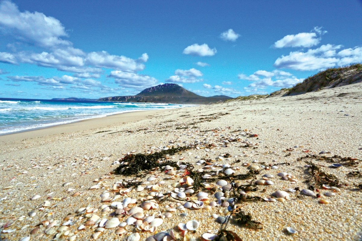
Undulating sandplains blanket the central and western parts of the park, dotted with numerous swamps and shallow saline lakes. Out of these rolling plains rises a range of rugged peaks that dominate the coastal fringe overlooking the Southern Ocean. These distinctive landforms are made of sedimentary rocks laid down about 1300 million years ago, transformed by intense heat and pressure into hard, white quartzite and eroded to a jagged ridge resembling the spine of a giant sleeping dragon.
When Matthew Flinders sailed along the coast in 1802 he referred to this series of peaks as ‘barren hills’, naming West, Mid and East Mount Barren, unaware of the unique and abundant plants and wildlife that flourish among them.
East Mount Barren (450m) guards the eastern entrance of the national park and its distinctive bulk can be seen clearly on the approach from Hopetoun. The carpark on its western side is the trailhead for a moderately difficult walk (2.6km return) to the summit, where hikers are rewarded for their effort by a spectacular view over the central park and the ranges stretching west along the coast.
A short walk from the carpark off Hamersley Drive leads to the Barrens Lookout, with a view of the coastline back to Hopetoun. The climb to West Mount Barren summit (372m) is shorter (1.7km return) but equally rewarding for its panoramic views over the western peaks and the rolling plains to Gordon Inlet, Trigelow Beach and Point Ann.
Most of the park’s coastline consists of broad sandy bays separated by rocky headlands and steep cliffs. The vast, moody Southern Ocean alternately pounds these ancient ramparts or benignly bathes the stunning white-sand beaches in turquoise tranquility. Some beaches are sheltered and others are exposed and wind-swept; all are magnificent strands of coastal scenery.
BLOOMING DIVERSITY
A Mediterranean climate of cool wet winters and hot dry summers nurtures an amazingly complex and diverse array of plant communities across the park’s nutrient-poor soils — woodlands of eucalypts, melaleucas and callistemons; shrublands of mallee, banksias, grevilleas, hakeas and dryandras; dense thickets of heath with myrtles, daisies, peas and orchids; grasses on the open, sandy plains; sedges along the rivers and swamps; PLUS five families of fern and 87 of plants that collectively flower all year round and peak in a truly spectacular display between July and December. In all, more than 1800 plant species have been recorded here, of which 250 are rare and 75 are found only within the park.
While not as rich as its floral diversity, the range of animal species inhabiting the park is pretty impressive — 22 mammals, 41 reptiles, 12 frogs and more than 200 birds. Ten of these species are rare or endangered, including two that were once thought to be extinct. Migratory birds find refuge in the wetland and coastal regions, and species that temporarily inhabit the park include the white-bellied sea eagle, Pacific swift and the Caspian tern. Whales, and dolphins are frequent visitors to the park’s coastal waters, and seals and seal lions occasionally haul out on secluded tidal platforms.
CULTURAL HUB
The Fitzgerald River National Park lies within the traditional lands of the Wudjari and Njunga Aboriginal people, who are members of the larger Noongar nation comprising 14 language groups across the southwest corner of Western Australia. Archaeological evidence establishes that Noongar people have lived in this area for at least 45,000 years.
The Noongar occupied and travelled across the park’s landscape in family groups following the seasonal availability of food and fresh water. They hunted a variety of game, speared and trapped seafood, and gathered seeds and plants for food and medicines.
Despite considerable disconnection from their Country after European settlement, Noongar people retain a strong sense of identity and a deep spiritual bond with their ancestral lands. They continue to care for the national park and are actively engaged in preserving its rich cultural and natural heritage.
EUROPEAN HISTORY
In 1802 Matthew Flinders charted the rugged coastline in HMS Investigator. By the 1820s, British, French and American whalers and sealers were hunting the Southern Ocean and islands off the Western Australian coast, using Bremer Bay as a stopover and Albany as a re-supply base. After traversing the Nullarbor Plain, explorer Edward Eyre and his Aboriginal companion, Wylie, passed through the area in 1841 on their way to Albany. Eyre was distinctly unimpressed with what he saw, describing the area as “a wretched and arid looking country”. (In fairness, he didn’t see it during the wildflower season.)
Pastoralism in the Fitzgerald region began in 1850 when John Hassell acquired the Jerramungup pastoral lease and John Wellstead settled at Bremer Bay. Wellstead squatted at Quaalup, building a homestead there in 1858 as an outstation for grazing sheep along the Gairdner River, and other graziers followed. A township (originally known as Wellstead) came into existence at Bremer Bay with the establishment of a telegraph station in 1875-76.
As agriculture and wool production grew during the 1880s and 1890s, so too did coastal trade and communications. Travelling by sea dramatically reduced the time it took to reach Albany from Bremer Bay – about eight hours’ sailing time compared with four to 10 days by bullock dray.
Around the turn of the century, the possibility of mineral wealth drew many prospectors to the area. Gold and copper were discovered near the Phillips River in 1898.
Following WWII, lots were allocated in the Gairdner region for broad acre cultivation under the War Service Land Settlement scheme. The rapid and extensive clearing of land that followed prompted the gazettal, in 1954, of the Fitzgerald Flora and Fauna Reserve as a measure of environmental protection. Nevertheless, the Statewide mining boom in the 1970s saw 12 per cent of the Reserve pegged for mineral exploration. After a period of negotiation and debate the claims were disallowed and Fitzgerald River National Park was declared in 1973, preserving this world-class biosphere for future generations.
EXPANSIVE EXPLORATION
Despite its relative isolation on the edge of the Southern Wheatbelt, the national park attracts more than 40,000 visitors each year, with numbers peaking during winter and spring for the wildflower displays and whale watching. Visitation has been made easier in recent years through the joint investment by the Federal and State Governments of $40 million to redevelop and seal 80km of roads within the park, construct two new long-distance walking trails and upgrade existing recreational facilities by the addition of new picnic areas and viewing platforms.
The park is divided into two recreational areas by a central ‘wilderness core’; the eastern and western sections are accessible by a mix of sealed and unsealed roads that are suitable for two-wheel-drive vehicles and offer expansive views of the scenery; the central area of the park is a wilderness management zone and is only accessible on foot. The outstanding natural environment makes an ideal backdrop for a range of recreation activities that include sightseeing, bushwalking, swimming, camping, fishing, kayaking, photography and whale watching.
Bushwalking is very popular, and there are many short and medium-length walking trails in conjunction with campgrounds or picnic sites. The longest walk in the east of the park is the Hakea Walk Trail from Cave Point to Quoin Head (46km return), a cross-country trek that takes in outstanding coastal scenery, with basic overnight camping near secluded Whalebone Beach. In the west, the Mamang Walk Trail explores the park’s stunning coastline between Point Ann and Fitzgerald Inlet (31km return), with alternate routes along rocky ridges or sandy beaches, and basic campgrounds at each end.
For more than a hundred years, the Fitzgerald Coast has been a favoured fishing destination among farmers and local residents. Nowadays, tourists enjoy angling from the park’s many fine beaches and rock platforms, reeling in shark, tuna, nannygai, queen snapper, herring and, when in season, pike and salmon. Hamersley Inlet offers good fishing for bream. Normal fishing regulations apply as to licensing and limits on species, size and bag limits, gear and fishing seasons.
Opportunities for boating from the park are limited because much of its coastline is exposed and there are few calm bays for launching or fishing from a boat. Although the inlets are protected, most are too shallow even for small boats; Hamersley Inlet is an exception with several suitable launching sites. Offshore fishing is concentrated around the towns of Bremer Bay and Hopetoun, where better boat-launching facilities enable ready access to the adjacent coast and estuaries.
Whale-watching is a major attraction for many visitors. Southern right whales annually congregate in the park’s shallow bays from June to October, when they give birth, nurse their calves and socialise before migrating back?to Antarctic waters for summer feeding. While the many cliffs and headlands provide good vantage points, Point Ann is easily the best and most picturesque whale-watching site in the park, with several purpose-built viewing platforms that provide grandstand views of these beguiling creatures close to shore.
HISTORIC HOMESTEAD
Quaalup Homestead Wilderness Retreat occupies about 17ha of native bushland close to the Gairdner River and Bremer Bay. It is one of several privately-owned blocks that form a small enclave in the western part of the Fitzgerald River National Park.
The Homestead offers the only accommodation within the Fitzgerald River National Park, surrounded by pristine bushland inhabited by abundant native fauna and adorned by seasonal wildflowers endemic to the region. It is also located close to Point Ann, which is one of the best places on the coast for whale-watching. Carsten and Karin are friendly and obliging hosts, who gladly provide useful information about sightseeing and activities in and around their Quaalup oasis.
The homestead was built by John Wellstead in 1858 for use as an outstation to free-range cattle and sheep. The original stone building consisted of only three rooms: the kitchen, a bedroom and a sitting room. A barn was later constructed.
In 1890, Quaalup was acquired by the Hassell family who incorporated it into a pastoral lease that extended from Jerramungup to Hood Point. When Mick Hassell married in 1930, the homestead was extended by three rooms, but the family later abandoned Quaalup when the main road was built from Jerramungup to Albany.
Quaalup was occupied briefly by the Lugge family and later subdivided into 13 blocks as part of the War Service Land Settlement Scheme in the 1940s. But the land was not viable for growing crops and was never taken up by soldier settlers. Quaalup was eventually sold off piecemeal, with two blocks going to the national park. In 1974, the homestead was purchased by Geoff Keen, a park ranger, and his wife, Norma, who spent years restoring it. The O’Brien family were the next owners and they furnished the homestead as a museum, with meals offered in the dining room.
Since June 2004, the property has been owned by Carsten Wagner-Richelmann and Karin Quetschke from Hamburg (Germany), who established the Quaalup Homestead Wilderness Retreat as a wildlife sanctuary and eco-tourism destination. Membership of the Land for Wildlife program underlines their commitment to ongoing protection of the property's natural values.
Today, the Quaalup Homestead complex comprises the single-storey stone homestead house with a corrugated iron roof, the remains of a stone barn and cottage, a livestock enclosure and the grave of May McGlade, James’ 16 year old daughter who died in 1927. There are also the two-storey manager’s residence, a single-storey cabin (formerly Keen’s kitchen) adjacent to the verandah of the house, another single-storey cabin, and an ablution block for the camping and caravan sites. With the exception of the barn, which is roofless and partially collapsed, the historic buildings are in good condition and open for inspection.
In 2009, Quaalup was entered on the WA Register of Heritage Places, for reasons of cultural significance: as one of only a few surviving pastoral outstations in the State.
THE WRAP
The fact that Fitzgerald River National Park is one of only nine UNESCO Biosphere Reserves in Australia is a clear indication that it is a very special place. That it is so accessible makes it even more attractive, not only as a place to visit for its uniqueness but also as a peerless location in which to enjoy outdoor recreation.
When you’re planning your next trip along Western Australia’s south coast, make sure Fitzgerald is a big part of it.


