Exploring After the Fires

Located an easy 400km drive south of Perth and 80km north of Albany in Western Australia’s Great Southern region, Stirling Range National Park is known for its extensive bushwalking trails, mountain climbing, and spring wildflowers.
Supporting more than 1500 flora species, at least 87 of these are found nowhere else in the world. It is also home to 20 mammal, 120 bird, 13 reptile, and 14 frog species, including the rare mainland quokka, now only found in small pockets of Western Australia’s far south-west.
THE REBUILDING
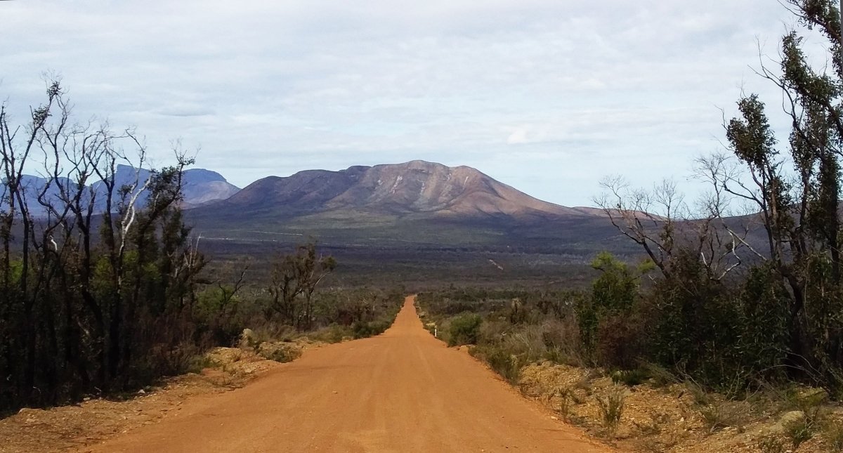
We visited the Park in September 2020 and were keen to see its regeneration following the bushfires. Sparked by lightning strikes, the fires between Boxing Day 2019 and New Year’s Day 2020 destroyed over 40,000 hectares — more than a third of its area.
Contractors and staff from WA’s Parks and Wildlife Service at the Department of Biodiversity, Conservation and Attractions (DBCA) spent months working to repair walking trails and infrastructure so they could be reopened.
SETTING UP SHOP
There are caravan parks in nearby towns, but the best way to enjoy the Park is by staying at one of the two caravan parks in the Ranges. The Stirling Range Retreat is close to the base of Bluff Knoll, the tallest peak, and it offers a bus service to various location as well as wildflower and bird watching tours.
We chose to stay a little further away at the Mt Trio Bush Camp and Caravan Park. Located in a peaceful bush setting on farmland with views of the mountains, it was an ideal spot for us to explore the Ranges.
There are shady powered and unpowered sites, and we picked our own spot. It wasn’t long before we had our caravan set up, with our chairs out in time for lunch. There is a well-equipped rustic camp kitchen and the Bluff Knoll Ski Club HQ built from timber salvaged from the closed Kundip mine site south of Ravensthorpe.
IMMERSIVE HISTORY
The Stirling Ranges stretches 65km from east to west, formed over millions of years by weathering and erosion, and towering dramatically above the surrounding lowlands and farmlands. Known as Koi Kyenunu-ruff by the Mineng and Goreng people, meaning ‘mist moving around the mountains’, it was respected and feared as a sacred and dangerous place. However the lowlands surrounding the peaks were an important food source.
Explorer John Septimus Roe renamed the Stirling Ranges in 1835 after Captain James Stirling, the first Governor of Western Australia.
Bushwalking is a great way to discover the scenic beauty of the Park — but be sure to consider your own fitness and capabilities. Many of the climbs take several hours, are challenging and require a high level of fitness, agility, and experience. However it is still possible to enjoy the Ranges by exploring its scenic drives and stopping at the lookouts for impressive views.
As I was recovering from a broken ankle and having climbed several peaks in the Park in our younger years, we decided to enjoy short walks and the scenic landscapes this time round.
Not far from the camp is access to Mount Trio, known as Warrungup by the Indigenous people, meaning ‘three become’. Mt Trio has three peaks, the highest being 856 metres. The first part of this 3.5km return climb is very steep, and you should allow three hours.
At Mt Trio we were shocked to see the destruction of the bushfires up close, with the blackened earth dotted with leafless black sticks. It was difficult to comprehend the complete devastation.
My husband chose to walk part way up Mt Trio while I walked around the lower slopes with my camera. Upon closer inspection I was amazed to see the number of red beak orchids sticking up through the blackened ground and ash. Red beaks love burnt earth and often grow in colonies where there has been a bushfire, and some can lay dormant for years waiting for a bushfire to assist their growth.
Also significant were the silvery-leaved Kingia australis, also called bullanock. From the Dasypogonaceae family, they look very similar to Xanthorrhoea grass trees, however are not closely related. I was fascinated by the multitude of globular flower clusters poking from the top of the thick blackened bases. Growing very slowly, these plants can live for centuries. We were told that within 10 days of the bushfire the kingias had started sprouting.
HEADING DEEPER
From Mount Trio we continued to Bluff Knoll. At 1059m above sea level, Bluff Knoll is the highest peak in the South West region and is known as Bular Mial meaning 'many eyes' by local Indigenous people, who believe the clouds curling around Bluff Knoll are the visible form of Noatch, a lonely spirit who cannot hold shape for long.
Bluff Knoll has the most popular and developed trail in the Park, affording outstanding 360-degree views from the summit. I recommend starting early so you can complete this 6.8km return climb in daylight. Allow 3–4 hours.
Winter snowfalls sometimes occur on the peaks, but you need to arrive early before it melts. It is the only place in Western Australia to receive snow regularly.
At the Bluff Knoll carpark, there is a wheelchair-friendly boardwalk, lookout, picnic tables, and seats, allowing everyone to enjoy the mountainscapes. An information shelter introduces you to the Park.
Contractors spent four months working here to repair the extensive bushfire damage to the Bluff Knoll trail. The height of the new trail steps have been decreased, making the trail easier to climb.
For those interested in wild orchids, you can enjoy an easy one-and-a-half hour morning guided wildflower orchid walk during September and October from the Mt Trio campground. Led by experienced orchid hunter Jarrad, we saw 26 varieties during our walk, including Josephs Spider Orchid caladenica polychroma and the Zebra Orchid caladenia cairnsiana. Many of these orchids are tiny or well-hidden, so the walk taught us what to look for.
Over 50 species have been discovered on their walks around the camp over the last few years and Jarrad said there would be different orchids flowering in October. There are identification photos in the camp kitchen.
In the afternoon, we drove to Mt Toolbrunup. At a height of 1052m, this is the second-highest peak in the Park, and one of the more challenging climbs. You must be prepared to scramble up some steep rocky sections. Allow 3–4 hours for the 4km return trip.
Jarrad told us the January bushfire was so hot that Mt Toolbrunup, which you can see from the camp, went up like a volcano and was burnt entirely in 45 minutes.
During our walk along the rocky trail it was heartening to see green shoots and evidence of the bush regenerating as well as numerous wild orchids, including little pink fans — a species new to us.
Unfortunately, environmental experts say the biodiversity of the Park may never be the same. At least 14 flora species have been critically endangered. If bushfires are too frequent, plants do not have enough time to produce viable seed, reducing the reproductive capacity of the plant and in turn, changing the whole food chain.
ON THE ROAD
For those not wanting or able to climb, the 115km scenic circular drive through the Park is a good way to experience the rugged peaks, mountains, and stunning views of the Ranges.
We headed west along Salt River Road, before turning south along Red Gum Pass Road and then east along Stirling Range Drive. By doing this, the sun was behind us in the afternoon as we drove through the mountains.
There are various picnic areas, lookouts and mountain trails to explore along the way. We added 10 more orchid varieties to our list and many wildflowers.
The Park is rich in banksias, eucalypts, orchids, verticordias feather flowers, and 10 species of darwinia mountain bells in a mosaic of thickets, woodland, mallee heaths, and wetland habitats.
Around 150 bird species have been recorded including western rosellas, and the rare crested shrike-tit, and Carnaby’s black cockatoo, so bird watchers will certainly enjoy this drive.
As we turned east along Stirling Range Drive, it was obvious the gravel road had formed a partial firebreak, being green to the north and burnt black to the south. It was along here that we saw the Scarlet Banksia, known as Waddib by the Noongar people. Growing around 1–8m tall and displaying superb vibrant red flowers from June to January, it only grows in a small area of our state. We had only seen them once before in the wild, in the Fitzgerald River National Park on the south coast. It is a prolific nectar producer, and the seeds are eaten by birds such as cockatoos.
We stopped at the White Gum Flats picnic area for lunch, and about half an hour later at Central Lookout, where there is a 30-minute return steepish walk trail to the top of a small knoll, from which you can enjoy impressive views of the ranges.
After returning to camp we walked down the five-chain paddock to the National Park and along the edge of the firebreak, where the bushfire once came right to the edge of the farm.
Common mammals which may be seen are the western grey kangaroo and western brush wallaby. Numbats and dibblers have been reintroduced to the Park as part of the Perth Zoo and Western Shield’s work to recover native animal populations through control of foxes and feral cats.
If you have time and want to explore further, the Porongurup National Park is only 45km away. It has various mountain walk trails and, for the agile, there are magnificent views to be had from the Granite Skywalk at Castle Rock. Mount Barker and the Great Southern region is a premier wine-growing region with numerous wineries to visit.
Late in the afternoon, we sat outside our caravan absorbing the tranquillity as the sun set over the paddocks. Our four-day break was over too soon, but despite the bushfire destruction, we had experienced much of the Park. We have promised ourselves a return trip and hope to see continued recovery from the bushfires of this precious region brimming with biodiversity.
FAST FACTS
Location: 400km south of Perth via Albany Highway, 80km north of Albany via Chester Pass Road, or 62km east of Mt Barker.
Best time to walk: August to October for wildflowers.
- Weather can change quickly, so always carry a jacket. Bushwalking is not recommended in hot and windy conditions due to bushfire risk.
- Read the information boards and be aware of the time taken for the climbs, as well as your abilities and fitness. Start early to allow time to do the climb and return in daylight.
- The walk trails are steep with sloping, slippery, and uneven surfaces. Wear boots or sturdy footwear, weatherproof clothing, and sun protection. Take plenty of food and drinking water.
- Stay on designated tracks and trails. Take extra care near rock edges.
- Camping and lighting cooking fires not permitted in the park. Please take all your rubbish out with you. Moingup Spring campsite is closed due to extensive fire damage.
- Daily wildflower/orchid walks September and October from Mt Trio Bush Camp and Caravan Park.
- Daily walking tours, August to October, led by Birdlife Australia volunteer guides, from Stirling Range Retreat.
- Park Visitor fees apply. Refer to: WA Department of Biodiversity, Conservation and Attractions. shop.dbca.wa.gov.au/collections/park-passes
MORE INFORMATION
- WA Department of Biodiversity, Conservation and Attractions: parks.dpaw.wa.gov.au/park/stirling-range
- Australian Government, National Heritage Places: environment.gov.au/heritage/places/national/stirling-range
- Trails WA: trailswa.com.au
- Mt Trio Bush Camp & Caravan Park: mttrio.com.au
- Stirling Range Retreat: stirlingrange.com.au
- Mt Barker Visitor Centre: mountbarkertourismwa.com.au
- Mt Barker Wines: mountbarkerwine.com.au
- Porongurup National Park: porongurup.asn.au


