A Winter Escape

It won’t be long before nights will be getting cooler and the first of the winter cold fronts will be sweeping across the country, with plenty more to come!
A great winter plan for those living in Western Australia, and of course wandering nomads from the Eastern states, is to head north and take in some of the beautiful places spread along the extensive Western Australian coastline.
HEADING NORTH
The newly opened Indian Ocean Drive from Lancelin is the first of many great experiences to be had. This sealed coastal drive is a much more scenic option than simply heading north on the inland Brand Highway towards Geraldton.
With splendid coastal views, there are numerous stops along the way, such as Wedge Island and Grey, but the first main spot to check out is the famous Pinnacles in Nambung National Park. The tall limestone spires and shapes seemingly frozen in time are a wonderful sight. Allow around two hours to look through the Visitor Centre and follow the driving trail through these fascinating formations.
The coastal run from here takes in delightful fishing villages including Cervantes (explore the ancient stromatolites), Jurien Bay (sea lion boat tours), Green Head and Leeman. All of these towns have facilities, including fuel, a place to get a cuppa or buy a snack, plus caravan park accommodation when it’s time to put your feet up.
To the North there are several free camping areas on the waterfront at Cliff Head, just before the Indian Ocean Drive joins the Brand Highway. Further on, the twin towns of Dongara and Port Denison have plenty to interest, including historic buildings along an enjoyable heritage trail and a great local bakery. Down by the water is a picturesque boat and fishing harbour, swimming beach, children’s playground and a caravan park right on the beachfront.
Next is the historic village of Greenough. Rich early history of the area oozes through with its beautiful old homes, churches and Hampton Arms Hotel.
The city of Geraldton just up the road is a rapidly growing area. With an active port servicing the mining and grain industries, a large commercial fishing fleet including a cray fishing operation, a new boating harbour/marina and plenty of services and facilities, Geraldton is a good spot to stop and replenish supplies before heading further north. While here don’t miss the Museum of Geraldton and the splendid HMAS Sydney Memorial to the 645 sailors who lost their lives during WWII.
The next main port of call heading north is the coastal town of Kalbarri. It is best to turn off Highway 1 at Northampton and swing towards the coast to take in the fishing village of Port Gregory, marvel at the fascinating pink salt lake and to have a look around the convict ruins at Lynton before heading to Kalbarri.
Another approach to the town, from the south, takes a look at the dramatic coastal gorges, including Eagle Rock, Natural Bridge, Pot Ally Gorge and Mushroom Rock — all quite spectacular and best seen in the afternoon light.
In Kalbarri itself, Rainbow Jungle (an award winning parrot breeding centre) is well worth a visit. You can also paddle up the Murchison River, go horse riding, take a scenic flight at sunset to see the coastal cliffs, fishing charters and, not to be missed, have a seafood meal at Finlay’s (a rustic local restaurant).
In the National Park just out of town, walk and drive trails lead to the spectacular gorge country of the Murchison River. Don’t miss places like Nature’s Window, Z Bend and Hawks Head, and if you’re here in spring, the wildflowers in the area are quite amazing.
North from Kalbarri, near the Galena Bridge, there is a nice free 24 hour rest area right on the riverbank which is always a popular spot for travellers. There are toilets here but no other facilities.
KEEP GOING
Further northwards, Overlander Roadhouse marks the entry to the region of Shark Bay. With the coastal town of Denham as a base, this World Heritage listed area includes diverse attractions such as the Monkey Mia dolphins, dugongs, turtles and other aquatic life; ancient stromatolites; a pearl farm; local star gazing tours; Shell Beach; the beautiful Francois Peron National Park, with its red sand dune cliffs meeting the sea; and the lovely artesian water ‘hot tub’ at Peron Homestead.
Back on the North West Coastal highway, it’s another 200km north to Carnarvon, the main service centre for the Gascoyne Region. The area here is a large fruit and vegetable growing region with water supplied by the mighty Gascoyne River. An awesome sight when it is in flood, in dry periods it continues to flow underneath the riverbed.
Carnarvon, with tropical, tree-lined streets, is a busy commercial fishing port. Lying just north of the 26th parallel its warm winter climate is helping to make it an increasingly popular tourist destination.
While in Carnarvon check out the Heritage precinct, including the famous One Mile Jetty (1897) where you can take a ride in the quaint ‘Coffee Pot’ train to the end of this famous icon. Make sure you stock up on local fruits and veggies here before heading further north.
Around 20km out of Carnarvon, a turn-off leads to the Blowholes at Point Quobba. Here you can check out the spectacular blowholes, the tall coastal cliffs, try some balloon fishing, get a view of the huge Cape Cuvier salt export facility and, a little further north, see the beautiful waves that roll in at Red Bluff — a mecca for keen surfers from around the country. There are shire campsites and station stay accommodation along this coastline.
Further north lies the beautiful Ningaloo Reef which stretches some 260km along the coastline, with coral in many places seen just a few metres off the beach. There are wonderful diving and snorkelling areas, glass bottom boat tours, plenty of good fishing and within Cape Range National Park there are beachfront campsites, spectacular gorge country, a turtle centre, bushwalking options and a delightful cruise (run by National Parks) up Yardie Creek. Both Coral Bay and Exmouth are popular centres for travellers to stop off.
Between March and June here, there is the opportunity to swim with the huge whale sharks that inhabit these waters at that time of the year, or swim with giant manta rays year round.
The next coastal detour is the small town of Onslow. On the way into town you can’t help but notice hundreds of termite mounds, some standing up to two metres tall, on the undulating countryside. This quiet township has caravan park facilities, good fishing spots and the nearby ruins of the old Onslow townsite are worth a visit.
Continuing northwards, the Pilbara Region is next, with plenty of colourful rocky outcrops, spinifex covered hillsides, creek beds and large river systems, including Fortescue and Robe Rivers. In late winter colourful Sturt Desert Peas and Mulla Mullas can be seen along the way.
At Robe River there is a free riverside camping area with shade and pleasant water views that’s popular for overnight stays. A little further on there is another a popular camping and fishing spot at Forty Mile Beach overlooking the water — it’s usually busy here in winter.
AND GOING
The modern town of Karratha has a wide variety of services and accommodation options available. Nearby Dampier has an attractive palm-lined coastal foreshore and tours are available to look over the huge Dampier Salt operation, iron ore port facilities and, on the nearby Burrup Peninsula, Woodside natural gas operation has a Visitor Centre with tours available.
While you’re here don’t miss the beach at Hearson’s Cove. A popular swimming spot, it’s a good place to watch ‘staircase to the moon’ when a low tide coincides with the rising full moon. The Burrup is also the site of many ancient Aboriginal rock art engravings (petroglyphs).
Further up the highway in Roebourne, look for Aboriginal murals on town buildings, pavements, poles and rubbish bins. This is a historic centre with plenty of old buildings, and the old prison is now the rustic and charming home of the town’s tourist centre. A visit to the nearby old pearling town of Cossack (the northwest’s first port) and Point Samson (try the fish and chips from Moby’s Kitchen) is also recommended.
Whim Creek, once a thriving copper and gold mining township, has a beaut old pink pub — a real icon of the Pilbara. Don’t miss having a look around the bird aviary as you enjoy a drink in the beer garden.
Northwards the countryside becomes mostly flat, open cattle grazing country. The picturesque Yule River, 61km from Port Hedland, has a free 24 hour rest area with plenty of shade right beside the water.
THE FINAL LEG
The busy mining town of Port Hedland also offers interesting tours of their operations, another opportunity to see a ‘staircase to the moon’ at Cooke Point, plenty of services and several shopping centres — your last place to top up on supplies before heading onto Broome 613km away — and there is a new free rest area close to the town centre.
As the highway swings east and then north-east towards Broome, there is another free overnight campsite beside the DeGrey River (81km from Port Hedland) and onwards from there, for those keen on fishing, Pardoo Station and Cape Keraudren are popular getaways right on the coast.
The well-appointed Eighty Mile Beach Caravan Park, 10km off the highway and 245km from Port Hedland, is a popular spot for an overnight break or for a longer stay.
Further on, Port Smith and Barn Hill are both popular spots. Access to Barn Hill, a station stay experience, is by a sandy track but suitable to all vehicles and is one of our favourite places. There is a rustic caravan park with powered and unpowered sites, a beautiful beach, colourful scenic cliffs and beachfront outcrops, good fishing, a lovely swimming beach and a small shop with basic supplies, ice creams and pizza. There is even a lawn bowling rink and regular special happy hour get-togethers.
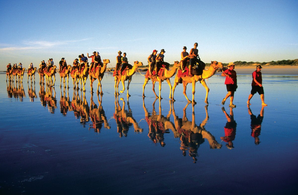
From here Broome, ‘the port of pearls’, is just 130km away and as you drive into this appealing multi-cultural town it is like entering another world. The beautiful blue waters of Roebuck Bay, camel rides on Cable Beach, the tropical laid-back feel of the place and the many tourist attractions available here will keep most visitors busy for days, weeks or even months before either heading back south or further into WA’s scenic Kimberley region.
INLAND ROUTE
Another option from Perth is to take the inland route to enjoy some quite different experiences. Stops along the way can include:
- New Norcia, where you can tour a monastery founded in 1846 and still run by the Benedictine Monks;
- Dalwallinu and Wubin, where you pass through an extensive grain producing region;
- Paynes Find and Yalgoo which mark the beginning of the Murchison Goldfields region;
- Mount Magnet where there is an area known as ‘The Granites’ and ‘Amphitheatre’;
- Cue and Meekatharra with historic ruins, old time architecture, Walga Rock with its old Aboriginal paintings, the ghost town of Big Bell, as well as huge modern open cut mines operating 24 hours a day;
- Newman, with an open cut mine tour available, a 4WD gorge, waterhole and Aboriginal rock art trail;
- Munjina East Gorge, one of the most scenic sections to be found along this entire route;
- And Indee Station, which provides a great station stay experience, with beautiful sites around their property, including some ancient Aboriginal rock engravings.
MORE INFO
- Travel distance from Perth to Broome: approximately 2,200km all fully sealed roads, suitable for all vehicles
- Best time to travel: May to September — usually hot and humid in summer wet season
- Fuel prices at most north-west centres and roadhouses are 20c to 30c dearer than city prices
- Staircase to the Moon dates and times are available at local visitor centres
- As you pass through townships along the way contact local visitor centres for details of nearby attractions
- Visit: www.australianorthwest.org.au or www.pilbara.com or www.australiascoralcoast.com


