
Wilsons Promontory National Park, VIC
Wilsons Promontory is a place of extremes. It’s barely 160km east of Melbourne, yet contains the largest coastal wilderness area in Victoria – over 500sq km. Being the most southerly tip of the Australian mainland, surrounded on three sides by the Bass Strait, the peninsula can be blissfully balmy under shining azure skies one day, then lashed by squalls and howling gales the next. Its human landscape was forged in the mystic Dreamtime of the Gunai-Kurnai people and shaped by 200 years of European exploitation.
Once plundered for its wildlife and natural resources, it is now the state’s oldest existing national park, protecting a vast array of plant and animal species. Ironically, the national park’s peaceful isolation proved an ideal training ground for commandos who practiced their deadly and clandestine skills here during World War 2.
Yet despite these stark contrasts, or perhaps because of them, The Prom (as it’s affectionately known) attracts around half a million tourists annually. It is so popular that day-visitor vehicle numbers in the national park are limited to 800, and the 500-odd sites at the Tidal River Campground are allocated for the five-week Christmas holiday period by ballot. Fortunately, we didn’t have to compete to that extent when we stayed for a few days in late summer, but the campground was well patronised just the same, and the weather just as fickle.
In the national park’s early years, access to the Prom was difficult: it could be approached by boat, with the risk of being swamped by waves, on horseback or by car, along a 10km stretch of beach, over treacherous sand drifts and along “an unsurfaced road with many scars causing considerable discomfort to the occupants”. Although the journey to the park is not the adventure it once was, it’s still a very pleasant scenic drive.
From the South Gippsland Highway, we followed sealed minor roads through picturesque rural countryside to the Yanakie general store for a few provisions and fuel (the latter being unavailable within the park). The main road continued through the park entrance and followed a winding route along the hilly western side of the Promontory. By the time we reached Tidal River, 30km inside the park, we had a pretty good introduction to the park’s varied land and seascapes: a ruggedly beautiful coastline of plunging cliffs and rocky headlands interspersed with tranquil coves and white-sand beaches and a mountainous hinterland cleft by fern gullies and domed with bulbous granite outcrops.
TIDAL RIVER
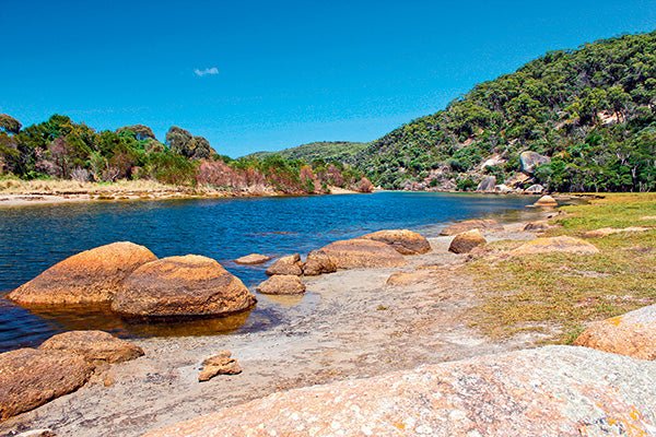
The jewel in the crown of all this natural splendour and a major attraction for visitors is the Tidal River, which flows in a tea-coloured ribbon from its headwaters in the Wilson Range into Norman Bay on the western side of the peninsula. It is unique for having one of the few undisturbed catchments in Victoria and contains about half of the 40 known species of native freshwater fish that occur in the state. As its name suggests, Tidal River swells with the tide and, if a high tide coincides with heavy rain in the mountains, the river can flood the wetlands in its lower estuary.
The river lends its name to the settlement nestled in the sand dunes behind Norman Bay that is the main focus of tourist activity and accommodation in the national park. Tidal River Campground has 484 camping and caravan sites (including 20 powered sites) near the beach and river. Other accommodation includes cabins, huts, group lodges and award-winning Wilderness Retreats, which provide a ‘close to nature’ experience with queen-size bedding and a well-equipped camp kitchen. When fully occupied, the settlement swells to over 2000 people.
Although we found the camping fees a bit steep – among the dearest anywhere in Australia at $53/night for a powered site – we certainly got our money’s worth, with excellent facilities: modern amenity blocks with flush toilets and hot showers, laundry facilities, dishwashing stations and picnic areas equipped with free gas barbecues. There’s also an education centre, post office, take-away café, medical centre and open-air cinema, where summer campers may queue for over an hour for front row tickets.
The Tidal River General Store stocks milk, bread, ice, gas refills and souvenirs, plus a limited range of supermarket and camping equipment.
Elsewhere in the park there are 10 remote walk-in camps with minimal or no facilities, and Stockyard Camp, a small grassy campground with limited facilities set in native bushland near the park’s entrance, providing unpowered camping for tents, caravans and motorhomes. There’s no beach access from Stockyard Camp, but a signposted walking trail leads to the northern flank of Big Drift, an extensive series of inland sand dunes with stunning views across Waratah Bay to Cape Liptrap.
Under a clear blue sky, we set up on a grassy site at Tidal River, with views between the many vans and motorhomes to imposing granite peaks in the nearby ranges. As the sun dipped toward the western horizon, we made our way to Norman Beach for a grandstand view of Mt Oberon, its burnished reflection shimmering in a broad swathe of sand unveiled by an ebbing tide. As the sunset faded, we strolled the length of the beach from Pillar Point to Norman Point, invigorated by the cool water around our ankles and the tang of a gentle sea breeze.
BUSHWALKING
Among the many opportunities for outdoor recreation in the Prom – including surfing, snorkelling, fishing and boating – the most popular and easily the best way to experience the park’s splendid natural environment is bushwalking. This 50,000ha reserve is threaded with a labyrinth of some of the best walking tracks in the state, ranging from short strolls and moderate 2-3 hour walks, overnight hikes and challenging multi-day treks.
Many of the trailheads begin at or near Tidal River and explore the headlands and beaches along the adjacent coast or reach up to the heights of Mt Bishop and Mt Oberon.
One morning we set off along the Loo-Errn Track, a 1km boardwalk over fragile wetlands, to the south bank of the Tidal River. On a broad sand bar nearby, a group of enthusiastic campers were contesting a game of beach cricket, while others were enjoying the placid river in kayaks. Crossing a footbridge, with platforms provided for fishing, the trail climbed to Tidal Overlook, the highest point between Norman and Leonard bays, with panoramic views across the riverine wetlands to Mt Oberon (585m). Along the way was a rest stop, dubbed the Quiet Place, dedicated to rangers worldwide who have lost their lives in the line of duty. A short detour led to an outcrop of granite boulders with a splendid view of the rocky summit of Mt Bishop (319m) rising from dense stringy-bark forest. Continuing on the circuit track through banksia heath and wildflowers, we followed the elevated ridge to Pillar Point, with breathtaking views over Norman Bay to the south and Leonard Bay to the north.
From the headland, a 6km trail connects Leonard Bay, Picnic Bay and Whiskey Bay and their magnificent beaches. The nearest is the iconic Squeaky Beach (also known as the ‘singing sands’), so called because of the sound made by walking on the brilliant white, ultra-fine sand. We opted to walk the loop back to Tidal River for our car and drove to the beach for a surf and a picnic lunch. An added attraction was the cluster of unusual rock formations and intertidal pools at the end of the beach in the lee of the northern headland.
WEATHER WARNING
Next day, the weather was cool and overcast, the prelude to a ‘severe weather event’ forecast to arrive later in the day. In the morning though, conditions were perfect for our planned excursion to Mount Bishop, which began with a short drive to a carpark at the head of the Lilly Pilly Gully Track. From here, the trail climbed across the southern foothills of the mountain through stringy-bark forest, in which blackened tree trunks and newly regenerated undergrowth bespoke the disastrous bushfire in 2009 that began with a lightning strike near Sealer’s Cove and burned over 25,000ha of the national park. After a couple of kilometres, we diverted on the track that climbed steeply to the rocky summit of Mt Bishop, where our efforts were rewarded by spectacular views that embraced the park’s southern ranges and scalloped coastline. Returning to the Lilly Pilly Gully track, we continued the circuit through towering eucalypts, groves of lush rainforest, open woodland blanketed with head-high ferns and heathland that morphed into the river’s wetlands below Mt Oberon.
By now the weather had deteriorated and we hurried back to camp to batten down the hatches by stowing away moveable items and lashing down the annex with extra guy ropes. As the afternoon wore on, the wind veered to the southeast and escalated to gale force – an expression that rolls blithely off the tongue but has to be experienced to be believed – ripping dark clouds over the granite ridges and hosing showers across the campground. The tempest continued through the night; rain drummed on the roof as our small van was buffeted and rocked by gusts that snapped the annex taut with a report like a maxi yacht’s spinnaker.
Next morning, watery sunshine filtered through ragged clouds to lure us out onto the headland of Norman Point. Close to Norman Beach, conditions on the track were deceptively calm, shrouded by Tea Tree and sheltered by the towering bulk of Mt Oberon. But as we progressed further west, out of the mountain’s lee, we were hit by a ferocious wind that swirled around the rocky shoreline, whipping wraiths of spray away into Bass Strait.
At the tip of the Point, the lookout revealed a tableau of wind-swept torment – no waves as such, nor swells of any degree, just millions of white horses as far as the eye could see in every direction.
Wilsons Promontory is a wild and majestic landscape of sun-drenched beaches, lush rainforests and ancient granite outcrops from headlands to hinterland peaks. It is nature at its spectacular and panoramic best, the perfect place to get out, onshore and offshore, or to chill out and relax. The Prom is a park for all people in all seasons.
FAST FACTS
Getting there
- Wilsons Promontory is about three hours’ drive south-east of Melbourne via the South Gippsland Hwy. Tidal River is 30km from the park entrance, which is just south of Yanakie.
- All roads to and around the national park are sealed and suitable for 2WDs towing caravans or camper trailers.
Activities
- Bushwalking and overnight hikes
- Camping
- Kayaking
- Swimming and surfing
- Snorkelling and scuba diving
- Photography
- Bird-watching and nature appreciation
More info
- Yanakie, Fish Creek and Foster are the nearest towns for fuel and supplies.
- No fuel is available in the national park but the general store at Tidal River stocks a limited range of supermarket items and camping gear.
- Bookings are essential for holiday periods and a ballot system operates for peak periods; permits are required for overnight hikes.
The full feature appeared in Caravan World #558 December 2016. Subscribe today for the latest caravan reviews and news every month!


