
The Victoria Highway
Between Katherine, NT, and Kununurra, WA, the mighty Victoria River cuts a meandering path across savannah plains that rise to sandstone escarpments peppered with ancient boab trees.
With little more than a couple of roadhouses servicing this remote section of Highway One, Vic country is one of the Top End’s most untamed regions, luring anglers chasing barramundi to the banks of croc-filled waterways. In Gregory National Park, offroad travellers can test their mettle on some of the roughest roads around to reach historic pioneering landmarks and swimming holes nestled in lonely limestone gorges.
Conventional rigs can discover the Flora River’s limestone tufa waterfalls, hike to Aboriginal art sites located right on the highway, access great fishing spots and stoke up a campfire at wonderful bush camps where rare wildlife abounds. For adventurous across-the-top travellers, the journey through Vic country is bristling with potential. Stock up on supplies, allow plenty of time and get set to explore.
FLORA RIVER NATURE PARK
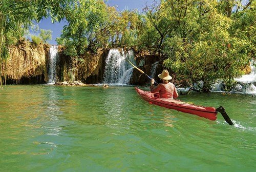
At Kathleen Falls, about 130km west of Katherine, limestone tufa dams snag the Flora River, dropping the water swiftly into swirling, jade-coloured spas. Feeding on the cool mist, pandanus and paperbark trees stretch their limbs out over the stream that ebbs away past crocodiles hunting barramundi in impossibly translucent pools.
Attracting anglers and paddlers and providing generously for campers, Flora River NP protects a 25km-long stretch of the spring-fed Flora River, along with its surrounding floodplain and savannah woodland. With walking trails, a boat ramp for canoes and travel-sized tinnies, and the opportunity to spot crocs, birdlife and catch barramundi, this destination could occupy adventurers for days.
Estuarine crocodiles make their way up the mighty Daly River to feed on freshwater fish in the Flora too. While we didn’t spot a saltie the last time we paddled the Flora River, moving swiftly past an enormous saltie trap gave us quite a scare.
Swimming is obviously off-limits, but even boaties need to take care. Keep your arms and legs inside your boat, don’t lure crocs by cleaning fish at the water’s edge and be especially aware at night and during the September to April breeding season when crocodiles are more active.
To reach the park, turn off the Victoria Highway 86km west of Katherine and continue for 46km along an unsealed access road (allow 45 minutes from the turn-off). This road is generally suitable for 2WD vehicles with high clearance in the dry season from April to October.
VICTORIA RIVER
Heading west, the highway continues across the mighty Victoria River to a civilisation of sorts at the river roadhouse, about 194km from Katherine.
Here, you can plug into power at the riverside campground, enjoy home-cooked meals, and spend an afternoon fishing and birdwatching. Over the winter months, national park staff host free guided river walks, setting out from the boat ramp located on the south-west side of the river crossing. Popular river cruises that provide a unique view of one of the north’s wildest rivers and its inhabitants run from April to September.
GREGORY RIVER NATIONAL PARK
Divided into two sections, this remote and rugged national park is the state’s second largest, covering 13,000sq/km of sandstone escarpments, gorges and eucalypt woodlands. Rich in Aboriginal, pastoral and European exploration heritage, the park also protects an important habitat for the rare gouldian finch and the purple-crowned fairy wren. Navigable in winter’s dry season, a huge network of 4WD tracks lead to camps at the historic Bullita Homestead, Limestone Gorge with its swimming hole and, easiest to reach, Jasper Gorge.
To reach this scenic chasm carved into the Stokes Range, take the signposted turn off the Victoria Highway, 28km east of Timber Creek and continue south. There’s little more here than awesome, expansive views and a nearby bush camp on the edge of a permanent waterhole that provides no facilities, but it’s a pretty overnight stop for travellers venturing east on the Buchanan Highway to Top Springs and beyond.
TIMBER CREEK
Wet season deluges that swell the Victoria River frequently sever the highway, forcing annual bouts of isolation on the resilient residents of tiny Timber Creek, a popular traveller’s rest-stop. The first to resupply here was explorer Augustus Charles Gregory, leader of the 1855 Northern Australia Expedition whose crew cut planks from tall paperbarks along Timber Creek to repair their damaged supply ship, the Tom Tough.
For stellar sunset views, drive to the top of the escarpment that rises above Timber Creek where a memorial honours the Nackeroos (North Australian Observation Unit 2/1st NAOU), bush commandoes who patrolled the far north’s coastline on horseback from 1942 to 1945. Made up of around 600 men including 59 indigenous Australians, the Nackeroos endured tough
conditions and an almost daily battle to survive, relying on their indigenous guides who taught them invaluable bush skills. Today, sun-wearied travellers can settle into comfier digs at Timber Creek’s Circle F Caravan Park (www.timbercreekhotel.com.au), where campers congregate with cold cans at the swimming pool and gather at dusk on Timber Creek to feed freshwater crocodiles.
KEEP RIVER NATIONAL PARK
This remote border park on the Territory’s western edge protects a landscape of crumbling sandstone escarpments and banded rock outcrops etched with petroglyphs and ancient ochre art. Bearing a resemblance to the famous Bungle Bungle Range across the Western Australian border, Keep River’s eroded stone beehives dominate the woodland forest and swampy grasslands that harbour rare gouldian finches.
The Jinumum walk (3km/1.5hrs) follows the Keep River to overhangs protecting orche art and grinding rocks pitted with smooth hollows can be spotted below.
Located 3km east of the NT/WA border and accessible to conventional vehicles, Keep River NP closes each wet season, making winter an ideal time to enjoy the cooler daytime temperatures and cosy evening campfires.
LAKE ARGYLE
The last detour before Kununurra, Lake Argyle covers a mind-boggling 1000sq/km, making this the largest man-made lake in the southern hemisphere.
Picturesquely set against the Carr-Boyd Ranges, this vast inland sea of bays, islands, waterfalls and creeks feeds a hydroelectric plant and the produce grown throughout the Ord Irrigation Area.
It’s impossible to get a sense of the lake’s enormity until you launch a boat, join a cruise or take a scenic flight over the lake. Those lakeside lookouts just don’t reveal the big picture! Beyond Lake Argyle, it’s just a short drive to Kununurra to resupply and rest up on the banks of Lake Kununurra and the Ord River before the next big adventure into the Kimberley.
Fast Facts
Getting there
- From Katherine, NT, the Victoria Highway stretches for 514km to Kununurra across the WA border.
Activities
- 4WDing
- Bushwalking
- Visit Aboriginal art sites: Flora River NP and Keep River NP
- Paddle down the Flora River
- Boating, barra fishing: Flora River
- Croc-spotting, birdwatching
- Victoria River cruise
- Visit Timber Creek Police Museum
- Fly over Lake Argyle
More information
- Katherine Visitors Centre: Stuart Highway, Katherine, 1800 653 142, www.visitkatherine.com.au
- Kununurra Visitor Centre: 75 Coolibah, Drive, Kununurra, (08) 9168 1177, www.kununurratourism.com.au
- Katherine Parks and Wildlife Commission: 32 Giles Street, Katherine, (08) 8973 8888,
- www.parksandwildlife.nt.gov.au
- Timber Creek office: (08) 8975 0888.
- Keep River National Park ranger: (08) 9167 8827.


