
MURRAY-SUNSET NATIONAL PARK, VIC
For those living in the south-east of this great country, and particularly for people who live in Victoria, the outback can seem like a distant dream, a long way off in the centre of the continent. But, it turns out, you don’t need to travel for days to get that feeling of isolation or to see endless stretches of red dirt and mallee scrub; you can find all this, and more, tucked away in the far north-west corner of Victoria in the Murray-Sunset National Park.
Murray-Sunset NP comprises 677,000ha of mallee bushland, and can be seen as encompassing three different sections. The far north-west section takes in Lindsay Island, right on the Murray River. The southern section is around the Pink Lakes area, which is suitable for all vans and 2WD vehicles. The roads in this area are unsealed but maintained, and there are basic facilities.
In the centre and north (the bulk of the park), are bush camping sites, unsealed roads (varying from good condition to pretty average tracks) and plenty of isolation. This part of the park has some challenging sections of track – there are some soft, sandy strips, quite a few corrugations and, in the low-lying areas, it can get boggy in the wet. For this central section, you’ll want a pretty tough offroad van or, alternatively, leave the van at the Pink Lakes and head off solo in the 4WD.
The distances are not daunting but travel can be slow – a rough guide is about 100km from east to west and also from north to south – and the majority of places to see are in the eastern quarter. Get your hands on a decent map before you go and you should get around without too much difficulty.
While overall the driving challenges are not too intimidating, if the weather gets ugly I’d head for the tar, or the relative comfort of the Pink Lakes. Remember that the park is quite isolated so make sure you’re well-stocked, particularly with water, and have some recovery gear and the appropriate communication equipment. Before you hit the park, stock up on food, water and fuel in one of the nearby towns, such as Mildura, Ouyen or Loxton. Of course, a puncture repair kit should be considered essential as small pieces of debris (such as mallee roots) adorn the tracks and can be lethal for tyres.
All camping must be in designated areas. And how good is this – no permits, bookings or fees, and campfires are permitted in the fire pits provided. There are a few camping areas throughout the park and they offer basic facilities including toilets, fireplaces, picnic tables, and some limited water. They are usually shady, flat and suitable for vans. There is also some bunkhouse-style accommodation in the Shearers’ Quarters in the north-west of the park.
Coming from Adelaide, the Shearers’ Quarters is ideal and we camped there on the first night. It’s a top spot, with high, shady trees and flat, open, van-friendly spaces, fire pits and a (pretty basic) long-drop. The Shearers’ Quarters themselves are worth a visit – grazing began here in the mid-1800s and the pastoral heritage is a feature of the park.
PASTORALIST’S PAST
There are two main west-east tracks – Pheeneys and the Sunset Track. We took Pheeneys this time. A rain front had passed through about a week earlier, so a few interesting boggy patches were added to the usual stretches of good, flat track, interspersed with some corrugations and rocky sections. No soft sand through here, though.
After 125km of dawdling along we stopped for lunch at the Cattleyards on the Grub Track. These are a classic post and rail structure, now totally dilapidated. But I love these little bits of nostalgia and this one confirms the ingenuity and seriously hard toil the pastoralists injected into the country.
We continued east to the relative civilisation of the Pink Lakes. The Pioneer Drive is billiard-table-flat and the main campground at Lake Crosby is neatly set out in defined sites, well-separated so neighbours are kept at a comfortable distance. This was deemed a good spot for our second camp.
The red algae in the lakes creates a beautiful pink tinge and makes for some great photo opportunities. There are a few short walking trails and Pioneer Drive is okay for cycling if you have bikes on hand. If you’re not feeling energetic, then a cold drink overlooking the lake on a warm day might be ample exercise – it was for us.
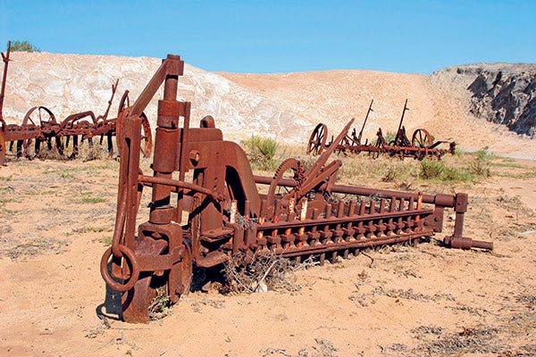
Out next day was spent roaming the tracks in the eastern quarter. Most are comfortable driving but the Mt Crozier Track up to Mopoke Hut has some seriously soft sand sections which, even with tyre pressures lowered, was a grind. But there’s plenty to see. The region was extensively mined for gypsum over the years and there’s some old machinery and equipment around the two tracks running in from the east: the Nowingi Line and the track out from Hatta. The plan was to open up the area with a rail line between Nowingi and the South Australian border in the late 1920s, but it was abandoned after only 24 miles of track was laid.
There are two comfortable campsites in this part of the park. Rocket Lake has shade, spacious sites, and toilet facilities. Brian Sheedy, who wrote a book entitled Discovering Mallee Country, reckons the lake got its name from the practice of setting off a flare from the camp to advise the railway workers that it was time for a smoko! Sounds reasonable, I guess. The campground at Mopoke Hut is bigger, with very usable space for a dozen vans. The hut itself is another remainder from the pastoral activities. We set up camp for the night – not a soul in sight, warm, no wind, early moon, and a steak on the hotplate. Nope, it doesn’t get any better than that.
ON TRACK
On our third day, we headed south-west over the Nowingi Line and Underbool tracks to pick up the eastern end of the Sunset Track. We only had a few days for this trip, so needed to start edging back westward. Most of the 45km on Sunset was very comfortable driving – with the motor just ticking over at about 40-50km/h, windows down, sun beaming in and keeping us warm, kangaroos scattering and birds playing.
There’s a variety of bird species in the park and while we were there, we bumped into a couple of nice researchers from La Trobe University, conducting bird research. Theirs is a longitudinal study counting various species by sector. They come out a few times each year for a week at a time and camp out. Good work, if you can get it!
The eastern portion of the Sunset Track has a few longer dunes and the sand can be a little soft. You’ll need to keep the revs up and maybe lower your tyres a little more. But, overall, it’s a good run. The road exits the park briefly and you follow the formed roads north and then back into the park where you can stop to check out the Rock Holes. Given the rich Indigenous history of the area, I imagine this source of water was an integral part of their semi-nomadic lifestyle.
The South Bore Track tackles a few firm sand dunes, rocks and mud holes, taking us back to the Shearers’ Quarters. This was our last night out, and we’d come full circle. The weather behaved and the campfire chat turned to our next trip…
Overall, Murray-Sunset National Park is a real gem. We did about 450km over a variety of tracks, experienced a range of vegetation and got a glimpse into our past. The tracks are well-signed, there’s good interpretative signage, and the facilities are adequate. While there are towns nearby, the body of the park is still quite remote so good preparation is essential. If towing your van in these conditions doesn’t sound like a good option, set yourself up at the Pink Lakes or the Shearers’ Quarters and take some day trips. It’s a great experience.
Getting there
Murray-Sunset National Park is in the north-west corner of Victoria, about 80km south of Mildura.
There are entry points on all sides of the park but the most commonly used for vans is off the Mallee Highway, west of Ouyen. You can also enter off the Calder Highway or east of Loxton through Taplin Gate.
Activities
This is a do-it-yourself experience, so you’ll need to make your own fun – enjoy the rich mallee scrub, go bushwalking, do some birdwatching, and check out some of the pastoral relics.
More info
You’ll need the national parks map and brochure. Phone Parks Victoria on 13 19 63.


