
High Road Driving
Extending 310km between Wangaratta in Victoria’s north-east to Bairnsdale near the Gippsland Lakes, the Great Alpine Road takes in some of Australia’s loveliest panoramas, from rolling vineyards, lush pasturelands and dense forests to some of the country’s grandest alpine vistas.
Meandering through Myrtleford, Bright, Harrietville, Mount Hotham, Dinner Plain, Omeo, and on to Bairnsdale, the drive has numerous side trips to gems such as Milawa, King Valley with its fine wines and prosecco, the charming streets of towns like Beechworth, and rugged beauty of mountain retreats such as Mount Buffalo, Mount Beauty, and Falls Creek.
-------------------------------
WANGARATTA TO BRIGHT, 83KM
The regional city of Wangaratta, 250km north-east of Melbourne and 626km south-west of Sydney, is the starting point of the Great Alpine Road, or the B500. Although the route is rural highway standard, it gets very windy through the mountainous regions it passes through.
Sections of the road were formerly known as the Ovens Highway between Bright and Wangaratta, and Omeo Highway between Lucknow and Omeo. The name Great Alpine Road came into use in 1998 when the final section between Mount Hotham and Dinner Plain was sealed.
Summer, autumn, and spring are ideal seasons to drive the Great Alpine Road with a caravan, as during the snow season, the section between Harrietville and Omeo is not suitable for towing caravans.
From Wangaratta, the B500 passes flat or gently undulating pasturelands studded with majestic redgums. A detour into Milawa, 16km south-east of Wangaratta, which features many of the gourmet offerings that abound in this corner of Victoria.
The Milawa Gourmet Region is centred around the townships of Oxley, Milawa, Tarrawingee, Markwood and Whorouly. In the historic town of Milawa, the Milawa Cheese Company has been producing fine cheeses since 1988. Then you can indulge in lunch at Brown Brothers Epicurean Centre or, further afield, relax on the terraces of Sam Miranda King Valley winery with a tasting plate piled with regional bounty, from locally made charcuterie to cheese and olives.
In downtown Milawa is the Old Emu Inn. Today the building is home to Milawa Providore, a cafe, providore and cellar door. Located in the old butchery, meanwhile, is Milawa Mustards, producing a range of 17 seeded mustards..
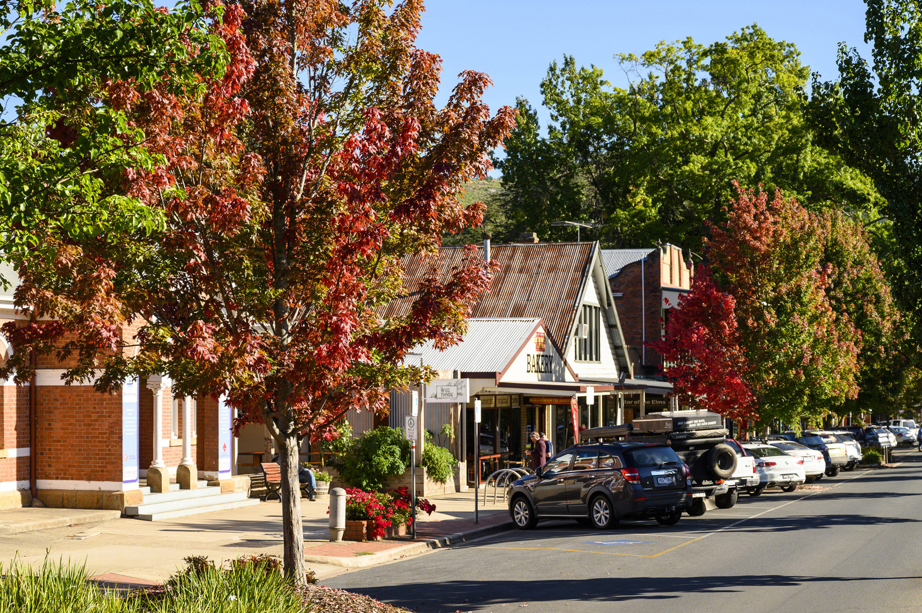
Another detour worth considering is Beechworth, 41km north-east of Milawa, where Ned Kelly, his mother Ellen, and Kelly gang members all spent time in jail.
One of Australia’s best preserved gold rush towns, with no less than 30 National Trust-listed buildings, Beechworth’s tree-lined streets boast an eclectic array of shops and some fine cafes and restaurants. The town is home to Beechworth Honey, the original Beechworth Bakery — and those famous Bee Sting cakes — and Billson’s Brewery, established in 1865.
From Beechworth it’s 28km south to the charming township of Myrtleford, situated amid rich alluvial flats with a backdrop of the bluey-green peaks of the Victorian Alps. There are several wineries in the area including traditional Italian Michelini Wines and Gapstead Wines, and this bountiful region also produces nuts, berries, olives and hops.
Situated on the Ovens River Valley below the Mt Buffalo Range, Myrtleford is where tobacco leaves were once harvested, and you can still see rustic kilns across the landscape surrounding this pretty town.
From Myrtleford, the Great Alpine Road winds 27km to the small now-retired sawmill town of Porepunkah and the C535 turnoff to Mount Buffalo National Park, one of the highlights of the Great Alpine Road.
A 36km drive twists and turns from Porepunkah to Mount Buffalo, so consider leaving the van at one of Porepunkah’s three caravan parks unless booked into Lake Catani Campground on the Mount Buffalo plateau.
Ladies Bath and Eurobin Falls is one of the first places you can stop on the way to Mount Buffalo. In the early 20th century travellers often stopped at this beautiful spot on their way to the Mount Buffalo Chalet. Men and women would separate, and Ladies Bath is where women would dip their toes into the refreshing waters of Crystal Brook.
Mount Buffalo is referred to as the ‘Island in the Sky’ because of its isolation on a plateau atop the mountain, which has resulted in an amazing biodiversity of plant life — Mount Buffalo is home to some 550 species of plants, including several found nowhere else on Earth. The lofty drive winds through peppermint forests, tall stands of alpine ash and snow gum woodlands to sub-alpine grasslands at higher altitudes. It’s a picture here in summer, when carpets of wildflowers including yellow billy buttons and royal bluebells bloom across the plateau.
Historic Mount Buffalo Chalet, built in 1908, has grand views of sheer cliffs, granite tors, and the valley below. While the building is currently closed for renovation (with plans to hopefully reopen in coming years), the chalet is surrounded by pleasant gardens dotted with picnic tables for visitors to enjoy.
Mount Buffalo has numerous hiking treks amid snow gum forests to lookouts with big views, as well as waterfalls, lakes, and plenty wildlife and birdlife — rosellas, cockatoos, parrots, yellow robins and honeyeaters are common, and shy lyrebirds are often seen amid the snow gums.
From Porepunkah it’s 8km to Bright, popular for its riot of red, orange and copper-coloured leaves during autumn, and as a stop-over during the winter months for skiers heading to Mount Hotham and Falls Creek.
Nestled in a valley alongside the Ovens River, Bright features a host of cafes, the popular Bright Brewery, and tasty gins at Reed and Co Craft Distillery.
The area around Bright boasts world-class mountain-biking trails, plenty of walks, including the Canyon Walk, a 5km riverside trail showcasing remnants of goldmining days, and the town’s Centenary Park on the banks of the Ovens River with its River Pool and popular Splash Pool.
BRIGHT TO OMEO, 108km
From Bright, the Great Alpine Road hugs the Ovens River as it cuts across farmland and rolling hills, passing through the hamlets of Smoko and Freeburgh on the scenic 22km drive to the old goldmining town of Harrietville.
Situated at the base of Mount Feathertop and Mount Hotham, this quaint town features a small commercial centre that includes a general store and two hotels, some attractive parks including Pioneer Park which features a museum and displays of the region’s history, and some fine Alpine walking trails.
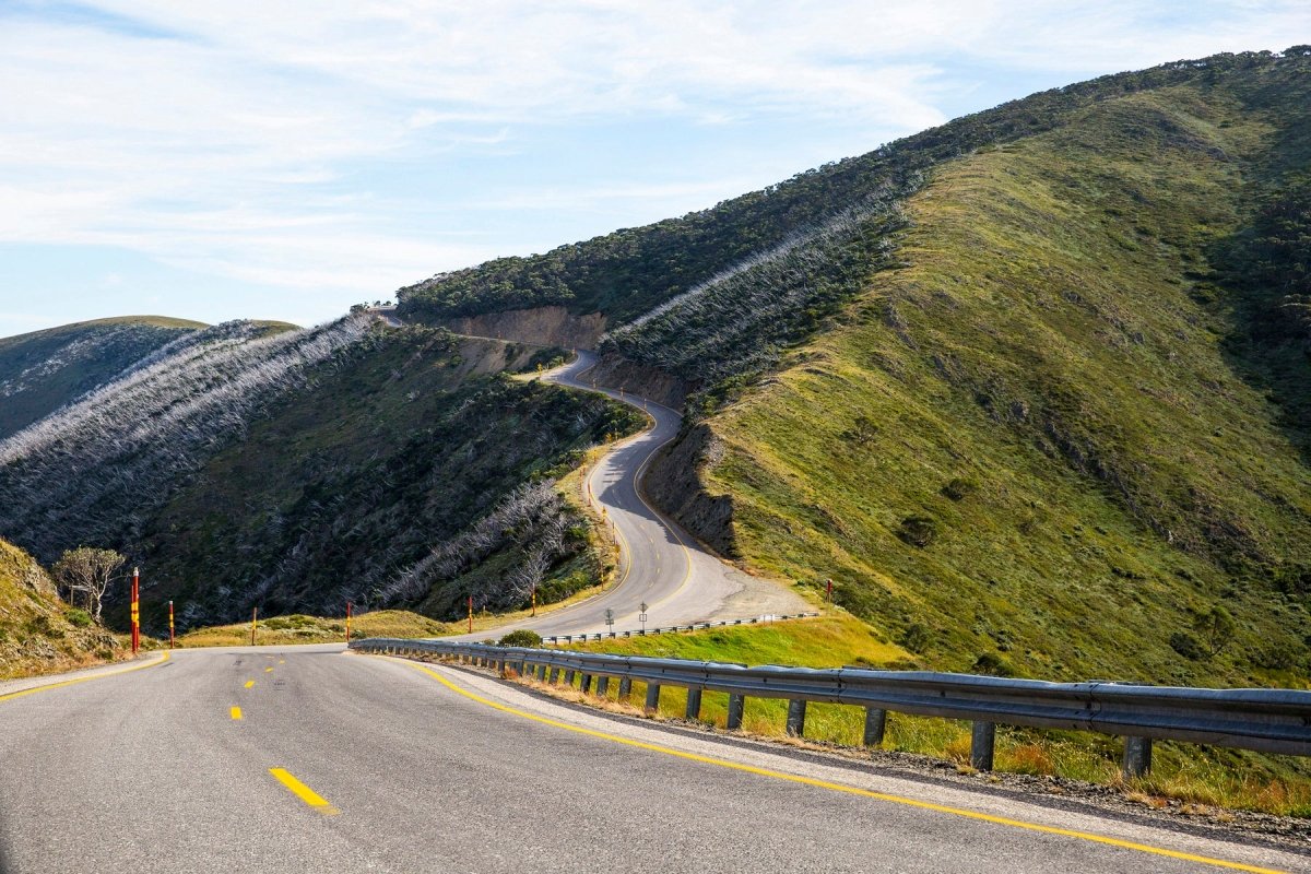
From here it’s 30km to Mount Hotham, Australia’s highest village. As the road snakes higher it hugs steep slopes through a forest of alpine ash — the tallest flowering trees in the world — then snow gum forest begins to appear.
The road is winding, and there are plenty of hair-pin bends along the way, so driving can be challenging with a van. There are several places to pull over for a break and take in one sweeping view after another unfurling on each bend of the road.
As the altitude rises and the temperature drops, even in summer, the vegetation thins and the road snakes its flint-grey way to the summit, lined by tall orange warning poles marking the edge of the drop-offs.
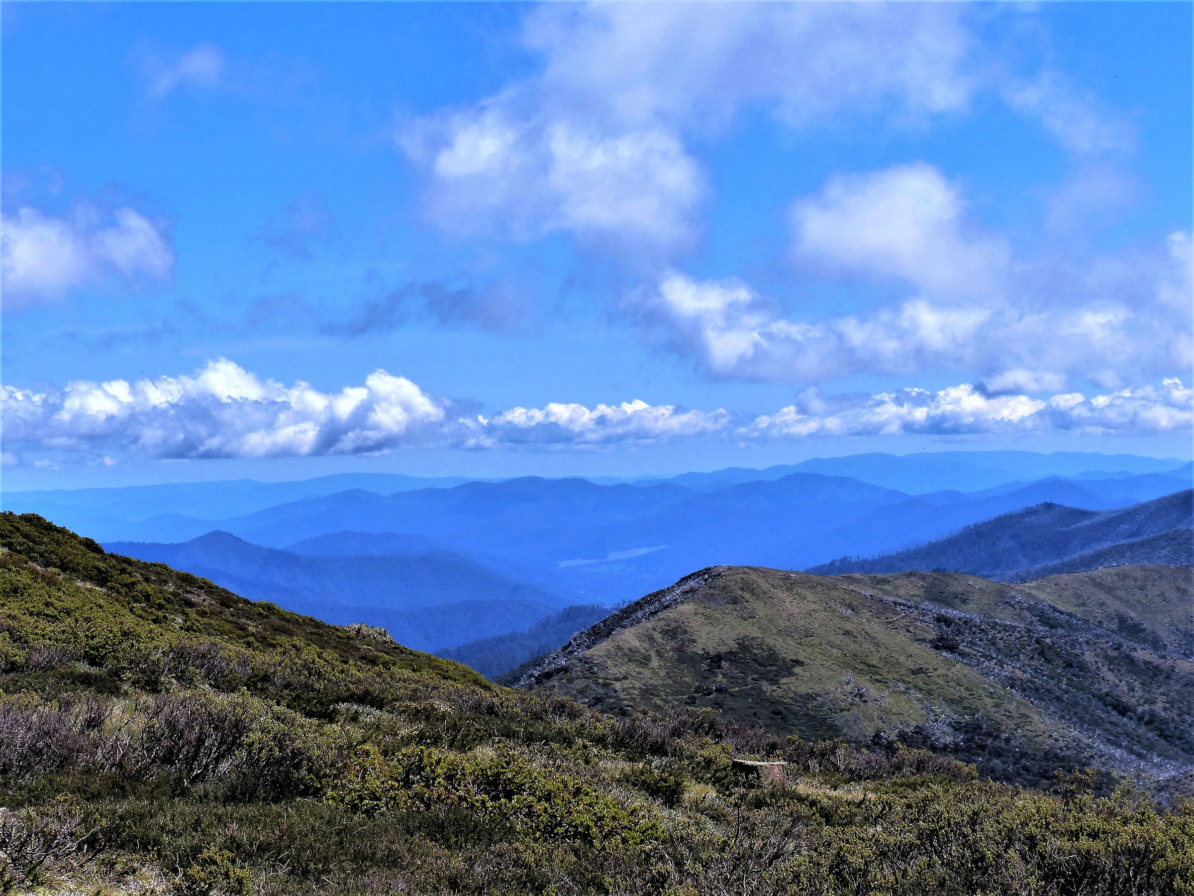
Danny’s Lookout near Mount Hotham, where Mount Buffalo presides over the northern horizon and Mount Feathertop seems a stone’s throw away, offers some of the best views in the mountains. Here, high above the snowline at 1705m, range after picturesque range of blue-green mountains recede into the distance — it simply takes your breath away.
While the chalets of Hotham, shrouded with snow during the winter months, make it one of the country’s favourite winter playgrounds, the mountains are spectacular at any time, and many enjoy a range of hiking trails from Mount Hotham throughout the year.
The area around Hotham has recorded 106 native floral species, including snow daisy, showy violet and Victorian buttercup, which turn the slopes into colourful displays outside of winter.
Past the chairlifts and chalets of Hotham, the Great Alpine Road takes you 12km to Dinner Plain, Australia’s only freehold land above the snowline.
Nestled among glades of snow gums, the village’s houses are all built of stone, timber and corrugated iron, but are each unique in their multi-dimensional shapes.
When the snow melts and ski resorts all but close, Dinner Plain is usually in full working order, with bars, cafes and restaurants open (COVID-19 permitting). When it’s not snowy, mountain-biking is popular here, as are wildflowers seen from array of well-marked trails.
Setting off from Dinner Plain it’s a windy 45km down to Omeo, as the landscape changes from alpine vistas to forested hills and lush grazing land.
Situated on Livingstone Creek, Omeo is a fascinating frontier town that was once the centre of one of Australia’s toughest goldfields. Gold was discovered in the Omeo region in 1851, and the town boomed. Omeo still boasts many goldrush buildings that you can see on a self-guided Heritage trail around town that reveals gems including a log jail and courthouse (1858–59), police cookhouse (1882), Lands Department Office (1872), and post office (1891).
Omeo boasts two pubs, the Hilltop Hotel and the Golden Age Hotel, both of which serve icy cold ales and hearty traditional hotel fare.
There are several interesting walks around town including the Oriental Claims Historic Area and Ah Fong’s Loop Walk.
At Dry Gully Creek about two-kilometres from Omeo is a suspension bridge built to honour miners who established the Livingstone Creek diggings. The bridge takes you to the heritage-listed Oriental Claims area, once one of the world’s largest gold-sluicing operations. Some 1600kg of gold is said to have extracted from the area and many mining remnants remain.
Ah Fong’s Loop Walk, also at the site, is a 1.5km trail along Livingston Creek sites worked by goldminer Ah Fong in the 1870s. Ah Fong struck it rich — his claim yielded about 170kg of gold — and he subsequently opened a shop in Omeo.
OMEO TO BAIRNSDALE, 120KM
Just over 25km from Omeo, passing undulating farmland and impressive stands of poplars along a moderately windy road, is Swifts Creek, situated at the junction of the Tambo River and Swifts Creek.
Another goldmining town established in the 1850s, Swifts Creek later became known for its timber industry, and is a pleasant spot to pause; the town features a supermarket, country pub, and a bakery featuring a wood fired oven built in 1886 that is still in use today.
Ensay, about 20km south of Swifts Creek, is another small town beside the lovely Tambo River.
Ensay’s classic country pub, The Little River Inn, was first granted a liquor license in 1847 and has held it to this day. The current pub was built in 1922 and provides food, accommodation, camping and (unpowered) caravan sites, a small store and post office.
Heading further southwards, the Great Alpine Road descends 52km along windy roads, hugging the Tambo River for part of its scenic journey through forests and pasturelands, to Bruthen.
Set at a fork in the road between Victoria’s high country, the hinterland region and the Gippsland Lakes, Bruthen has a number of historic buildings, shady gardens, the classic Bruthen Inn Hotel, and the Bullant Brewery, where craft beers are matched with dishes from an extensive menu.
Bairnsdale is just 27km south-east of Bruthen, and marks the end of the Great Alpine Road.
The largest city in the East Gippsland region, Bairnsdale, 281km east of Melbourne, is a busy provincial centre. Situated on the Mitchell River, which then flows into the extensive Gippsland Lakes system at Lake King, Bairnsdale might be the end of a Great Alpine Road journey, but it is also the gateway to the great natural beauties of East Gippsland — from the Gippsland Lakes to Croajingolong National Park — and a whole new adventure.
FAST FACTS
STAY
The Park Mount Beauty caravan park has powered sites from $42 per night. Situated on the banks of the Keiwa River a short stroll to the centre of town, the park features camp kitchens, indoor spa and riverside campsites, theparkmountbeauty.com.au.
Beechworth Lake Sambell Caravan Park has powered sites from $41. Situated by Lake Sambell, the park has easy access to the Murray to Mountains Rail Trail and many walking tracks. There are two undercover BBQ areas, children’s playground, mini golf and a kiosk, caravanparkbeechworth.com.au.
Lake Catani Campground at Mount Buffalo has camping sites suitable for caravans for $14 per night, only available from Melbourne Cup Weekend (November) to April inclusive. Pleasant camping under snow gums overlooking lake and alpine scenery. Showers and flushing loos. Bookings essential for peak periods. Book at parks.vic.gov.au.
Located on the banks of the Ovens River 7km from Bright, Discovery Parks – Bright (formerly Bright Freeburgh Caravan Park) has powered sites from around $40. Pool, camp kitchen, playground, leafy grounds with mountain views, discoveryholidayparks.com.au.
Swifts Creek Caravan and Camping Park has powered sites from $26.50 per night. Situated on the Tambo River, this small council park has showers, undercover BBQ area and children’s playground. Easy walk to town. Book by phoning Swifts Creek General Store on (03) 5159 4205.
FREE CAMPING
Smoko Campground, 8km from Harrietville, is a free camp on the banks of the Ovens River suitable for tents, trailer and caravans. There are picnic tables, a fireplace and pit toilet.
Ah Youngs Campsite is a free camping area in a grassy area near the banks of the Buckland River. With plenty of room for any size rig, it’s a nice spot for a swim. Toilets, fireplaces, BBQ's, pets are allowed. Nine kilometres from Porepunkah on Buckland Road, Buckland.
Hinnomunjie Bridge Camping Area in the Omeo Valley is situated on the Mitta Mitta River is a basic camp reserve suitable for tent, caravan and trailer-based camping. Open grassed area, fishing and swimming. Campers need to be self-sufficient as the site only provides one drop loo.


