
High Plains Drifting
Sheepyard Flat on the banks of the Howqua River, some 1300m below the summit of Mt Buller, makes a great destination in warmer months. There’s something for everyone, whether it’s fishing the Howqua’s crystal clear waters for an elusive trout, bushwalking its many tracks, horse-riding, or just taking some time out to soak up the natural beauty that abounds here.
With its stunning scenery, the area was made somewhat famous by the Man from Snowy River films in the 1980s. While I was never going to be a Tom Burlinson (except perhaps in my own mind), in a younger life I spent time horse-riding the Howqua and Mt Howitt area. While those days of youthful exuberance are now nothing more than a distant memory, the High Country still holds a special attraction for me and having traded my horse for a 4WD, I thought it worth dragging the van into the Howqua for a trip down memory lane.
--------------------
DOWN MEMORY LANE
Access to the Howqua is via Mansfield, three hours north of Melbourne. From here it’s a short drive towards Mt Buller to pick up the Howqua Track just outside Merrijig. This gravel 2WD road is fine for a van, although care is needed given the numerous blind corners, often corrugated from the heavy right foot of the many weekend warriors who visit the High Country to test their 4WD skills.
The area attracts a diverse range of visitors and being so close to Melbourne with good access, it is an extremely popular weekend destination. As a result, it is best to travel mid-week and avoid school and public holidays when it can be, as they say, ‘packed black’. The higher tracks are seasonally closed from June to the beginning of November making that a potentially quieter (but more inclement) time to visit.
Sheepyard Flat and several other nearby smaller campgrounds are the end of the road for your van as the tracks beyond become progressively steeper and rougher. The Sheepyard campground is an extensive grassy area studded with tall shady gum trees, all bounded by the Howqua River. Apart from basic toilets there are no other facilities, so plan to be self-sufficient while staying here.
A selling point for me is that dogs on lead are allowed in the Howqua Hills Historic Area (but not in the adjoining National Park). Regretfully, the opportunity to legally camp with your pets is becoming progressively more limited, with seemingly almost every scenic destination in Australia designated a no-go area when it comes to the fur-babies.
The campground abounds with birdlife, and you awake to a symphony of early morning calls from magpies, kookaburras, wattlebirds, and a wide range of smaller birds flitting through the bush on a mission to find breakfast. King Parrots are a common sight and being used to the occasional (misguided) handout from campers they often perch on your tent or van in hopeful expectation. Male King Parrots, with their brilliant red plumage have to be one of the showiest birds in the forest.
Also making up close and personal appearances around the campground are satin bowerbirds. From a distance the male can be mistaken for a common blackbird, but they are slightly larger and in certain light their plumage glows a deep iridescent midnight blue.
The Howqua is also home to the platypus, although I’m yet to be lucky enough to see one of these shy monotremes in the wild.
EXPLORING THE AREA
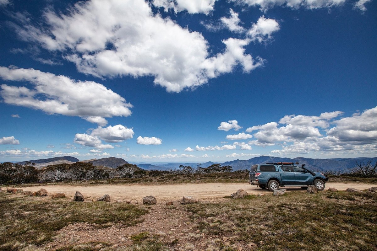
To properly explore the rugged snow gum clad high ranges surrounding the Howqua you need a 4WD and (ideally) the skills to use it. With most vans being towed by 4X4’s these days, caravanners have the equipment to visit some breathtaking locations denied to their two wheel drive brethren — even if their 4WD driving skills are minimal.
The Howqua Hills Historic Area was a gold mining precinct in the 1880s. While most of the infrastructure from those days has been erased by time and bushfires, some evidence still remains of the lengths the hardy miners went to in their pursuit of the precious metal. At nearby Tunnel Bend, a 100m tunnel was cut by hand into the bedrock to take water from the Howqua along a 4km headrace to a 63 foot waterwheel near Sheepyard Flat. The course of that headrace can still be seen running across the hillside above the campground. These days it is the path for a scenic walk, and joins the 1.5km Heritage Walk between Sheepyard and Frys Flat where a brick chimney, a remnant of the old gold processing plant, still stands.
Nearby Frys Flat, as well as being a popular camping area, features a hut build by Fred Fry as his home in the 1930s. Fred was a master bushman who built several other huts in the area while prospecting and packing supplies for fishermen and government agencies last century. Fred and his horse ‘Flour Bag’ were a regular sight in the valley, and a number of locations and tracks throughout the area bear Flour Bag’s name.
While the major 4WD tracks that criss-cross the valleys and high ridges can be easily traversed by a standard 4WD when dry (albeit possibly potholed and rough in places), they are narrow and need to be driven with care and a watchful eye for other vehicles. If there has been significant recent rainfall, it is best to keep to the main all-weather roads as tracks become soft and slippery and water crossings dangerous.
Perhaps the most popular destination in the area is the iconic Craigs Hut, arguably the most photographed mountain hut in Australia. Set on an open grassy ridge on the back of Mt Stirling with spectacular views across blue ranges receding picturesquely into the distance, it is easy to see why it was selected as a location for the Snowy River films.
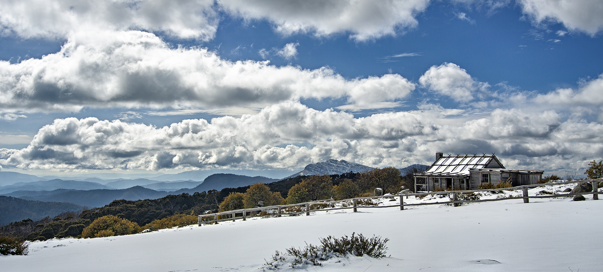
Originally nothing more than a film set facade, the hut fell into disrepair when abandoned after filming. With the release of the film, the site attracted numerous sightseers and the hut was rebuilt as a tourist attraction and a winter refuge for bushwalkers and cross-country skiers. Unfortunately, bark roofs don’t do well in bushfires, and Craigs Hut was destroyed by a wayward ember in 2006. Rebuilt in its present form in 2008 the hut continues to attract myriad sightseers and regularly forms a backdrop for wedding photos with the bride and groom choppered in from Mansfield or Buller.
While there are 4WD tracks that will get you from Sheepyard to Craigs Hut, those preferring to keep to roads more travelled should head back to the main Mt Buller Road and then follow Mt Stirling Road and Circuit Road to reach the hut. The short narrow access track to the hut is strictly 4WD but not particularly challenging (oncoming traffic being the major concern). While at the hut, look at the distinctive Mt Cobbler in the background. It is also known colloquially as Indian Head given it looks like a profile in recline with eyebrow, nose and lips. Why Indian Head? Perhaps this may have been something to do with the numerous American prospectors in the early gold fields who likened the profile to that on the American one cent coin.
Anyone in the Mansfield/Buller area after heavy snowfall and wanting to treat themselves to something special should think about asking the Mansfield chopper service to drop them at Craigs Hut with a pickup later in the day. Only a 10 minute hop from Buller’s low car park it’s not as expensive as you might think — and a bottle of bubbly sitting on the verandah of Craigs Hut, surrounded by pristine snow and not another person for miles has to be a magic experience!
Below Circuit Track is the King River, and providing you don’t mind driving through the river there is a great lunch spot at Pineapple Flat. From there take a scenic drive along the King Basin Road that follows the river east before picking up Circuit Track again. The short river crossing is usually only 400mm deep, but it’s a daunting prospect if you’ve never driven your vehicle through a river before. You will find several more shallow fords that cross the river along King Basin Road.
A little further around Circuit Track is Bindaree Road, another all-weather road that descends into the Howqua Valley below. Take the time to stop at Bindaree Falls for a 10-minute walk along a tree fern lined path to the base of the falls where you can stand behind a curtain of water that cascades over a rock ledge high above.
From Bindaree Falls proficient 4X4 drivers can continue on down to the Howqua and cross it to pick up 4WD tracks which eventually lead back Sheepyard. More conservative drivers should continue on around Circuit Track and retrace their steps back down Mt Stirling Road.
HEADING FURTHER AFIELD
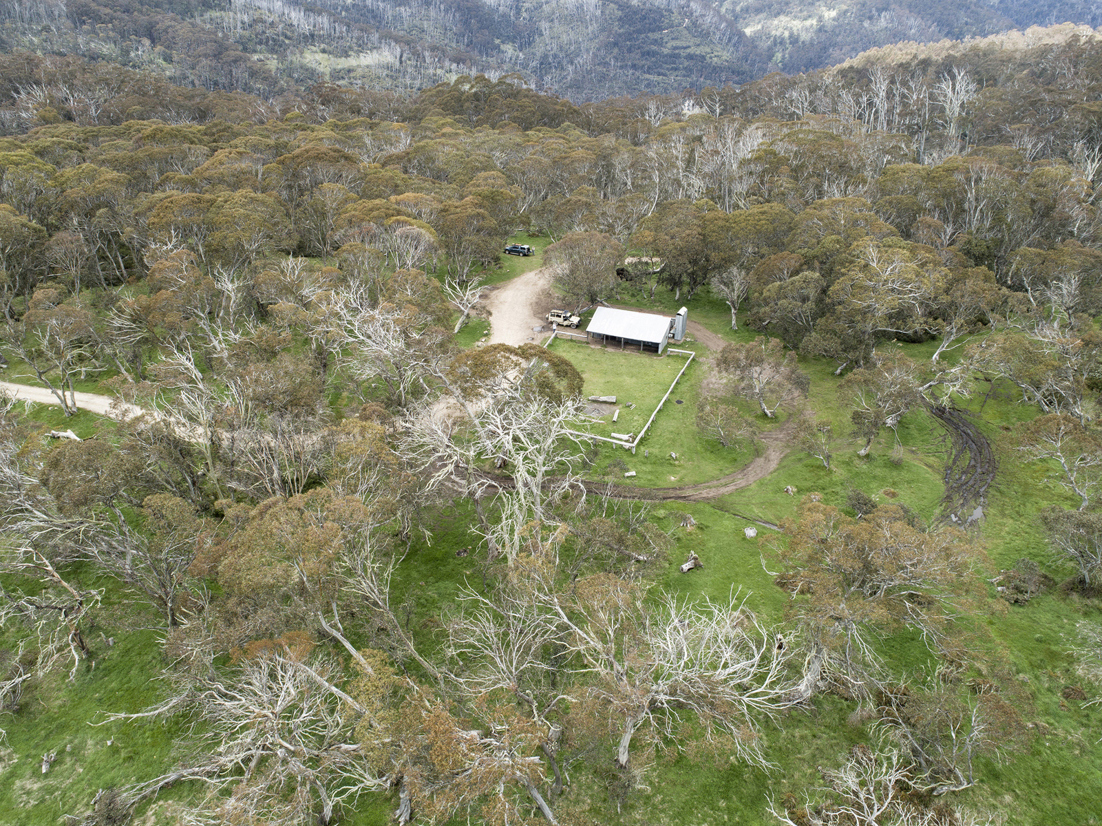
Another scenic day drive is Brocks Road, which follows the path of the Howqua before heading steeply up into the high ridges above the valley to skirt the impressive ramparts of The Bluff. At the top of the last climb out of the valley Bluff Hut sits in a clearing. The hut was originally built by the Stoney family in the 1950s to provide shelter on leases they held to graze cattle in the mountains. Destroyed by the same bushfire that claimed Craigs Hut, Bluff Hut was also rebuilt by Parks Victoria as a refuge for horse riders and bushwalkers. Anyone suffering withdrawal symptoms from a lack of phone coverage will find Bluff Hut has good reception with Buller’s communication towers across the valley.
From Bluff Hut the track becomes more challenging, often with deep ruts and pot holes that need to be negotiated carefully. While a slow drive, it is particularly scenic with large stands of old Snow Gums that have survived decades, perhaps centuries and interspersed with occasional expansive views across the ranges.
Set amongst the picturesque Snow Gums with their colourful bark and twisted trunks is Lovick Hut, built by the Lovick family who also ran cattle here until forced out due to environmental concerns over damage their stock caused to the fragile Alpine environment. Now a refuge for park users it remains, like Bluff Hut, a popular overnight destination with bushwalkers and horse riders.
A couple of kilometres on from Lovick Hut is arguably one of the best views in the High Country. The aptly named Picture Point looks out over a sheer drop into the Howqua Valley below with a vista across to Mt Buller and beyond. The track up to Picture Point is usually quite rough depending on recent weather and maintenance. With dirt scoured out by rain and constant vehicle use, it can be like driving up a rocky creek bed. For the less confident 4X4 users it is probably best to stop and take your views at Helicopter Spur, a helipad just before the climb to Picture Point.
The track past Picture Point is very potholed and slow, but the scenery compensates. Visitors pass a massive Snow Gum that, as well as having a bit part in the Snowy films, has also been recognised by the National Trust. Known as the ‘King Billy Tree’, this snow gum with a 3m diameter trunk is thought to be 200-years-old.
Eventually the track rejoins Brocks Road, a reasonable gravel road that leads all the way back to Sheepyard. The junction with Brocks Road is near the mountain hideaway of Buttons, an eccentric (but seemingly harmless) recluse who lives off the land hunting deer with handmade spears. Like something out of the movie Deliverance, Buttons has been known to pay unannounced (and no doubt unsettling) night-time visits to campers on this remote saddle.
Brocks Road descends and crosses the Jamieson River (by bridge) before travelling up and over the ridge that divides the Jamieson and Howqua Valleys. Not far from the bridge, there is a turnoff to a track which descends steeply for a couple of hundred metres to a river crossing that leads to the Upper Jamieson Hut in a clearing on the far side (this crossing should not be attempted if the river is running strongly). The hut, built by Fred Fry in the 1930s and restored by Parks in 2008, is picturesquely located on the banks of the Jamieson River, making it a great place for a lunch stop or just a tea break.
In the years since I last visited Sheepyard Flat my memories of how inviting it can be as a getaway destination had faded somewhat. However, after this return visit I’ve decided it certainly won’t be my last, as it is an ideal place to soak up the natural beauty the Howqua Valley displays in abundance. It’s truly rare to find such a largely unspoiled destination with so much on offer, only four hours from Melbourne.
FAST FACTS
WHERE
Sheepyard Flat is approximately 4 hours north of Melbourne
WHEN
November to May is the best time to travel. Avoiding this popular destination on weekends and holiday periods, or after heavy rain is recommended. Tracks in the surrounding ranges are seasonally closed between the beginning of June and November.
DRIVING CONDITIONS
Access to Sheepyard Flat is by a good all-weather gravel road suitable for a standard caravan and two-wheel-drive vehicles. Most other tracks in the area should be considered 4WD only as they can be rough and potholed depending on weather and maintenance. Roads and tracks are narrow and winding. Be alert for oncoming traffic. Reducing your tyre pressures (25–30psi) will improve ride comfort.
Anyone planning to explore the myriad 4WD tracks of the High Country should have experience in the proper use of a 4X4 vehicle and carry appropriate recovery equipment.
SUPPLIES
The nearest source of medical attention, fuel and supplies is Mansfield (population 5000) approximately 45 minutes away. Water drawn from the Howqua River should be boiled before drinking. Visitors need to be totally self-sufficient during their stay.
NAVIGATION
Detailed paper maps should be carried, but electronic maps (such as Hema) with in-dash display are a great asset as they greatly simplify navigation of the spider web of tracks that criss-cross the High Country.
PETS
Dogs (on lead only) are permitted in the Howqua Hills Historic area (which includes Sheepyard Flat and other adjacent campgrounds). Dogs are not permitted in the National Park
INFORMATION
Parks Victoria, Mansfield
Ph: 03 8427 2076 (note that the office is not always manned)
Web: parks.vic.gov.au/places-to-see/sites/sheepyard-flat-south-camping-area, parks.vic.gov.au/places-to-see/parks/howqua-hills-historic-area


