
Ghost Towns of the Goldfields
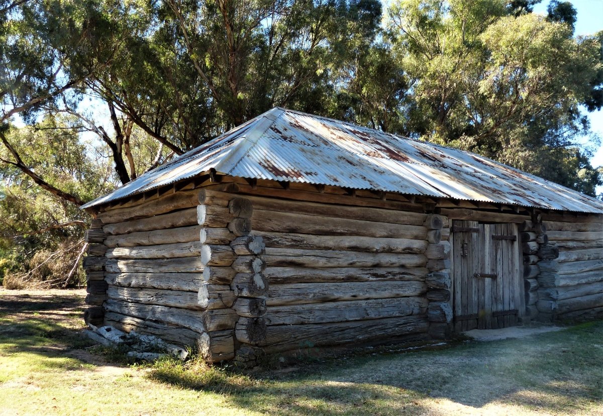
Stoney Creek School, near the old goldmining town of Talbot in central Victoria, closed in 1916, and its buildings were demolished long ago.
But here, in an eerie, abandoned schoolyard surrounded by thick bush, are the ruins of a rock garden shaped into a large map of Australia, built around the time of federation. This poignant reminder of a ghost town and the children who once lived here is just one of the many fascinating hidden secrets of central Victoria’s goldfields region.
The names Bendigo and Ballarat echoed around the globe after gold was first discovered in 1851, igniting a rush that attracted hopefuls from around the world: by the end of 1853, more than 200,000 people had flocked to the goldfields, and within a decade Australia’s population had trebled.
Victoria’s goldfields proved to be extraordinarily rich. According to the Victorian Mines Department, the state produced more than 60-million ounces of gold between 1851 and 1896 — and that’s only what was recorded. Today, gold is around $2600 per ounce.
While goldrush cities Ballarat and Bendigo feature their rich history at places such as Ballarat’s exceptional open-air museum Sovereign Hill and Bendigo’s Central Deborah Mine, getting off the beaten track across the backroads of the goldfields region makes for a fascinating journey into the past.
The search for gold left the countryside pockmarked with great mounds of earth known as mullock heaps, which are evidence of deep-lead mining. Driving country roads, you discover creeks scarred from sluicing, the ruins of old puddling machines, the chimneys of gold smelters, and abandoned gold mines.
The Stony Creek ruins are deep in the bush about 8km from Talbot, which is one of Victoria’s best-preserved goldrush towns. It is a chaos of shops, businesses and, it’s said, around 100 hotels and sly grog shanties from the 1850s and ‘60s, when the population peaked at around 30,000 — today Talbot has a population of around 450.
The town’s Scandinavian Crescent comes to life on the third Sunday of each month though when hundreds of people hit town for the Talbot Farmers’ Market, regarded as one of Victoria’s best.
A stroll around Talbot reveals Victoria’s oldest functioning post office, former Primitive Methodist Church, public library, town hall, old banks, a former courthouse, and Courthouse Hotel, built in 1859, which serves traditional pub fare.
Gold was discovered at Opossum Gully in Amherst, 4km north-west of Talbot, in 1854. A rush began and the Adelaide Lead opened. Amherst was situated in the middle of a reef of gold said to be 11km long and 1.5km wide.
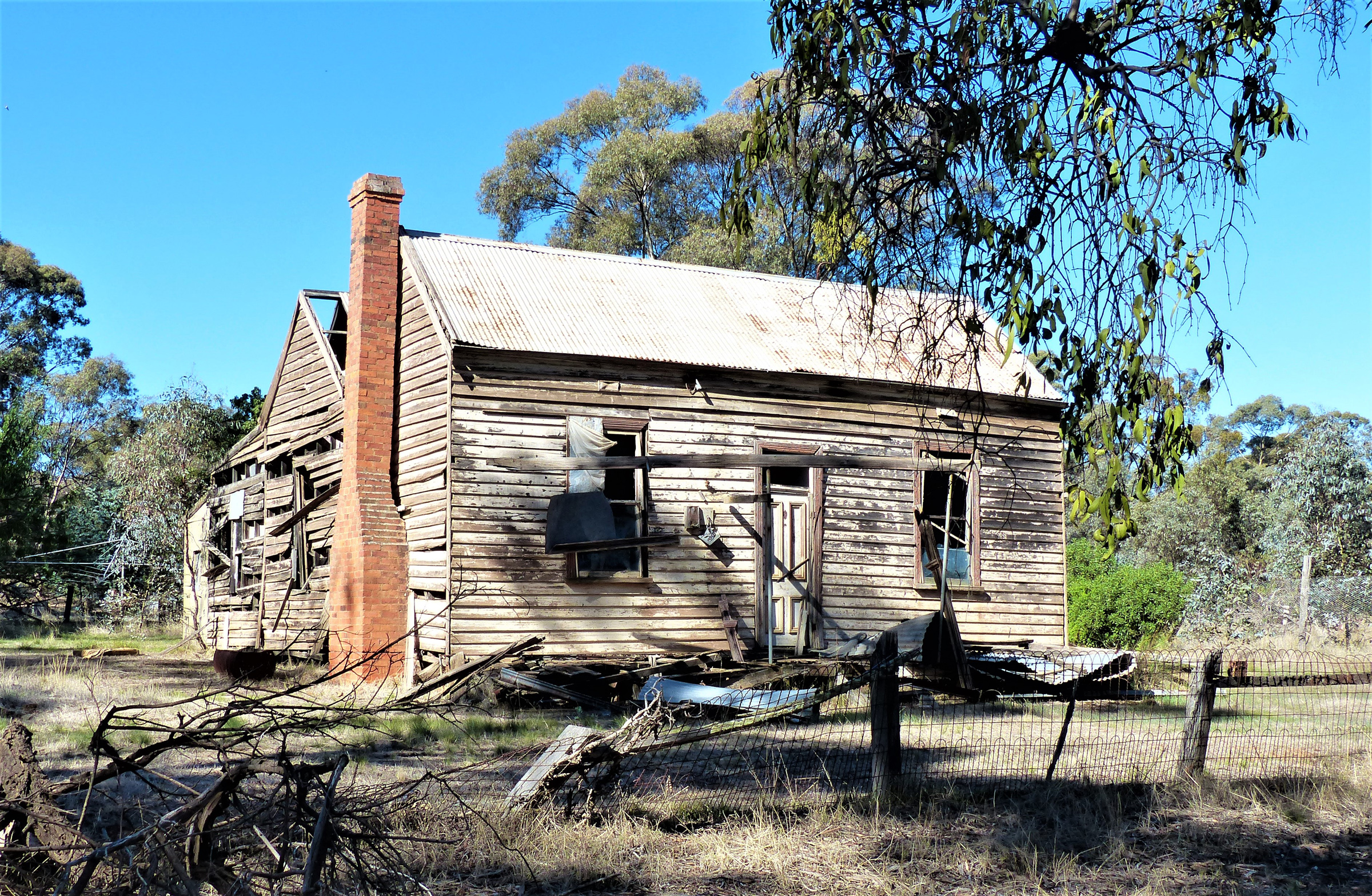
Amherst’s buildings once included seven general stores, an inn, and a hospital, but they are long gone. Like so many Victorian ghost towns, the story of Amherst is the story of a town that sprang to life with the arrival of gold-hungry prospectors, and then all but disappeared when the gold ran out.
A walking tour of Amherst reveals Chinese baths still visible today, carved into the ground by miners at a site thought to be a joss house, bluestone culverts, and Amherst’s old cemetery, which reveals a snapshot of the harsh lives of miners and their families.
Three kilometres from Amherst is the Big Reef, a quartz outcrop said to be the largest single piece of pure quartz rock in the world. Quartz reefs are the primary sources of gold, and miners at Amherst, where a terrifying shaft leads deep into the earth, thought they’d struck it rich. But they didn’t find a thing — this reef was one of the few found that didn’t bear gold.
More interesting sites around Amherst and Talbot include ancient Indigenous drinking wells and, on Pollock’s Road, a shelter tree, which is a large hollowed-out gum said to be about 700-years-old and used by the Dja Dja Warrung people as a shelter for women giving birth.
The 1675ha Paddy’s Ranges State Park, which dominates the area around Talbot, is not only home to more than 140 species of native birds and 230 recorded species of wildflowers, but a good place to view more relics of gold mining days.
Talbot to Maryborough via Majorca, 35KM
It’s been more than a century since prospectors toiled in the gold mines around Majorca but driving towards this ghost town past undulating farmlands you still see huge white mullock heaps around this town which was once famous for its mines and myriad hotels. The last hotel closed in 1936.
From 1863, some 15,000 diggers worked feverishly around the hundreds of poppet heads that once dotted the landscape. Today it’s difficult to imagine that Majorca once boasted a thriving commercial area filled with more than 250 shops, stores, restaurants, hotels, billiard salons, theatres, general stores, and a telegraph office.
Due to the ravages of bushfires, today nothing much remains of Majorca save the restored town hall, former London Charted Bank, a derelict haberdashery, a church, and a few scattered houses.
From Majorca it’s 8km north to Carisbrook, worth the detour on the way to Maryborough to see the town’s circa 1852 log jail, and some fine bluestone buildings.
Carisbrook was established in 1851 as a police camp to oversee convicts working on surrounding farms, and once had 17 pubs. Today it’s one hotel, the Britannia, serves traditional fare, and Carisbrook also features a terrific little bakery well worth a pitstop.
Carisbrook is 7km east of the large town of Maryborough, population around 13,000, which boasts a feast of colonial architecture including a railway station so grand that in 1895 visiting American author Samuel Clemens (Mark Twain) called it “a railway station with a town attached.”
Although Maryborough is hardly a ghost town — it is the bustling epicentre of Victoria’s Central Goldfields region — this attractive town makes an ideal base to explore the area.
Maryborough to Dunolly, 22KM
Throughout the goldfields, place names are clues to the past. They can relate to the landscape, such as Pig Face Gully and Bald Hill, and gold mining terms, including Crusher’s Gully and Lucky Strike Reef. Other times names and nicknames were used too, including Granny Thomas’s, Drunken Scotchman’s, and Dirty Dicks, while trades are represented at places called Sawpit Gully and Slaughterhouse Hill.
Some places are named after events, such as Pickpocket Hill, Burying Ground Flat, Chokem Flat, and Bung-Eye Gully. In a darker turn, Murderer’s Hill, just north of Maryborough on the Bridgewater-Dunolly Road, is so named as it was the site of an unsolved double murder of two men in 1857.
Murderer’s Hill is not far from the Waanyarra Historic Township, set amid the Dunolly State Forest 30km north of Maryborough. Waanyarra became a bustling town after gold was discovered in 1852 and was popular for the large number of alluvial nuggets found here at places called Mosquito and Madman’s Leads.
In the 1860s Waanyarra supported several hotels and shops, a school, post office and police camp. Today little remains of this ghost town except an isolated yet well-cared for cemetery and long-abandoned Morton’s ‘Welcome Inn’, built by former Irish convict Michael Morton in 1852.
This wonderful old stone building, said to be built to resemble Morton’s former home in County Tipperary, is situated on Morton’s Lane where these days the only sounds you hear are the chirping and warbling of birds.
Waanyarra is a peaceful spot to try your luck prospecting with a metal detector, hike the 7km Waanyarra Walk, and explore kilometres of forest tracks.
From here it’s 14km to Dunolly, once a chaotic gold rush town of around 45,000 people at its peak in 1858.
The historic town you see today, featuring a parade of buildings from the years Dunolly’s main street, called Broadway, buzzed with theatres, bowling alleys, pubs, brothels, and scores of shops, is the fifth site of the town of Dunolly according to historian John Tully from the Goldfields Historical and Arts Society.
“Gold would be discovered further along Burnt Creek, which runs through the area, so prospectors, hoteliers and storekeepers simply packed up their canvas houses and moved the town upstream or downstream,” he said.
The Goldfields Historical and Arts Society, established in 1960, is housed in the Dunolly Museum, and is an essential stop on any goldfields journey. The museum features a treasure trove of more than 10,000 exhibits, including goldmining equipment, photographs, firearms, copies of many gold nuggets found in the area, and curious items such as a prostitute’s brooch, which hides a whistle for emergencies.
John is a fount of information on this fascinating region, telling me there are around 50 ghost towns within a 30km radius of Dunolly alone, many of which are buried deep in the bush. These include Inkerman, near Moliagul, which was once home to 16,000 people. Now there’s nothing at all at the site.
A Greek settlement near Carisbrook is another ghost town in the area where, according to John, you can see the remains of chimneys and raised floors. Further on, Tunstalls near Bealiba is another forgotten gold rush town, where about 1000 people lived in 1867.
“Today as you walk along what was once Tunstalls main street, which is now dense bush, you see the mounds of chimneys and cellars and, curiously, oyster shells at the site of one of the town’s hotels — it was clearly a wealthy place if oysters were transported this far from the coast,” John said.
Dunolly is 180km north-west of Melbourne, so anything in this area is a long way via horse and cart for some oysters.
Because so many ghost towns in the area are difficult to find, the Goldfields Historical and Arts Society runs tours to them alongside tours closer to town including the Lesser-Known Places of Dunolly tour and popular Brothels of Dunolly tour.
Dunolly to Tarnagulla, 16KM
From Dunolly its 16km north-east to Tarnagulla, passing paddocks where sheep graze, fields of canola, and pockets of bush that display the intense gold mining in the area.
The forest and woodlands of the Dunolly region are dominated by Box and Ironbark eucalypts. During the spring and summer months, the bush is colourful with wildflowers such as cranberry heath, twiggy bush pea, gold dust wattle, catsclaws grevillea, and delicate native orchids.
Cocooned in a time warp, Tarnagulla has a population of around 150. Back in 1865 the town’s population was around 20,000, when Tarnagulla had two breweries, a newspaper, nine general stores and four hotels.
Today there are several old banks, churches, and closed-down shops, the Victoria Hotel and Theatre, which now operates as the community hall, and the Golden Age Hotel, dating from 1857.
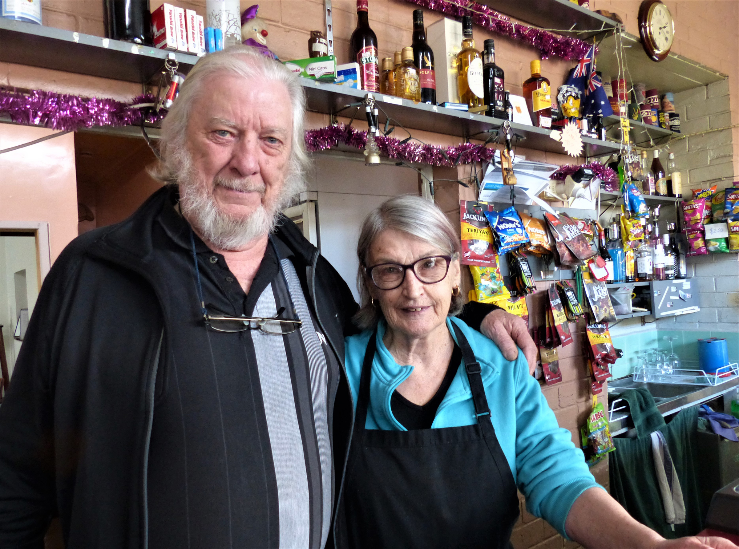
John and Mary Lavery have been running the Golden Age, originally known as Foo’s Family Hotel, for 35 years. This friendly country pub, closed for ten months due to COVID restrictions, has now reopened, and John and Mary are serving parmas ($25), local porterhouse steak ($30), and their famous mixed grill ($25).
Tarnagulla to Timor via Moliagul, 29KM
Moliagul hit the headlines in 1862 when the 67.5kg Welcome Stranger, the world’s largest nugget of gold, was found by John Deason and Richard Oates at Bulldog Gully, 2km west of the town.
Gold was first discovered in Moliagul in 1852, and more than 4000 diggers rushed to the area. During its halcyon days in the 1850s and ‘60s the town bustled with more than 16,000 people. Moliagul’s post office opened in 1858, the Anglican Church in 1865, and state school in 1872.
The town also boasted a police camp, a blacksmith, and a butcher shop and, it’s said, eleven rowdy hotels. All you can hear today is the bleating of sheep that graze across paddocks that were once busy streets and magpies warbling among the gum trees.
The Mount Moliagul Hotel (closed) is the only remaining pub in Moliagul. An old church and state school buildings, a lonely cemetery, and a scattering of houses remain, as does the site of the cottage, now marked with a memorial, where the Reverend John Flynn, founder of the Royal Flying Doctor Service, was born in 1880.
Heading back towards Maryborough along the Dunolly-Timor Road, you come across Timor, a place that was once so busy that no less than eight Cobb & Co coaches once travelled between here and Maryborough every day.
More than 18,000 diggers rushed here after gold was discovered in 1854 so by the 1880s, Timor’s streets thronged with 30,000 residents who slaked their thirsts at 38 hotels. The town’s mile-long main street was busy with two banks, several large stores, three butchers and three bakers, a post office, four churches, and a police station.
On the east side of town is a site that in 1856 was called Chinaman’s Flat township. This was intended to be a grand town with streets called Regent, Piccadilly (which had a Theatre Royal), Pall Mall and The Strand. Chinaman’s Flat even had its own newspaper. Just up the road, Central Chinaman’s township once boasted four hotels.
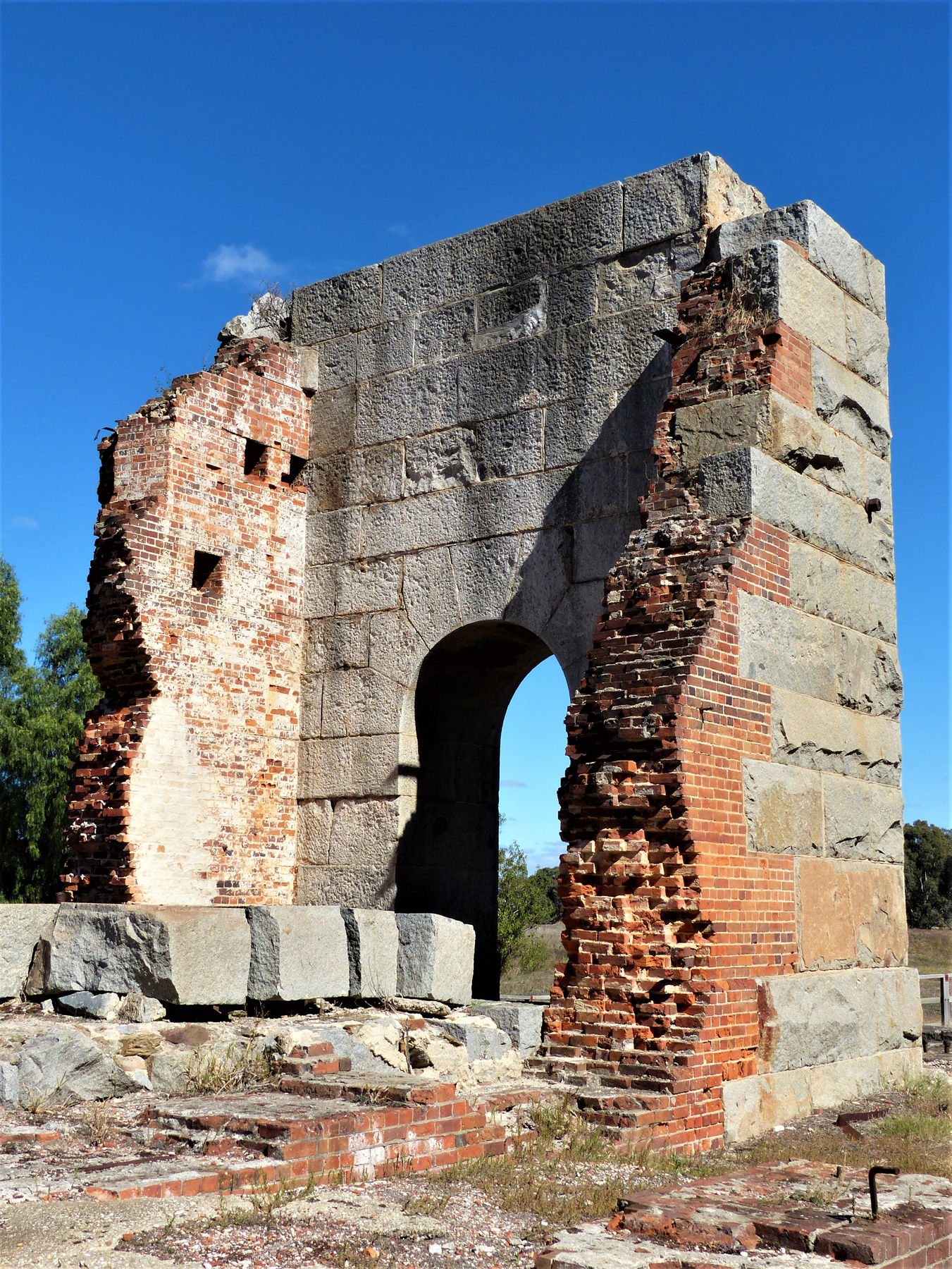
In 1874 a huge Cornish steam engine was installed at Timor’s Grand Duke Mine, capable of pumping 2000 gallons of water per minute from the mine, which produced a staggering six tonnes of gold over 27 years.
Today little remains to indicate Timor was once a boomtown except the ruins of the Grand Duke mine, a landscape covered with mullock heaps, wide bluestone street kerbs, an old store, and police lock-up, and circa 1873 primary school, which still operates.
Around this region are places with evocative names such as Goldsborough, Emu, Wild Dog Diggings, Mount Hooghly, Archdale, Bealiba, Rheola, and Bet Bet — the more you explore Victoria’ Central Goldfields, the more there is to discover.
Yes, there's still gold
Gold hasn’t disappeared from the landscape — the Central Goldfields region is regarded as one of Australia’s premier gold detecting regions, and gold continues to be unearthed in the area. These include some biggies, including the 27.2kg Hand of Faith nugget found near Kingower in 1980, a 4.1kg chunk found in 2016, and a 2.5kg nugget unearthed near Dunolly.
That’s just a few known finds as the majority of prospectors understandably keep their Eureka moments to themselves.
Maryborough’s Coiltek Gold Centre supplies the latest gold detectors and runs regular prospecting tours. W: coiltek.com.au.
To fossick in Victoria, you need a current fossicking permit known as a Miner’s Right, which are $25.55 for ten years from the Victorian Government’s Earth Resources (earthresources.vic.gov.au), selected tourist information centres and prospecting equipment shops, including Coiltek.
Fast facts
- Maps of walking tours of both Talbot and Amherst are available at the Talbot Arts and Historical Museum, along with directions to Stoney Creek and the Big Reef at visittalbot.com.au.
- The online Walking Maps website, sponsored by Victoria Walks and Vic Health, lists many ghost town walks to download, including Majorca, Dunolly, and Tarnagulla, and can be found at walkingmaps.com.au.
- The Central Goldfields Visitor Information Centre in Maryborough has maps and brochures of Maryborough and surrounding towns, including historic town walks. Head to centralgoldfields.vic.gov.au.
- The Dunolly Museum is open Wednesday and Friday from 9am–3pm, and occasionally on Saturday and Sunday afternoons 1:30–4pm if there are enough volunteers to man it. Admission adults $4, children free. W: dunollymuseumsite.wordpress.com.
Stay
- Maryborough’s Golden Country Caravan Park has powered ensuite sites from $40 per night. Inground pool, camp kitchen, playground, TV and recreation room, cabins, and motel units also available. W: goldencountry.com.au.
- Maryborough Caravan Park has powered sites from $39 per night. Situated on Lake Victoria with a short walk to town the leafy grounds include camp kitchen. It’s pet-friendly, and there’s a playground for kids. W: maryboroughcaravanpark.com.au.
- The Dunolly Caravan Park has powered sites for $33 per night for two people. Situated beside a pretty lake, it’s within walking distance of the main street. There are clean facilities, and a woodfire pizza oven in the communal area, which is fired up on Friday nights. W: dunollycaravanpark.com.au.
- The peaceful Tarnagulla Recreation Reserve has caravan sites (none are powered) for $5 per night. Just pull in and the caretaker, who lives on site, will find you. Coin-operated showers and toilets are also there. W: loddon.vic.gov.au.
Free camping
- The Paddy’s Ranges Campground at Adelaide Lead, 12km from Maryborough, is located within Paddy’s Ranges State Park. The large campground includes picnic tables, fire pits and woodfire BBQs, and toilets.
- Waanyarra Recreation Site is a large, cleared area in the Dunolly State Forest, popular for camping, gold prospecting and bushwalking. The picnic area has tables, wood fire barbecues and an undercover area.
- Moliagul Campground is a short drive from old gold diggings. The campground is situated in the middle of Moliagul, and has an undercover area, picnic tables, electric barbecues, and toilets.
- Bealiba Reservoir Recreation area is ideal for camping, fishing, and bushwalking. There are picnic sites and fire pits around the small reservoir, and non-flush toilets.


