
East Gippsland
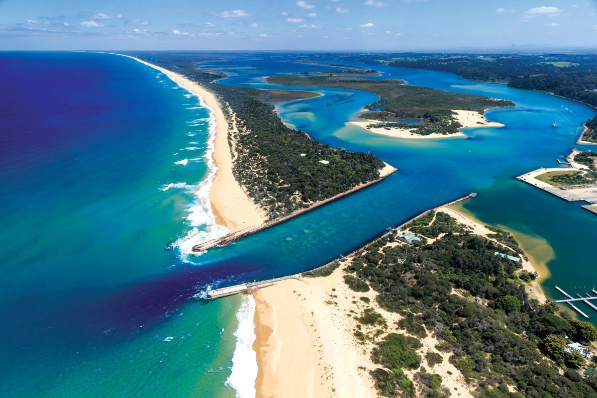
Lakes Entrance has been unashamedly geared towards tourism since holidaymakers called it by its original name, Cunninghame, in the 1870s.
Visitors once travelled to Cunninghame by train from Melbourne to Bairnsdale, a 280km journey, and then by coastal steamer another 40km east.
By the dawn of the 20th Century, the town, situated at the entrance to the Gippsland Lakes and the northern end of Victoria’s magnificent Ninety Mile Beach, boasted many guest houses catering to holidaymakers.
These days there’s no end of motels, apartments and caravan parks for travellers to choose from in the town, which was renamed Lakes Entrance in 1915.
Lakes Entrance is home to one of Australia’s largest commercial fishing fleets, and is a good place to stock up on fresh seafood before journeying further north.
One trawler, the Karumba Gulf, has been an institution at the town’s wharf for many years. After a night of fishing, its haul of seafood is sold straight from the boat. On the day we visit this including crabs, mackerel, prawns and squid.
Secret sites
Beyond Lakes Entrance, heading north, stretches Cape Conran Coastal Park and Croajingolong National Park, which feature magnificent swathes of wilderness and golden beaches generally devoid of human footprints.
From Lakes Entrance it’s 46km north to Lake Tyers, driving through countryside that is surprisingly verdant in early autumn, following the hot summer months.
Lake Tyers is confusingly made up of the lake itself, the small town of Lake Tyers Beach, and the Aboriginal Trust land known as Bung Yardna, which is not accessible to the general public.
Originally the land of the Gunaikurnai people, Bung Yardna became home to Aboriginals from across Victoria who were forcibly removed from their homelands during the 1800s.
This region contains many Aboriginal sites, including shell middens, scarred trees, occupation sites, burials and axe-grinding grooves.
The Lake Tyers State Park, which covers 7100 hectares, extends from Lake Tyers Beach to Mount Nowa Nowa. Tall eucalypt forests surround the northern shores of the lake, and a sand spit divides placid lake waters from the pounding ocean waters of Bass Strait.
Amidst the mountains
From Lake Tyers it’s 20km north by road to Nowa Nowa, an historic timber town that is now home to several art galleries.
A network of hiking trails at Nowa Nowa include the 1.2km Sculpture Walk, 1.4km Boggy Creek Walk, and 4.3km Rail Ramble on part of the East Gippsland Rail Trail, which takes you to an old trestle bridge.
Orbost, 40km east of Nowa Nowa, is a small town with a big history: situated on the legendary Snowy River, the area around Orbost was settled in the 1840s, and the town from the 1870s.
This bustling country town has a rich heritage of riverboats and steamers, gold, agriculture and timber milling, and is ideal for a pitstop.
First stop is an original circa 1870s pioneer’s hut relocated from the upper Snowy River and now home to the tourist information centre, where helpful staff tell us all about the region.
Orbost features some cheery cafes, a couple of bakeries, a butcher, two pubs, and two supermarkets to stock up on supplies.
The Snowy River starts as an icy mountain stream on the slopes of Mt Kosciusko in NSW, flowing northwards before swinging south into Victoria and entering the sea at the sleepy seaside town of Marlo, 500km from its source.
Fisherman’s friend
Not quite halfway between Melbourne and Sydney, Marlo, 15km downstream from Orbost, boasts sheltered waters ideal for swimming and river, estuary, lake and ocean fishing, where anglers reel in mullet, silver trevally, flathead and bream.
The Marlo Hotel has been the epicentre of town since 1886, back when Marlo was busy with steamers and schooners regularly ferrying agricultural produce between Orbost and Melbourne.
Perched on a hill overlooking the silvery Snowy River estuary, the hotel has wide verandas where alfresco dining includes local beef and seafood.
Many enjoying the pub’s big seafood platters have driven 18km from Cape Conran’s Banksia Bluff campground, part of the Cape Conran Coastal Park, 11,700 unblemished hectares of heathlands and woodlands fronting 60km of ruggedly beautiful Bass Strait beaches.
In 1881 the cargo steamer SS Ridge Park, laden with essentials for the region’s pioneers — which included French wine and German pianos — struck the aptly-named Beware Reef, 5km offshore from Cape Conran.
Those who perished in the shipwreck are buried at Sailors Grave, a sheltered cove at the southern end of spectacular East Cape Beach near Banksia Bluff.
Despite its unhappy past, Sailors Grave is popular with travellers for a picnic and splash in sparkling waters in a locale that’s been popular for millennia: there are Aboriginal shell middens nearby.
From our campsite it’s just a few minutes' stroll through the surrounding bush to the long sweep of East Cape Beach, where we set off for a seaside saunter.
Pelicans, petrels, oyster catchers, Pacific gulls, cormorants, egrets, osprey and sea eagles call the region home, and we see some of them as we stroll along the pristine sweep of pearly-white sands.
This veritable Eden supports around 300 recorded plant species and is a protected habitat for a whole slew of wildlife, including wombats, wallabies, echidna, platypus, bandicoots, possums, sugar gliders, potoroos, goannas and Australian fur seals.
The Conran Nature Trail winds to sandy beaches, rock pools, woodlands, lookouts and boardwalks, and gravel roads meander
through the bush to isolated spots such as the Yeerung River, popular for kayaking along tea-coloured waters.
Since Parks Victoria assumed direct management of Cape Conran Banksia Bluff campground last year, the campsite is unfortunately no longer manned by management who live onsite, as it had been previously.
This means that at around 4pm — just when caravans might start rolling in for the night — staff knock off and leave and campers are apparently expected to be online and pre-book before their site they arrive.
From Cape Conran we decide to head north along the Cabbage Tree-Conran Road towards the Princes Highway. Along here is the Cabbage Tree Creek General Store and it is a real find — you can feast on homemade pies, old-fashioned milkshakes, and taste quirky locally-made chocolate called Wombat Poo.
Lighting the way
From here it’s 48km northeast to Cann River. Along the way we pull off the highway for the 21km drive to Bemm River, population 70, on the shores of Sydenham Inlet.
This secluded spot, regarded as among East Gippsland’s premier fishing destinations, is also a favourite with birdwatchers and bushwalkers, who appreciate the natural beauty and prolific wildlife of the area.
Nestled between the inlet and the sea, Bemm River has a pub, a store and a caravan park. No petrol is sold here, so it’s wise to stock up before visiting.
Cann River is a busy petrol refuelling spot on the Princes Highway, and an ideal place to explore the 88,355-hectare Croajingolong National Park, which stretches around 100km from Sydenham Inlet to the NSW border.
Point Hicks, site of Point Hicks Lighthouse, is one of the highlights of the park. A twisting road, mostly gravel, snakes 46km through the bush from Cann River to Point Hicks.
Unless you’re planning to camp at Point Hicks’ Thurra campground for at least several days, consider leaving the rig at Cann River — council-run Cann River Rainforest Caravan Park is free for up to 36 hours — and doing a day trip to see the historic Point Hicks Lighthouse.
Or, better still, consider a relaxing sojourn at the lighthouse.
As we are passing through dense bush on the one-hour drive we see wallabies hop through the bracken, a wombat ambling across the road, and a metre-long lace monitor basking on a sunlit bank.
More than 300 species of birds sing across the forests of Croajingolong, including cockatoos, kingfishers, bowerbirds, emu-wrens, lyrebirds and lorikeets.
The Thurra River and Muller Inlet campgrounds, 3km from Point Hicks Lighthouse, provide opportunities for isolated bush camping, with basic facilities.
Thurra River has 46 sites, some suitable for caravans, while Mueller has just eight. Walks abound including the Dunes Walk, where thrill-seekers plummet down 30m-high sand dunes into the Thurra River below.
Following a track from the Lightstation Reserve gate, visitors can hike along the shore of idyllic Honeymoon Bay to the lighthouse, which stands like a sentinel in the wilderness. But we can drive in, as we’re spending two nights at a lighthouse keepers’ cottage.
Built from 1887 Point Hicks lighthouse sits majestically on a craggy promontory buffeted at times by gales up to 125km/h — there’s nothing between here and Antarctica.
Lighthouse keepers Paul Harper and Suzanne Davies show us to our Victorian-era cottage, which has three bedrooms, a comfy living room, dining room, old-style kitchen to cook up a storm, and veranda with incredible views of the ocean and a cairn dedicated to Captain James Cook.
Captain Cook, aboard the Endeavour, passed Point Hicks in 1770, becoming the first British navigator to see this part of Australia.
In the morning the sun shines and the ocean is like a millpond. A wallaby hops along the veranda and, offshore, a pod of resident seals frolic around the boulders near the cairn.
A whale of a time
Victoria’s east coast is a whale migration highway, and humpbacks and southern right whales are the most commonly seen whales along Australia’s coastline.
Each year between April and November, the east coast comes alive with the spectacular acrobatic displays of humpback whales. After a summer of feeding on krill in Antarctic waters, the whales migrate north to sub-tropical waters where they mate and give birth.
The majority of humpbacks in Australian waters migrate north from June to August, and back towards the Southern Ocean from September to November.
Southern right whales are similar to humpbacks in that they feed in Antarctica in the summer and then migrate north to Australia to breed and give birth.
According to Paul and Suzanne, up to 15,000 whales pass Point Hicks during annual migrations.
After a restful lighthouse stopover we traverse the bumpy road back to Cann River, where we head north to discover more of Croajingolong’s charms.
The park is accessed from a maze of gravel roads from multiple points along the Princes Highway, including Wingan Inlet Beach, 46km from Cann River (including 34km of dirt road).
Another early adventurer, George Bass, named the site Fly Cove when, exploring the east coast in 1797, he sheltered here for two weeks — possibly slapping away plenty of flies while he was there.
At this remote spot the golden sands of Wingan Beach curve along the coast, a camping area (suitable for tents, camper vans and camper trailers) is nestled amid eucalyptus trees and, offshore, a colony of fur seals sunbathe on a cluster of rocks called The Skerries.
From here hiking trails lead to Lake Elusive, colourful with wildflowers in spring and summer, along the coast to Rame Head, and through fern gullies to the cascading Wingan Rapids.
The coast is dotted with campsites such as Wingan, including Shipwreck Creek, 15km from Mallacoota.
Mallacoota, population 1000, (up to 10,000 in summer) lies 24km off the highway, surrounded on three sides by Croajingolong National Park.
Mallacoota Inlet boasts 322km of shoreline — about 40 per cent more than Port Phillip Bay — fed by 12 rivers, creeks and streams.
Virtually the entire foreshore of this seaside town is given over to camping and caravans: Mallacoota is popular for its inland waterways, sweeping ocean beaches including Betka, Quarry and Secret Beach, and fishing — Mallacoota Inlet is renowned for whiting, flathead, snapper and bream.
Fast facts
Bataluk Cultural Trail
This significant cultural trail follows routes used by the Gunaikurnai for more than 30,000 years, extending from Sale through Mitchell River National Park to Cape Conran.
Where to stay
Lake Tyres Camp and Caravan Park has powered sites from $29.50 per double. Winter discounts are available from June to August. There is a kitchen/dining facility, easy lake access for swimming, fishing and boating, with a general store and Water Wheel Tavern over the road.
Nowa Nowa Caravan Park is nestled on the shores of Boggy Creek and has powered sites from $30 per double. This is a quirky, private retreat-style park with lots of artworks, a collection of retro vans and a short stroll to lakeside, general store and pub. Their website promotes “A strict `No Dickheads’ policy applies”.
Orbost Caravan Park is situated on the banks of the Snowy River and has powered sites from $30 per double per night. It has beautiful, leafy grounds with a barbecue area and is only 500m to main street shopping.
Cape Conran Banksia Bluff has sites from around $37 per double, but there is a ballot system used to allocate campsites for the peak summer period. Advance bookings and payment are required year-round with the added bonus of sites 68 to 135 being dog-friendly.
Bemm River Caravan Park has powered sites from $30 per night, is pet-friendly with a camp kitchen and electric barbecues while being 50m to the lake's edge.


