
Oodnadatta Track, SA
I’d been told the Oodnadatta Track was a worthy destination in its own right but, even still, I wasn’t prepared for the sheer diversity of the landscapes and the eclectic highlights that make this route such an interesting self-drive experience. With its extensive Old Ghan rail history, crumbling pastoral ruins, hard gibber plains, rolling sand dunes, vast saltpans, the endless expanse that is Kati Thanda-Lake Eyre, and the bubbling mound springs that colour the arid plains with lush greenery, this place packs a lot of punch along its 620km stretch.
Running from Marree in South Australia’s northeast, to Marla on the Stuart Highway, about 165km south of the Northern Territory border, the track provides a fairly easy dirt road alternative to the monotony of the Stuart Highway. Despite its remote location, it’s a popular route for travellers heading north through the Red Centre from the southeast. We had left a cold and rainy Melbourne behind us and made our way to Marree via the Flinders Ranges. Those traversing the track in the opposite direction can use it as a warm up for their Birdsville Track adventure, which begins where the Oodnadatta tapers off at Marree.
This wide, unsealed 4WD track is generally well maintained, making it fairly easy going during dry periods and suitable for camper trailers and solid offroad vans. The road had been recently graded when we passed through; however, the track is subject to closures, particularly after rain, so it’s worth checking conditions before you head out.
MUTONIA SCULPTURE PARK
Less than 50km outside Marree, rising out of the arid desert scrub, was the first hint this was no ordinary route. Towering over the road is the ‘Big Dog’ – its body an old water tank, its head a classic Chrysler car – part of the post-apocalyptic Mutonia Sculpture Park. The park features a mish-mash of industrial-looking welded sculptures created using recycled waste materials, including two Cessna planes standing upright, titled ‘Plane Henge’. The sculptures are the work of mechanic-turned-artist Robin ‘Mutoid’ Cooke, who has helped put this part of the track on the map. Wandering among the works, dotted across the scorched landscape, a post-apocalyptic reality doesn’t seem much of a stretch.
But while the dry, dusty plains may look devoid of water, the Oodnadatta Track roughly follows an old Aboriginal trading route, littered with springs fed by the Great Artesian Basin, many of which are important ceremonial and sacred sites. This was also the path taken by explorer John McDouall Stuart on his 1859 expedition, and was later chosen as the route for the Great Northern Railway (the Old Ghan) and the Overland Telegraph Line that linked Australia to the outside world.
THE BUBBLER
The artesian springs offer an important water source in this otherwise arid landscape and, as you head west, flat-topped mound springs – a result of salt and sediment deposits combined with wind-blown dust – appear with increasing frequency. The European discovery of these springs opened up the region to pastoralists, who relied first on the springs and later sank bores to access precious water reserves.
Many of the natural springs are now extinct or have heavily reduced flows as a result of the drilling of thousands of these bores, but a visit to one particularly spectacular mound spring, ‘The Bubbler’, provides a glimpse of the important role the springs play in sustaining life out here.
The Bubbler is just off the Oodnadatta Track in the Wabma Kadarbu Mound Springs Conservation Park and a short walk to the top of the mound reveals a round pool surrounded by lush greenery that follows the water as it winds its course down into the plains. Although today the spring is reputedly a shadow of its former ‘bubbling’ self, it’s still a beauty, and the stark contrast of the clear water and vibrant vegetation against the dusty backdrop is a sight to behold.
Not far from here, the oasis of Coward Springs beckoned us with the promise of a long, skin-wrinkling soak in the natural artesian spa. The water is warm, but not hot, and the cool, desert evening chill crept up quickly, forcing us to scoot back to rug up by the campfire at the shady, well-run campground.
Once a station on the Old Ghan railway, Coward Springs is a heritage-listed railway site, featuring beautifully restored buildings and excellent campground facilities, crafted from recycled railway materials and skilfully finished with an artist’s flair.
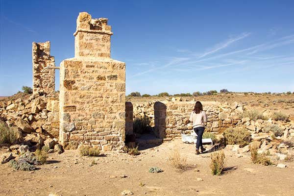
STRANGWAYS SPRINGS
Back on the road the next morning, the ruins at Strangways Springs provided a welcome opportunity to stretch our legs. This place is significant to the Arabana people and is known as Pangki Warrunha, meaning ‘White Ribs’, apparently in reference to the white banding on some of the mound springs here.
It’s also an interesting showcase of the impacts of European settlement and development in the area. In 1862 a pastoral lease was taken out on the land, which was then chosen as a repeater site for the Overland Telegraph Line in 1870. The Great Northern Railway was extended to the area in the 1880s, bringing with it workers and the subsequent development of a more substantial settlement. However, the completion of railway construction in 1891 and the transfer of telegraph services to nearby William Creek in 1896 saw the settlement decline.
We wandered the ruins, where three short walks take you on a meandering path among the mound springs, highlighting points of cultural, historical and natural interest. It was almost eerily quiet giving us a real sense of just how isolated this place must have been for those early European inhabitants.
KATI THANDA-LAKE EYRE
That sense of isolation persists for those who opt to take the 60km trek out to Halligan Bay on the salty shores of Kati Thanda-Lake Eyre and is particularly strong as you pass the roadside memorial to a tourist who died after becoming stranded here in 1998. The road is sandy and slow going, and those towing will need to consider the ability of their rigs before heading out.
As you near the lake, the arid brown-grey moonscape of ABC Bay greets you first, but continue on another 10 or so kays and you’re rewarded by the beautiful expanse that is Halligan Bay. Around 15m below sea level, Halligan Bay is the lowest point in Australia and an excellent place to view this usually dry national icon.
While tyre marks through the salt bed show it’s obviously a temptation for some, it’s illegal to drive on the lakebed, not to mention dangerous. And as you walk out across the crusted surface, the whistling wind your only companion, you quickly understand why. Aside from the obvious environmental impacts, the salt crust is incredibly thin in places with a sticky mud just below the surface that glues itself to your feet, sucking you down.
The national park campground offers basic facilities, along with the chance to sit and watch the sky and the seemingly endless expanse of salt morph through various shades of pink and purple as the sun sets. The quietness and stillness of this place holds a particular mystique – added to immeasurably by the haunting howls of dingos as the moon rose through the clouds.
OODNADATTA PINK ROADHOUSE
Oodnadatta’s Pink Roadhouse is every bit as pink as its name suggests, and it’s a sight most travellers welcome after a few days out in the dirt. We stopped to refuel and tuck into one of the renowned ‘Oodnaburgers’ at this outback institution.
The official naming of the Oodnadatta Track in 1979 is in many ways thanks to original roadhouse owners Adam and Lynnie Plate, who helped move the region on from its railway days and opened the area up to tourism. The roadhouse’s signature round signage – the work of the late Adam Plate – marks the sides of the Oodnadatta Track for hundreds of kilometres and while many are now faded beyond recognition, they still serve as a reminder you’re not totally alone out here. And these days, you really aren’t – during the peak tourist season you won’t go long without passing someone.
The tiny town of Oodnadatta sits at a junction and from here the Oodnadatta Track continues on the home stretch towards Marla and the sealed Stuart Highway. You can also take a side trip into the southern section of the Painted Desert, or you can opt, as we did, to leave the Oodnadatta Track behind for good and journey north on the exceptionally bumpy track through Witjira National Park to Mount Dare and the southern starting point of the Binns Track. Our Oodnadatta adventure might have ended here, but this track remains etched into memory as one of our Aussie touring highlights.
The full destination piece appears in Caravan World #569 2017. Subscribe today for the latest caravan reviews and news every month!


