
Kanku-Breakaways
The Kanku-Breakaways Conservation Park, in the heart of South Australia, is a unique and strikingly beautiful landscape of profound cultural significance to Aboriginal people as well as a major drawcard for the nearby opal mining town of Coober Pedy.
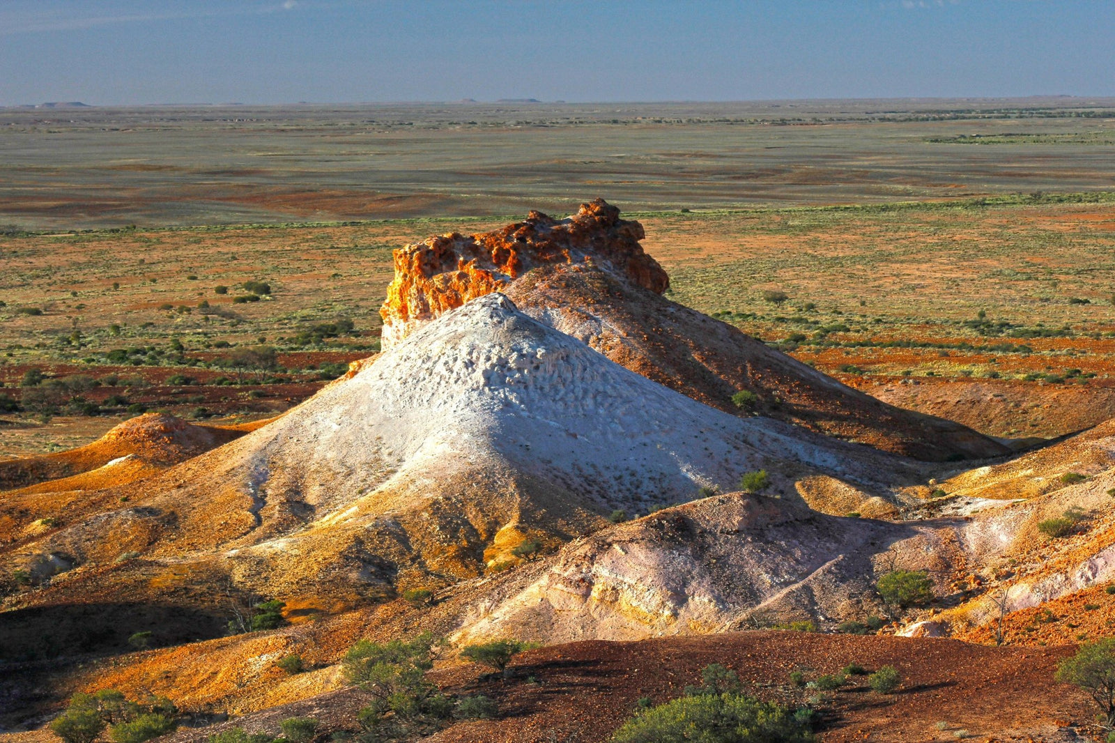
It embraces almost 15,000 hectares of majestic arid scenery — flat-topped mesas rising from a stony gibber desert, daubed in a palette of brilliant white, golden yellow, rosy pink and sunburnt ochre.
It is important in itself and as part of a network of reserves that are critical to the conservation of the SA outback.
NATURAL WONDERS
From a distance, this scattering of low hills appears to have ‘broken away’ from the higher escarpment of the nearby Stuart Range, earning them their common name of ‘The Breakaways’.
But appearances can be deceptive and this simple epithet gives little clue to the complex forces of nature that have created these geological marvels.
About 115 million years ago, the central plains of SA comprised the bed of a vast inland sea, a basin where mud and mineral-rich sediments collected and compacted under their own weight, layer upon layer until they formed a deep plate of rock. The sea receded, exposing the plain to solar radiation and searing temperatures that evaporated all moisture from it and baked a durable crust of silcrete (sand and gravel cemented by dissolved silicon) to its surface. Tectonic forces stretched the crust and buckled it causing cracks and fissures that were widened and deepened by wind and water.
Millions of years of weathering and erosion ate away the soft sedimentary substrate, leaving a flat cap of silcrete flanked by steep, multi-hued escarpments crumbling down to gibber-covered foothills and floodplains. These gibbers are the discarded fragments of the once-impervious silicon crust that eventually succumbed to the irresistible elements.
These erosive forces continue to work on the ancient landforms in a climate that is arguably the hottest and driest of any region on the continent, where summer temperatures can rise to 50C (65C on the ground) and the parched landscape receives a miserly annual rainfall of less than 170mm. (Ironically, ‘Breakaway Country’ covers part of the Great Artesian Basin, a seemingly inexhaustible supply of subterranean water.)
Surprisingly, this harsh desert environment supports more than 60 native plant species (two of them rare) in a variety of habitats, such as acacia-lined watercourses, scree slopes dominated by mulga, and open shrublands of cassia and eremophila — all perfectly adapted in their own way to conserving moisture and surviving the intense heat.
Some species, such as acacias, have thin spiky leaves to minimise transpiration; saltbush, daisy bush and other succulents greedily suck moisture from the soil when rain falls and store it in their fleshy leaves; others, such as pussy tails and fox tails, have a felt or fine powdery coating on their leaves to baffle the drying wind, leaving a humid layer of air around the leaf’s surface.
Because rainfall is unpredictable and sporadic, seeds germinate only when there is enough moisture to ensure the plant can grow to maturity, then they emerge and flourish. In this way, flowering annuals sprout after good rain to provide spectacular displays of colour.
This arid, sparsely vegetated landscape is also home to a surprising abundance of native animals and birds across about 60 species. Visitors are most likely to encounter red and grey kangaroos, euros and dingoes around dawn and dusk, and reptiles such as bearded dragons, goannas and snakes during all but the hottest daylight hours.
The Perentie, Australia's largest monitor (and also the second largest lizard in the world after the Komodo Dragon), is a wide-ranging predator across the rocky outcrops and gullies.
Flocks of galahs, corellas and budgerigars add a colourful, and sometimes noisy, dimension to this stark desert tableau; birds of prey are ever-present — kites, hawks and kestrels hunt the plains and mesa by day and magnificent wedge-tailed eagles spot their prey while soaring on thermal airstreams.
When the sun has set and the twilight fades to cooler darkness, owls glide silently through the shadowy landscape seeking native mice and dunnarts, while bats take insects on the wing.
INDIGENOUS CONNECTIONS
The Breakaways are within the traditional lands of the Antakirinja Matu-Yankunytjatjara Aboriginal people who lived in this region for thousands of years before European settlement. In their language the area around present-day Coober Pedy is called ‘Umoona’, meaning long life, referring to a particular kind of tree that grows here among the hills.
The first European to pass through the area was explorer John McDouall Stuart in 1858. After teenager Willie Hutchinson discovered opal in 1915, and miners came in droves to claw it from the stony earth, Aboriginal people named the town site ‘Kupaku Piti’, meaning white man's hole.
By 2000, there were more than 250,000 mine shaft entrances in the area, and still counting.
The Antakirinja Matu-Yankunytjatjara people have a deep spiritual connection to their Country, which is embedded in the landforms and natural environment. Many features are the subject of Dreaming stories that weave their way across the landscape for thousands of kilometres, transcending state borders.
The Breakaways comprise a traditional teaching place for young men and Antakirinja Matu-Yankunytjatjara culture does not permit full details of the stories to be shared beyond gender restrictions or with people other than certain elders within their community. However, some information has been shared with the public that helps us to understand the Aboriginal perspective of the Breakaways and provides a ‘preview’ of the Creation story behind the landforms.
For example, one of the most distinctive formations is a pair of hills, one chalky white and the other tawny gold, commonly referred to by non-Indigenous people as ‘Salt and Pepper’ or ‘The Castle’. Though close together and joined by a low saddle, the stark difference in colouring has been caused by a variation in weathering, the white hill having eroded faster than the brown one to reveal a different layer of colourful oxides in the rock.
Whatever the cause, the Aboriginal name for the site is ‘Papa Kutjara’, or two dogs sitting down. The peaked hill nearby is ‘Wati’ (Man) who is the owner of the dogs. Beyond Two Dogs is ‘Kalaya’, a cluster of hills presided over by Father Emu, who is looking after his little chicks. This is a very important place and Emu is revered as the one-time guardian of the whole area. From Lookout Two you can see the prominent formations known as Willy Wagtail, in the foreground, and Bearded Dragon Lizard, which is a totem for the Antakirinja people.
There is also much evidence of past Aboriginal occupation in the Breakaways, in the form of quarrying and tool-making sites, and stone tools that show a high level of workmanship. Many artefact scatters are closely linked with ritual and ceremonial sites, and the hills are an important source of multi-coloured ochres used in body decoration for ceremonies.
To protect these sites and features, the entire park is a registered Aboriginal Site under state legislation. Also, in 2011, the Federal Court granted a native title claim by the Antakirinja Matu-Yankunytjatjara people to an area of 78,672 square kilometres around Coober Pedy. The determination confers non-exclusive rights to hunt, fish, live, camp, gather and use natural resources, undertake cultural activities including relating to births and deaths, conduct ceremonies and meetings, and protect places of cultural and religious significance.
Since 2013, the conservation park has been managed under a unique co-management agreement between the Department of Environment, Water, and Natural Resources in conjunction with the Antakirinja Matu-Yankunytjatjara Aboriginal Corporation and the District Council of Coober Pedy; ‘Kanku’ (pronounced ‘kah-ngoo’), meaning shelter, was added to the park’s name to signify the importance of the place for the Aboriginal community and to recognise the ongoing Indigenous relationship with the land.
TAKE A BREAK(AWAY)
Despite its remote location and forbidding desert environment, The Breakaways are easy to find and easy to get around. The park lies 25km north of Coober Pedy via the Stuart Highway, and is accessed from the west by a 5km dirt road from the highway to the main lookouts perched on the rim of a crumbling escarpment with expansive views of the beautiful formations rising from the surrounding plains.
The alternative, and by far the more interesting, route is to approach the Breakaways from the southeast. From Coober Pedy, follow Kempe Road east towards Oodnadatta on a firm gravel track.
On the outskirts of town, travellers are confronted by a road sign that blares in large red letters, “Remote Areas Ahead” and, cresting a low rise beyond it, Moon Plain stretches away to the horizon in every direction.
This vast, flat expanse is aptly named for its likeness to a lunar landscape — a red gibber desert, seemingly devoid of all life — and a very daunting sight indeed. From this ancient Eromanga seabed have been recovered the opalised fossil remains of numerous cretaceous marine creatures, such as 5m dolphin-like ichthyosaurs, plesiosaurs, fish and sharks. So unusual is the modern-day landscape that several filmmakers have considered it the perfect setting for movies including Mad Max Beyond the Thunderdome, Priscilla Queen of the Desert, Pitch Black, The Osiris Child and The Red Planet (about Mars, not the moon).
After about 15km, Kempe Road intersects the Dog Fence — the world’s longest fence. It was built during the 1880s as a barrier to dingoes, in order to protect sheep flocks in the fertile pastures of the continent’s south-east, where the native dogs had largely been exterminated. (One station alone lost more than 11,000 sheep in a year due to dingo attacks before the completion of the fence.)
One of the longest structures in the world, the fence stretches 5614km from Jimbour on Queensland’s Darling Downs through the arid inland to the Great Australian Bight near Nundroo, west of Ceduna. Although the fence has helped reduce sheep losses to these native predators, its effectiveness has been reduced through damage caused by feral camels and increased pasture competition from rabbits and kangaroos, leading to lower stocking rates.
Turning northwest at the fence, there is a minor dirt road that winds its way into the conservation park for about 14km to the lookouts. With every passing kilometre, the formations loom ever larger and more colourful, passing Papa Kutjara, Wati and Kalaya before climbing the plateau, from which the beautiful Breakaways are spread out below.
As impressive as they are when viewed at close range on ground level, this elevated perspective affords visitors a stunning panorama of these ancient marvels, especially late in the day when the colours change with the setting sun.
There is no camping or accommodation available within the park but Coober Pedy offers several options. Mountain biking is currently not permitted, and there are no bushwalking trails other than some informal tracks around (but not over) the formations and between the lookouts.
But just the sight of the amazing Kanku-Breakaways is reward enough for a visit — a truly quintessential outback experience embracing a strikingly beautiful landscape rich in Indigenous heritage.


