
The Great Green Way: Townsville and Cairns, Qld
The Great Green Way is the 345km stretch of the Bruce Highway (A1) that connects Townsville and Cairns. It is aptly named for passing through Queensland’s Wet Tropics World Heritage Area, a region of breath-taking tropical beauty with the closest mainland access to the Great Barrier Reef. The scenic drive can be completed in five hours non-stop but it’s better to take a few days (or weeks) to experience bushwalking in rainforested mountains, white-water rafting on untamed rivers, strolling along palm-fringed beaches, snorkelling on coral reefs, and the friendly, relaxed lifestyle of North Queensland sugar towns. Don’t rush it, just sit back and enjoy this amazing journey.
THE WET TROPICS OF QUEENSLAND
The ‘Wet Tropics’ embraces almost 9000sqkm of North Queensland’s coastal ranges. As its name suggests, the region receives an enormous amount of rain, averaging as much as 8000mm annually. In 1988, it was inscribed on the UNESCO World Heritage list for its exceptional natural beauty and as a living record of the evolution of land plants over more than 200 million years.
It is a stunningly beautiful tropical landscape: rugged mountain peaks blanketed by dense rainforests; wild rivers coursing through deep gorges; towering waterfalls (including Wallaman Falls, Australia tallest at 268m); forested lowlands crowding sweeping sandy beaches; and mangrove forests close to fringing coral reefs. Although comprising a tiny fraction of Australia’s land mass, the Wet Tropics conserves an astonishingly rich diversity of plants and animals.
The region also has great cultural significance for Indigenous people. About 18 Aboriginal groups occupied these ranges for at least 20,000 years, developing a unique and specialised culture that enabled them to live year-round in the tropical rainforest environment — the only place in Australia where Indigenous people are known to have done so.
TOWNSVILLE (1350KM NORTH OF BRISBANE)
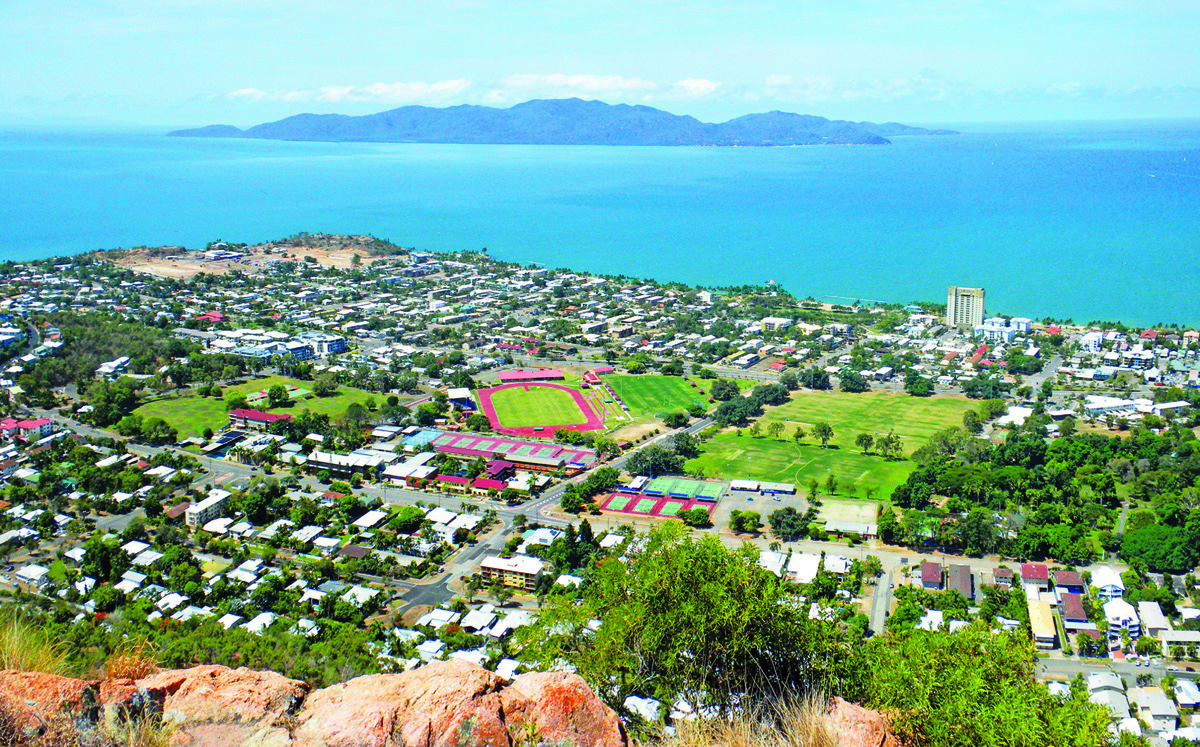
Townsville is the de facto ‘Capital of North Queensland’. From humble origins as a frontier port on Cumberland Bay, it has grown into a vibrant modern city of just over 194,000 residents, and is the commercial, industrial, and cultural hub of one of Australia’s most productive regions.
Despite its industrial and commercial trappings, Townsville is a city of great charm and style with a relaxed vibe that resonates in its elegant heritage-listed buildings, verdant botanical gardens, and close proximity to Magnetic Island. The inner city stretches along The Strand, a 2km beach and parkland strip fronting Cleveland Bay, and is overlooked by the red granite monolith of Castle Hill (286m). The historic heart of the city is the waterfront precinct of Flinders Street East, overlooking Ross Creek, where gracious two-storey buildings bear witness to the town’s evolution from a provincial outpost to a pre-eminent regional capital.
Unusually for Far North Queensland, the city lies in a rain shadow known as the ‘Dry Tropics’, created by the east-west orientation of the local coastline, which alters the effect of the prevailing south-east trade winds. With a climate that is more savannah-like than ‘wet tropical’, Townsville enjoys winter months with less rainfall and more sunshine, ideal for a mid-year vacation.
PALUMA RANGE NATIONAL PARK
Fifty kilometres north of Townsville, the Bruce Highway encounters the Paluma Range National Park (17,310ha), well signposted and easily accessible from the highway. The southern section encompasses much of the escarpment and its two highest peaks, Mt Halifax and Mt Spec, that loom more than 1000m above the coastal plain. Near Mt Spec, Big Crystal Creek is a popular swimming venue and camping area suitable for small caravans, camper trailers and campervans. In the northern section of the park, Waterview Creek tumbles down the range’s foothills, creating picturesque Jourama Falls and rocky cascades along the way. An unsealed road from the highway crosses two causeways to the Jourama Falls camping area, which may be inaccessible during the summer wet season. Set in a grassy clearing amid lush forest beside the creek, this is a popular retreat for larger caravans and motor homes, with facilities that include composting toilets, showers, water (treat before drinking), gas barbecues and picnic tables.
INGHAM (110KM NORTH OF TOWNSVILLE)
Established in the 1870s, Ingham straddles Palm Creek, near its confluence with the Herbert River, 25km from the coast. The town is surrounded by a patchwork of sugar plantations, which flourish on the fertile floodplains, and the two local mills crush more than 5.5 million tonnes of sugar in a season (June–November). Once processed, the raw sugar is transported by tramline to the bulk terminal at the nearby port of Lucinda and loaded onto ships for export. The town is known as ‘Little Italy’ because more than half its population is descended from Italian immigrants who took up farming allotments between 1890 and 1920. This cultural heritage is celebrated at the Australian-Italian Festival held in August each year and is one of the region’s most popular events. Another major attraction is the impressive Tyto Wetlands Centre, a multipurpose precinct that incorporates a regional art gallery, a small military museum and a 110ha wetlands park boasting 240 species of birds.
LUCINDA (25KM EAST OF INGHAM)
The sleepy seaside hamlet of Lucinda lies at the southern entrance to Hinchinbrook Channel, only 7km from George Point on the world heritage-listed island. The town’s main attraction is the remarkable bulk-loading sugar facility, which features a 5.76km jetty, reputedly the world’s longest. Lucinda is also renowned as an angler’s paradise, with the Channel to the north and the Coral Sea to the east offering plentiful mangrove jack, barramundi, mackerel, trevally, queenfish, bluefin tuna and black marlin. The nearby settlement of Dungeness, on the banks of the Herbert River, is a fishing base equipped with a launching ramp, public pontoon, moorings, and accommodation. From here, commercial ferries and private charter boats convey adventurers to the southern end of the Thorsborne Trail on Hinchinbrook Island, rated as one of the world’s top 10 walks.
CARDWELL (50KM NORTH OF INGHAM)
At Cardwell, the Bruce Highway forms the town’s main street, with cafes, hotels and seafood outlets on the western side and a picturesque foreshore parkland fronting a golden beach to the east. This pleasant holiday town occupies a narrow coastal strip between the rugged Cardwell Range and the Hinchinbrook Channel. The range’s cloud-shrouded ridges are protected by the Girringun National Park, which slopes through luxuriant rainforest to the Cardwell State Forest behind the town. A 26km scenic drive traces a loop through a mix of native vegetation and pine plantations, connecting Cardwell Lookout and picnic areas beside swimming holes at Attie Creek Falls, Dead Horse Creek, and Spa Pool. Hinchinbrook Island is accessed by ferry or private charter, which deposit day-trippers at the northwest tip and hikers at Ramsay Bay on the north-east end of the Thorsborne Trail.
TULLY (43KM NORTH OF CARDWELL)
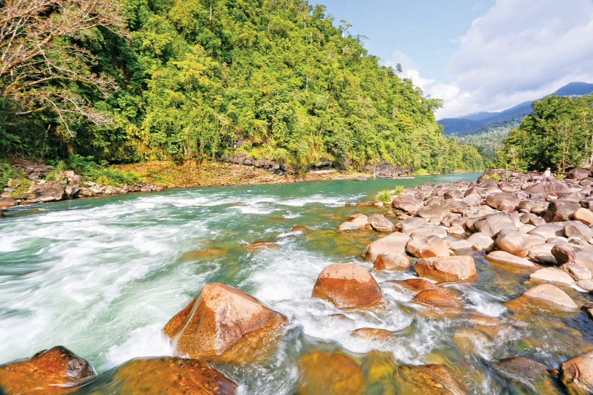
The lush green town of Tully vies with nearby Babinda for the title of the wettest town in Australia, with Tully notching an Australian record of 7900mm in 1950. In celebration of this dubious honour, the ‘Golden Gumboot’ was erected at the entrance to Tully’s main street. Standing 7.9m high (corresponding to the record), this whimsical edifice is adorned with an oversize fibreglass green tree frog and is the focus of the town’s annual Golden Gumboot Festival. The abundant rainfall nurtures more than 22,000ha of local sugar plantations, which deliver about 2 million tonnes of cane to the Tully Sugar Mill for crushing every year. As well, 5000ha are devoted to banana production, which makes a significant contribution to the local economy. The town sits at the edge of the Tully Gorge National Park, 60,000ha of rugged rainforested ranges that protect the headwaters of the Tully River and two of its highest peaks, Mt Tyson (640m) and Scout Rock (570m), which stand impressively just west of the town. The Tully Gorge camping area, 41km north-west of Tully, is a grassy clearing beside the river, with ample room for caravans, camper trailers and motorhomes, and is a popular venue for white-water rafting and kayaking.
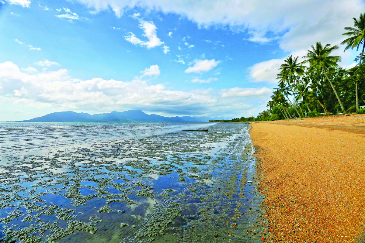
MISSION BEACH (28KM EAST OF TULLY)
Mission Beach is not so much a single town as a series of delightful, interconnected villages — South Mission Beach, Wongaling Beach, Mission Beach and Bingil Bay — reclining on a long golden beach beside the sparkling Coral Sea. The town centre is accessed from the Bruce Highway by a 20km scenic drive through lush tropical rainforest inhabited by large numbers of southern cassowary, one of the world’s largest flightless birds. Lying just 4km offshore, Dunk is the largest of the Family Islands within the Great Barrier Reef, with fringing reefs that are home to turtles, dugongs, corals, and brightly-coloured fish. National park covers most of the island and is accessible by ferry or water taxi for a range of recreational activities, such as bushwalking, beachcombing, swimming, snorkelling and camping. Since the 1980s, tourism has transformed these sleepy beachfront villages into a thriving holiday destination, with an excellent array of accommodation and an eclectic mix of sophisticated eateries, thatch-roofed bars, boutique shops, art galleries and roadside markets.
INNISFAIL (50KM NORTH OF MISSION BEACH)
At the town of Silkwood, 20km north of Mission Beach, The Canecutter Way detours west from the highway on a scenic drive through the hinterland. It is named in honour of the original sugar growers and their teams of cane cutters, who pioneered the industry that now flourishes on these red soil plains. Along the Way, Mena Creek is home to Paronella Park, a 5ha environmental park designed and built by Spanish immigrant Jose Paronella in the early 1930s as a Moorish-inspired ‘pleasure garden’. The heritage-listed park is one of the district’s major attractions and is well worth a visit.
Innisfail straddles the confluence of the North and South Johnstone Rivers, surrounded by agricultural holdings largely devoted to the production of sugar and bananas, as well as a variety of tropical fruit and vegetables. It is the home port of a large commercial fishing fleet and the centre of an emerging aquaculture industry in barramundi, prawns, and crayfish. The town centre is dotted with many impressive art deco buildings, the legacy of a rebuilding program that followed a devastating cyclone in 1918.
CAIRNS (90KM NORTH OF INNISFAIL)
North of Innisfail, the highway hugs the eastern flanks of the mountainous Wooroonooran National Park, one of the most scenic parts of the Wet Tropics. Blanketed by lush rainforest that captures some of the highest rainfall in Australia, the park encompasses 80,000ha of the Bellenden Ker Range, featuring Queensland’s highest peak, Bartle Frere (1622m) and the spectacular Josephine Falls.
Cairns and its satellite suburbs spread along a narrow coastal strip on the western shore of Trinity Bay, bounded in the north by the Barron River and, in the south, by Smiths Creek. The creek and its tributaries drain a vast mangrove wetland that provides habitats for estuarine wildlife and nurseries for fish and prawns of economic significance. After settlement in the 1870s, the town initially served miners heading for the Hodgkinson River goldfield, and later developed into a railhead and major port for exporting gold and agricultural products from surrounding districts and the Atherton Tableland. During World War II, ‘Fortress Cairns’ was a major base for Allied operations in the South-west Pacific.
Since the 1960s, a maritime precinct has developed along the north bank of Smiths Creek, with the Marlin Marina accommodating yachts and charter operators, Trinity Wharf providing port services for freighters and cruise liners, the RAN patrol boat base at HMAS Cairns, and one of Australia’s largest commercial fishing fleets. Cairns is now the major commercial centre and transport hub for Far North Queensland and Cape York Peninsula. It is an aggressively modern city with a cosmopolitan vibe, driven by tourism which booms in the balmy dry season (June–October), with cruises to the Great Barrier Reef for snorkelling and deep-sea fishing, Skyrail forays to charming tableland villages and 4WD adventures to Cape York.
CONTACTS
TOWNSVILLE CITY VISITOR INFORMATION CENTRE
- 340 Flinders Street, Townsville
- P: (08) 4721 3660 or 1800 801 902
- E: hello@townsvillenorthqueensland.com.au
- W: townsvillenorthqueensland.com.au
HINCHINBROOK VISITOR INFORMATION CENTRE
- Cnr Cooper Street & Bruce Highway, Ingham
- P: (07) 4776 4790
- E: tourism@hinchinbrook.qld.gov.au
- W: hinchinbrookway.com.au
CARDWELL RAINFOREST AND REEF VISITOR INFORMATION CENTRE
- 142 Victoria Street, Cardwell
- P: (07) 4066 8601
- E: info@greatgreenwaytourism.com
- W: greatgreenwaytourism.com.au
TULLY VISITOR AND HERITAGE CENTRE
- Bruce Highway, Tully
- P: (07) 4068 2288
- E: tullytourism@ccrc.qld.gov.au
- W: tropicalcoasttourism.com.au
MISSION BEACH VISITOR INFORMATION CENTRE
- 55 Porter Promenade, Mission Beach
- P: (07) 4068 7099
- E: info@missionbeachtourism.com
- W: missionbeachtourism.com
INNISFAIL VISITOR INFORMATION CENTRE
- 1 Eslick Street, Innisfail
- P: (07) 4067 2655 or 0428 228 962
- E: innisfailtourism@ccrc.qld.gov.au
- W: tropicalcoasttourism.com.au/around-innisfail
CAIRNS TOURIST INFORMATION CENTRE
- Shop 6. Cnr Aplin Street & The Esplanade, Cairns
- P: (07) 4047 9125
- E: info@ cairnstouristinformation.com.au
- W: cairnstouristinformation.com.au
QUEENSLAND NATIONAL PARKS
- P: 13 74 68
- W: parks.des.qld.gov.au/camping
- W: parks.des.qld.gov.au/parks


