
Southern Inland Parks, Qld
Heralded by a flurry of wet weather, spring finally arrived in southern Queensland and with it the urge to dust-off Tikay (our Kimberley Karavan) and hit the road. After lengthy consultation with an RACQ road map and a brand-new Camps 8 guide, we plotted a southward course along the Country Way with a plan to visit a brace of national parks in the South Burnett, the Darling Downs and the Granite Belt.
The weather gods were smiling as we left our home in Hervey Bay and crossed the Coast Range on winding country roads through wooded vales and sprawling cattle pastures. At the sleepy township of Kilkivan, we paused for morning tea under blossom trees at Lion’s Park off the main street (Wide Bay Highway). Across the road, an equestrian statue on the front lawn of the community hall bears witness to the town’s historical links to the Bicentennial National Trail (BNT), which traces 5330km of old stock routes along the Great Dividing Range from Healesville, Vic, to Cooktown, FNQ. Commemorating its pioneering heritage in March each year, the Kilkivan Great Horse Ride attracts over 1000 mounted riders along part of the trail for a grand parade down the main street.
BENARKIN STATE FOREST
The BNT also connects with the town of Blackbutt further south, which we reached in quick time along the Country Way (aka New England Highway). Together with Yarraman and Benarkin, Blackbutt forms a trio of ‘timber towns’ in the South Burnett, whose origins lie in the timber industry of the late 19th century. (Indeed, ‘blackbutt’ is the common name for Eucalyptus pilularis, one of Australia’s most important hardwoods.) After sawmilling cleared the surrounding range of one of the finest stands of ironbark in Queensland, agriculture and silviculture took over as the region’s economic mainstay. After the 1920s, hoop pine plantations sprang up in the district and Benarkin State Forest, 3.5km east of Blackbutt on the D’Aguilar Highway, was the first on our list of reserves to explore.
From the highway, a steep and winding gravel road provided a 16km scenic drive down the Blackbutt Range through a patchwork of majestic hoop pines, towering eucalypts and dense vine scrub to camping and day-use areas along Emu Creek, a tributary of the Brisbane River. Benarkin State Forest is a multiple-use reserve. It not only produces timber resources and protects habitats for a rich variety of plants and animals, but also provides a host of recreational opportunities for visitors. Logging and service tracks crisscross the forest and can be used for four-wheel-driving and trail bike riding, walking, cycling or horse riding. A section of the 148km Brisbane Valley Rail Trail passes through Benarkin State Forest, following the disused rail line up the Blackbutt Range to Yarraman. The route is used by walkers, touring cyclists and horse riders for day tripping, overnight camping or longer-term adventures.
CROWS NEST NATIONAL PARK
Regaining the New England Highway at Yarraman will take you south via Cooyar to Crows Nest, but we opted for the roads less travelled from Blackbutt through the Googa State Forest and the localities of Mount Binga and Pierces Creek to Crows Nest and the national park 6km east of that town. The camping area here is only small with about 12 generous-sized sites, each with a fireplace, set around the perimeter of a grassy common. Some of the sites were occupied by motorhomes, tents or caravans and we settled into our space with the lowering sun casting long shadows through the many trees in and around the camp. The facilities included hot showers, if you brought your own firewood to stoke the boiler of the ‘donkey’ to heat the water – an innovation we have not seen in any other national park across the country.
As dusk fell, so did the thermometer – a lot! Our research about the park did not reveal any mention of its altitude (about 550m ASL) nor did we count on a strong high-pressure system sucking cold air up from the southern states, both of which combined to produce very chilly conditions. The absence of a second woolly blanket ensured that we spent an uncomfortably cold night in Tikay, an experience we avoided on subsequent nights by sleeping near-fully clothed, including my best Donegal hiking socks.
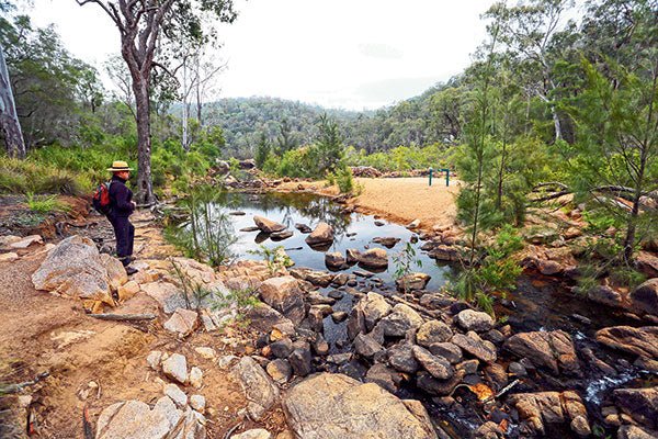
We were woken next morning around 5am by the ‘bush alarm clocks’ (aka kookaburras), their manic laughter signifying some demonic pleasure in getting the rest of the world out of bed at such an ungodly hour. It was a cool day and somewhat overcast, good weather for hiking, so we set off promptly to explore the local walking trail – a fairly easy 4.5km loop that followed Crows Nest Creek, first to The Cascades and Kauyoo Pool with some striking rock formations, Bottlebrush Pool with more rocky features around a tranquil swimming hole and on to Crows Nest Falls Lookout. After the recent rains, a goodly stream was tumbling through the boulder-strewn gorge, before plunging 20m over the falls into a waterhole surrounded by steep, granite cliffs. Another track continued through bushland to Koonin Lookout overlooking the Valley of Diamonds, whose name refers not to mineral wealth but rather to the spectacular view of the gorge and the distant hills around Ravensbourne.
RAVENSBOURNE NATIONAL PARK
Continuing our southbound progress next morning, we covered only 20km before diverting into Ravensbourne NP to indulge in some more bushwalking. Declared in 1922, this 687ha park conserves a small remnant of the vast forests that once covered the slopes and crest of the Great Dividing Range – blackbutts, bloodwoods and Sydney blue gums, towering over dense groves of piccabeen palms and cool, dark rainforest where jewelled fungi, ferns and elkhorns thrive. More than 100 species of birds inhabit this forest and their myriad calls are a walker’s constant companion. For thousands of years, Jawowair and Jagera Aboriginal people occupied the range, harvesting the forests’ bounty and ushering other tribes on their way to bunya nut festivals in the nearby Bunya Mountains.
Today, visitors can’t camp here but it’s an ideal place for the family to enjoy a picnic at the shady Blackbean day-use area (named after the giant trees that once again flourish here) and experience the forest’s beauty and birdlife along several easy walking trails. A short drive from the Blackbean carpark, the Cedar Block picnic area occupies a grassy knoll with panoramic views from the Gus Beutel Lookout towards Brisbane, the Scenic Rim and the Lockyer Valley. A short self-guided walk through the adjacent forest, with interpretative signs, informs visitors of the area’s Aboriginal heritage and the history of the European timber-getters.
From Ravensbourne, the unsealed 17 Mile Road beckons travellers down a forested ridge to Helidon, Grantham and more parks in the Darling Downs.
Visitors can stay overnight at nearby Crows Nest NNP, Cressbrook Dam or in holiday accommodation in and around Ravensbourne, Hampton, Crows Nest, Toowoomba or Esk.
Getting there
- Benarkin is about 150km north-west of Brisbane via the D’Aguilar Highway. At the Benarkin day-use area 3.5km east of Blackbutt, turn off the D’Aguilar Highway and take the gravel road 16km to camping and day-use areas beside Emu Creek.
- Crows Nest NP is about 160km west of Brisbane via the Brisbane Valley Highway (A17) and Esk. Turn off the New England Highway at Crows Nest and take the sealed road 6km to the park.
- Ravensbourne is located bout 130km west of Brisbane via Ipswich and Esk. The park turn off is 33km west of Esk via the Esk-Hampton Road.
Activities
- Benarkin: Scenic forest drive in the Blackbutt Range, fishing in Emu Creek, horse riding, four-wheel-driving and trail bike riding
- Crows New: Crows Nest Creek, spectacular granite outcrops, scenic waterfall, wildlife and bushwalking
- Ravensbourne: Towering gums, palm groves, relict rainforest, birdwatching, bushwalking, panoramic views from Gus Beutel Lookout
The full feature appeared in Caravan World #559. Subscribe today for the latest caravan reviews and news every month!


