
Mt Mulligan, Qld
Across the wilderness that stretched inland from Cairns across the base of Cape York, rich goldfields sprang up during the 1870s, operating right through to the early 1900s. Some, like the Hodgkinson field, were so rich they set in motion great changes that helped shape the development and history of northern Queensland. Other minerals were found in the wake of these gold discoveries and towns sprang up quickly, only to wither and die when the mines were exhausted. But even today, rich mineral finds are being discovered and dug from the earth.
The route we took through this region winds through rugged mountain ranges covered in dry eucalypt forests inland from Cairns and north of the farming community of Dimbulah. For locals, it’s a nice two-to-three day jaunt away from the bright lights of the coast, while for visitors heading further north, it’s a great connecting route from Chillagoe or Mt Surprise to the major routes of Cape York. For history buffs, it’s a ‘must do’, while steam engine lovers will be amazed at the workings of the only operational historic 10-head gold stamper in Australia.
DAYS GONE BY
Fresh from his discovery of the mighty Palmer River goldfields in 1873 but broke after blowing the government’s thousand-pound reward, James Venture Mulligan, the doyen of our northern pioneer gold prospectors, set out from Cooktown in August 1875 to try his luck once more.
After wandering the wilds for months, he struck gold in January 1876 on the headwaters of the Hodgkinson River and a rush quickly set in. Sadly for the miners of the day, the Hodgkinson was not an alluvial field like the Palmer River, but one that demanded heavy machinery to work effectively.
Still, before too long, there were a few thousand people on the field (some have said 10,000 but, in reality, it never got over 3000) and more than 300 mines. Thornborough was the capital and, at its peak in the 1880s, it had a courthouse, police station, 22 hotels, two hospitals, many churches and even a School of the Arts.
Cairns was established to service this great new find and, for a few years, the new port prospered, only to be usurped by Port Douglas when explorer Christy Palmerston found an easier route through the ranges to the Hodgkinson field.
THE ROAD NORTH
Today, a good dirt road strikes north from Dimbulah, leaving the verdant irrigated fields quickly behind and then winding through low rugged hills for about 30km to a well-sign-posted junction just short of the main Thornborough township. Veering right here takes you through the old townsite where, apart from a couple who call the place home, only a few scattered remnants remain of the once-vibrant town.
The Thornborough cemetery, which is nearby and is maintained annually by the Cairns 4WD Club, is a poignant place – one family lost five kids in just 11 years. It is more easily visited when you return to the aforementioned junction and veer left to continue this drive north to Mt Mulligan.
From the scattered ruins of the Thornborough townsite, the road continues on to the Tyrconnell mine and the nearby ruins of Kingsborough.
The township of Kingsborough, which was just over the ridge from the Tyrconnell mine, once had a population of around 1000 hardy souls along with 12 hotels –they were obviously a thirsty lot! This town serviced not only the Tyrconnell mine but also the General Grant mine – the two richest goldmines in the field which produced something like 3.7t of gold (120,000 ounces) between them, out of the field’s total of 9.7t.
Tyrconnell was the longest-lived mine on the field and was worked continuously up until 1942. In the 1980s, the lease was taken over by Andrew Bell’s family who worked it for a number of years. Andrew and his wife, Cate, now run the mine as a tourist destination and it boasts the only working 10-head gold stamper in Australia. One of the dozen stampers that once dotted the field, Andrew will fire it up for group tours and, as the behemoth roars, rattles and thumps into life, with its big leather belts whipping around like streamers in the breeze and raw ore clatters and clangs in the feeder chutes in a cacophony of noise, you’ll wonder how anybody could live and work – and survive – in amongst it all. It’s a beauty!
The Kingsborough township is all but deserted today except for Ike, a Swiss traveller and prospector who settled here on a vacant block back in the 1970s. He has built everything you can see, including the weirs along the ephemeral Caledonia Creek that give his gardens water and have turned his little patch into a verdant oasis. You can camp here and, on our last trip through the region, we set up camp in his garden.
After you have finished exploring around here, you need to backtrack 7km or so to the junction near Thornborough and then head north. From here, the route continues, first passing the Thornborough cemetery before running parallel to the increasingly impressive 400m high, 18km long bluff of Mt Mulligan, which dominates the western skyline.
MT MULLIGAN
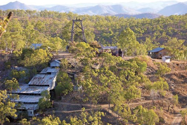
About 20km north of the Thornborough junction, you come to Mt Mulligan Homestead just off to the left. The main building was once the hospital of the Mt Mulligan township. A few hundred metres past the homestead, you come to the heart of the old mining area and the monument to the disaster which befell this once big and important coal mine.
Coal was discovered here in 1907 and, by 1915, the mine was supplying coal to the furnaces of the impressive smelters at Chillagoe, 95km further west of Dimbulah. In September 1921, a huge explosion wracked the Mt Mulligan mine, killing all 74 workers who were underground at the time and making it the third worse mining disaster in Australian history. The mine, however, was re-opened a couple of years later and kept operating until 1957 when it was abandoned. In recent times, a lot of signage has been erected around the mine site and adjoining townsite, which makes exploring the immediate area much easier and more enjoyable. There is a surprising amount of ruins and old infrastructure remaining.
The town cemetery, 1km north of the homestead and beside the main road, is another distressing place where fathers lie beside sons and brothers beside brothers, and where 54 younger kids were made orphans on that terrible day – the day they say even the devil wept!
Apart from the decaying reminders of the days of coal, there’s a fabulous little camping area beside a small tree-lined lake. With its backdrop of Mt Mulligan and its rich birdlife, it’s a top spot to spend a day or so and, after you’ve finished exploring, you can always go fossicking for gold.
The route north from Mt Mulligan becomes less well-maintained but is still pretty good and easily good enough for an offroad caravan, although longer rigs in excess of 6m may have some difficulty with the creek crossings. The route crosses a number of streams and parallels the Hodgkinson River for much of the way, but most of these streams are bone dry apart from during or just after the wet season.
Along the Hodgkinson River, smaller towns and settlements sprang up during the heady days of the gold rush. These included Woodville, Stuarts Town, Union Mill and Wellesley but, today, little remains of the ephemeral settlements that sprang up near mines or crushers and just as quickly died as the gold ran out.
Kondarparinga Station, the next property north, is Aboriginal-owned and you are not allowed to camp or leave the public thoroughfare. Still, you’ll get some impressive views of the Mt Mulligan escarpment, the northernmost bluff being very impressive and worthy of a stop. After passing close to the homestead (28km from Mt Mulligan), the route quickly leaves Kondarparinga as the route then passes through the Australian Wildlife Conservancy’s Brooklyn Sanctuary.
The road, which improves after the homestead, borders the mighty Mitchell River but it is mainly out of sight until you cross it on a concrete ford, 20km from Kondarparinga homestead. There’s always water flowing across here but, during the Dry, it is rarely deep enough to stop traffic, while close to the ford there are a couple of nice camp spots, but these can be very popular.
Less than 10km later, you meet the blacktop about 17km west of at Mt Carbine. Here, you can turn east for Mt Carbine, Atherton and Cairns, or north to Cooktown and The Top. You may be a little dustier for your troubles, but the journey along the edge of the great escarpment of Mt Mulligan is one you won’t forget in a long time!
FAST FACTS
Getting there
- Dimbulah is 110km south-west of Cairns and 47km south-west of Mareeba on the Burke Development Road, while Mt Carbine is 70km north of Mareeba.
Activities
- Tyrconnell mine and gold stamper.
- Kinsborough township: all but deserted except for one man’s creations.
- Mt Mulligan: visit the monument to the third worst mining disaster in Australia’s history, do some bird-watching or fossick for gold.
More information
- The Tyrconnell Mine offers camping and accommodation and meals along with some really interesting tours.
- Camping at Ike’s place in Kingsborough is pretty informal. Rock up, pay your money and set
- up camp.
- The camping at Mt Mulligan is a bit up in the air at present, but a bush camping area is located just south of the old homestead, where you roll up and pay your money, before setting up camp. Bush camping is also possible along the route north of Mt Mulligan, the most popular being near the crossing of the Mitchell River, 10km from the main Peninsula Developmental Road.
The full feature appeared in Caravan World #521. Subscribe today for the latest caravan reviews and news every month!


