
Bunya Mountains, Qld
One of the best scenic drives in south-east Queensland is the Great Bunya Drive between Gympie and Toowoomba. As it meanders 390km among the red-soil farmlands and lush grazing pastures of the South Burnett and Darling Downs, travellers are guided by small brown signs bearing the unmistakable outline of a bunya pine, emblematic of the regions’ principal natural attraction, the Bunya Mountains.
The mountains are seen from far away as a great green island rising above the surrounding countryside, looming ever larger after passing through Kingaroy from the north and Dalby in the south. Suddenly, you’re in the foothills and the road begins the ‘climb into the clouds’. All main access roads are sealed, and the ascent should present no difficulty for most vehicles, but caution should be exercised, especially if towing caravans or camper trailers. Use your discretion and take it slow and steady. If you decide not to tow your rig to the top, several nearby towns have caravan parks that would make a great base.
THE LAND’S CREATION
The Bunyas owe their impressive topography to dynamic geological forces in prehistoric times. About 30 million years ago this part of Queensland passed slowly northwards over a ‘hot-spot’ in the Earth’s mantle triggering a series of volcanoes. Bunya was not a classical steep-sided peak such as cataclysmic Mount Vesuvius, but a gently sloping dome (or shield) formed as successive eruptions squeezed lava through a weakness in the crust to flow across the wide plains.
Weathering and erosion over subsequent eons gradually wore away the shield to expose its resilient core — an elongated basalt range about 975m high with peaks over 1100m — and carved valleys in its sides through which creeks still drain the ridges. The mountains’ altitude creates a highland climate that is significantly cooler and wetter than the subtropical plains below, producing fog and mist at any time of year and early morning frosts in winter. When visiting the Bunya Mountains, it’s a good idea to bring some warm clothing, even in summer.
THE EPONYMOUS PINE
The mountains are named after the bunya pine (Araucaria bidwillii), a massive conifer with a distinctive dome-shaped crown. Its scientific name honours the botanist John Carne Bidwill, who encountered the tree in 1842 and sent the first specimens to Kew Gardens in London.
This majestic tree is a ‘living fossil’, a modern descendant of the ancient cone-bearing Araucariaceae family that flourished during the age of dinosaurs. Now found only in the southern hemisphere, its cousins include the New Zealand kauri, the Norfolk Island pine and the Monkey Puzzle tree of Chile. The bunya once grew abundantly in Queensland rainforests during wetter times but is now restricted to small pockets in the state’s south-east and far northern Wet Tropics. The mountains conserve the largest population of bunya pines in the world.
This remarkable tree typically grows to between 30-45m, with the tallest living specimen recorded at 51.5m. They pollinate in spring and, from December to March, develop dozens of soccer ball-sized cones weighing up to 10kg, which drop without warning. (QPWS advises against lingering under the trees during cone season to avoid serious injury.) The cones contain large edible seeds, known as ‘bunya nuts’, that are highly nutritious.
HUMAN HISTORY
Not only a dominant feature of the environment, the bunya pine has played a central role in the human history of the mountains. About every three years, the trees produce a bumper crop of nuts and, for countless generations before European colonisation, Indigenous people gathered to take part in triennial ‘bonye bonye festivals’ that coincided with this natural phenomenon.
At the invitation of the mountains’ traditional custodians — the Wakka Wakka, Jarowair, Djaku-nde and Barrumgum — tribes trekked hundreds of kilometres from the coast, central and south-east Queensland and northern New South Wales to share in the bunya’s bounty. These unique festivals were arguably the largest and most significant cultural gatherings of Indigenous people in Australia, attracting an estimated 3,000 people and lasting several months. They were occasions for celebration and feasting, trade and exchanging of gifts, for story, dancing and song. Disputes were settled, alliances were affirmed, marriages arranged, and laws were discussed and developed in what has been described as a ‘tribal Parliament’.
In the 1840s, European settlement spread rapidly across the Darling Downs and South Burnett, and timber-getters were soon drawn to the Bunya Mountains to log red cedar and other valuable timber. In 1842, recognising the tree’s cultural importance to Aboriginals and to lessen conflict with white loggers, colonial authorities prohibited settlers from occupying land or cutting timber within a proclaimed Bunya district, and granted Indigenous people sole use of bunya trees wherever they grew.
For a time, the bunya pines escaped the saws but, when Queensland officially separated from New South Wales in 1859, the ‘Bunya Proclamation’ was abolished, and the felling began in earnest and would continue for another one hundred years. At the industry’s peak, 25 sawmills operated, each with its own community of workers and their families who raised cattle and cultivated vegetables on small freehold selections. Settlement, industry and the forced removal of Aboriginals to government reserves made it impossible to maintain the time-honoured bunya festivals and they eventually ceased in the early 1900s.
CHANGING VIEWS
Not all Europeans saw the mountains as an opportunity for mere economic gain and, as far back as the 1860s, were travelling to the mountains for rest and recreation. Many fought to preserve the Bunyas’ natural beauty and unique wildlife for the benefit of future generations. In 1881, a timber reserve was again declared, followed by decades of lobbying that resulted in the gazettal of the Bunya Mountains National Park in 1908, Queensland’s second national park and the first of substantial size (9,112ha). Subsequent additions, through donations of private land and conversion of some adjoining State forests, have increased its area to around 22,000 hectares. Today, the Bunya Mountains are home to about 40 permanent residents and attract some 200,000 visitors annually.
The mountains’ climate, altitude and complex topography nurture many different ecosystems, including subtropical rainforests, open eucalypt woodlands, vine thickets, bottle tree scrubs and native grasslands (called ‘balds’). These diverse communities provide habitats for a thriving array of plants and animals — 120 kinds of birds and 354 species of mammals, reptiles and frogs — more than 30 of which are rare and endangered.
EXPLORING THE AREA
The best way to experience this magnificent environment is to walk around it and there are 35km of well-maintained tracks, ranging from a pleasant 500m stroll to a challenging 12km trek.
Several circuits access the eastern side of the mountains, with trail heads at either Dandabah campground or the Paradise car park. The most popular of these is a 4km circuit that meanders beneath towering bunyas, hoop pines and strangler figs, and shadows fern-lined gullies with streams that tumble over Festoon and Tim Shea waterfalls. Other tracks in this area explore eucalypt woodlands and grassy balds. Wherever you go, the landscape rings with the call of prolific birdlife.
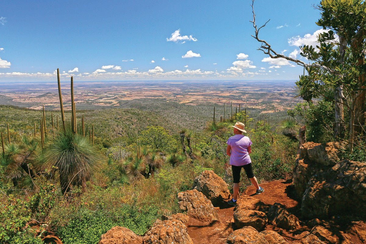
Tracks on the western side of the mountains lead to lookouts with breathtaking views over the Darling Downs. They all start from picnic areas on Bunya Mountains Road and can be walked as short return loops or connected to form a longer hike that follows the cliff-line through a variety of scrub and forest to each of the lookouts. A 2.3km track winds steadily around Mt Kiangarow, the highest peak in the Bunya Mountains (1135m) and approaches its summit through an avenue of 5m grasstrees, some of them several hundred years old.
To get the most out of the Bunya Mountains, you’ll need to spend a few days in the park to fully explore its many attractions, and visitors are spoilt for choice when it comes to overnight accommodation. The national park offers unpowered camping with good amenities at the grassy Dandabah camping area, suitable for RVs, and tent camping at Westcott and Burtons Well camping areas, with toilets, picnic tables and wood barbecues. There is also a wide range of privately-owned accommodation that includes motel-style rooms, B&Bs, cabins and chalets catering to couples, families and large groups. The small village adjacent to the ranger station at Dandabah contains a restaurant, cafe, art and craft gallery, and a small general store.
"ROAD UNSUITABLE FOR CARAVANS" SIGNS
The roads accessing the Bunya Mountains are steep and winding. Large signs warn of this in the foothills before ascents and at the top for descents and advise the routes are not suitable for caravans and trailers. These signs were erected by the Qld Department of Transport and Main Roads (TMR) in accordance with Austroads Safety and Design Guidelines, which recommend their use on roads of such steep gradients.
This presents something of a conundrum because official QPWS information says that the national park’s main camping area at Dandabah can accommodate RVs. On our last visit there in spring 2020 we found the camping area well patronised by rigs of all shapes and sizes. The resident QPWS ranger told us he was not aware of any breakdowns or accidents during his five-year stint there.
So why the signs? And where do you stand if you ignore them? The answer lies in transport laws that distinguish between ‘regulatory’ signs, on the one hand, and ‘road warning’ and ‘traffic instruction’ signs, on the other. (These signs and applicable laws are fairly uniform across Australian States and Territories.)
Regulatory signs inform you of traffic laws and regulations. They tell you what you, as a road user, must do by law in different situations. You must obey all regulatory signs or risk getting a fine and points deducted from your licence.
Road warning signs let you know road changes are coming up, such as narrowing of the road, changes in the road direction, or steep descent, crest or incline. They are there to warn that you should drive with caution according to the changed conditions.
Traffic instruction signs give you more information about the road you are travelling on. This information can include clearance of structures over the road, vehicle load limits, flooding depth indicators, or the suitability of some vehicles for the gradient. The signs on Bunya Mountain fall into this category.
Ignoring a warning or instruction sign may not get you a fine or points deduction, but could have other, serious consequences. Towing up steep inclines can put a lot of strain on the tow vehicle, especially one mismatched for the load. This can cause overheating of the engine, diff or drive train that can lead to failure or other damage. Likewise, steep descents need to be carefully controlled and excessive use can cause brakes to overheat and fail, with disastrous consequences.
The TMR undertakes regular road signage audits of the state-controlled road network to ensure appropriate signs are installed and/or removed as required. The Bunya Mountains road signs will be reviewed at the next Traffic Advisory Committee meeting between TMR, Queensland Police Service and Western Down Regional Council in January 2021.
Whatever the outcome, always drive carefully within your abilities and the capacity of your vehicle. If a sign tells you a road is not suitable for caravans or trailers, use your discretion and, if in doubt, err on the side of caution by taking a different route.
FAST FACTS
- Bunya Mountains National Park is 200km north-west of Brisbane, and about mid-way between Dalby (63km) and Kingaroy (58km) on the sealed Bunya Mountains Road.
- All access roads are steep, winding and narrow, and not considered suitable for long and/or heavy vehicles. Discretion is urged with respect to RVs and buses.
- The Bunya Mountains are a year-round destination, with a cool climate and low humidity. Winter mornings can be frosty and heavy fog and mists may occur at any time of year. Bring warm clothing, even in summer.
- Fuel is not available in the national park but can be obtained with most supplies at nearby Bell, Kumbia, Maidenwell and Kingaroy.
- Unpowered camping is available at Dandabah in a large open area suitable for tents, caravans, camper trailers, campervans and motorhomes. Facilities include picnic shelters, electric barbecues, flush toilets and showers.
- Westcott and Burtons Well camping areas are suitable only for tents, with toilets, picnic tables and wood barbecues (firewood supplied). Burton's Well has bush ‘boil your own water’ showers.
- Camping permits are required, and fees apply. Bookings can be made online at qld.gov.au/recreation/activities/camping/bookings.
- Privately-run cabins, chalets and guesthouses are available for rent at Dandabah. For bookings contact the Bunya Mountains Accommodation Centre.
QUEENSLAND NATIONAL PARKS
Bunya Mountains Office
57 Bunya Avenue, Dandabah
P: (07) 4668 3127
W: parks.des.qld.gov.au/parks/bunya-mountains
BUNYA MOUNTAINS ACCOMMODATION CENTRE
Bunya Ave, Dandabah
P: (07) 4668 3126
W: bunyamountains.com.au
SOUTH BURNETT VISITOR INFORMATION
P: (07) 4189 9172
W: tourism.southburnett.com.au
DALBY VISITOR INFORMATION CENTRE
E: dalby.vic@wdrc.qld.gov.au
P: 1300 268 624
W: westerndownsqueensland.com.au


