
At the Crossroads
At the heart of south-central Queensland, 680km west of Brisbane, Charleville is the largest town and administrative centre for the Murweh Shire, which covers almost 44,000 square kilometres. The town straddles the junction of four major roads, including the Mitchell and Warrego Highways, which radiate to the cardinal points of the compass, making it an important waypoint for travellers to and from the vast expanses of western Queensland.
Blessed with rich pastoral land, the shire’s main industries are grazing of beef cattle and sheep for wool production, while associated retail and service activities provide employment for the majority of the town’s 3300 residents. Tourism also makes a significant contribution to the regional economy, with popular attractions in the town and several national parks in the ranges to the north and in lush wetlands to the south.
The town also provides vital long-distance health and education services to remote stations and communities as far afield as Birdsville, 900km to the west. Charleville’s airport is the largest Royal Flying Doctor Service base in southern Queensland, while the School of Distance Education and the School of the Air provide postal, telephone and Internet services to children without primary and secondary schools in outback locations.
THE WARREGO RIVER
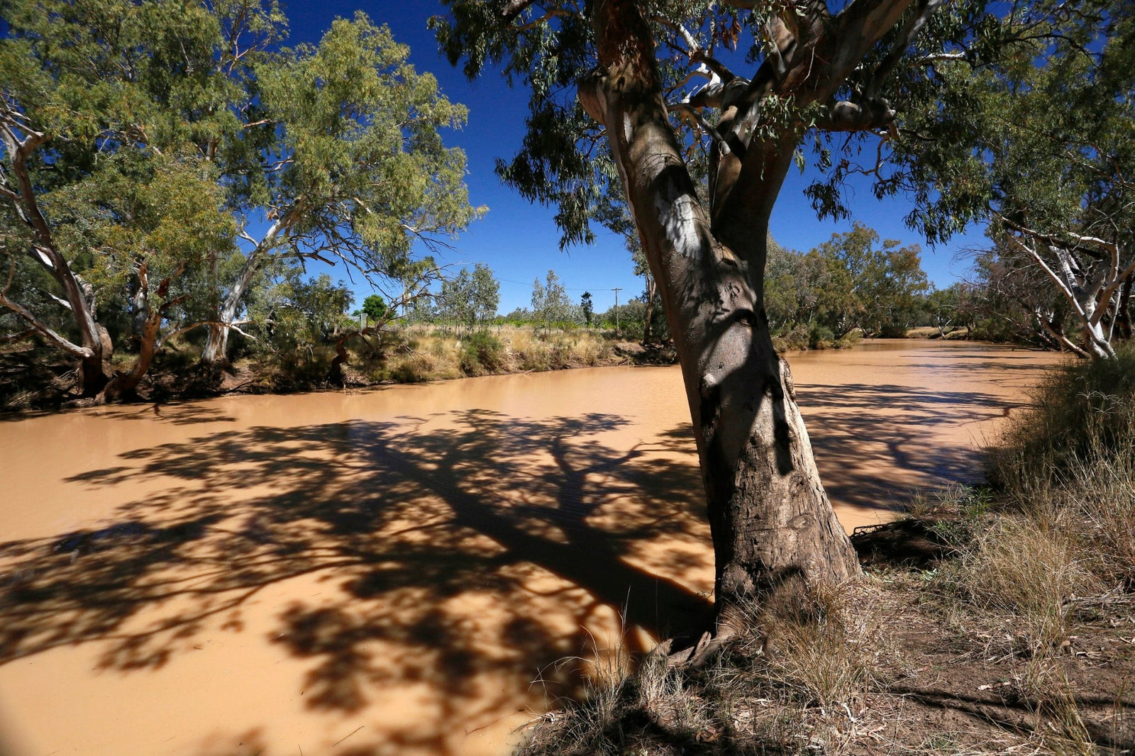
Charleville stands on the east bank of the Warrego, or ‘river of sand’ in the local Indigenous language. The river begins near Mount Ka Ka Mundi in the Carnarvon Range, north-east of the town, and is joined by 37 tributaries as it flows generally south for about 1380km before petering out in swamps downstream from Bourke, NSW.
Although the catchment is a huge 69,000sqkm, it’s largely comprised of hot, semi-arid plains in which annual rainfall is less than 400mm and very erratic. As a result, the Warrego is ephemeral and flows intermittently. Some years pass without any flow, and the river is reduced to a chain of permanent waterholes, like those 50km south of Charleville, which provide vital habitats for a wide range of aquatic fauna and significant waterbird populations.
However, deep monsoon troughs and the remnants of tropical cyclones, typically associated with La Niña, can dump copious rain across the upper catchment which causes severe flooding along the river. In April 1990, Charleville was devastated by floodwaters that peaked at 8.54m, inundating 1000 homes and forcing the evacuation of almost 3000 people. After further severe floods in 1997 and 2008, a levee was raised to protect the town and, when this was nearly overtopped by a flood in 2012, a new levee system and diversion of a local creek (Bradley’s Gully) were constructed at a cost of $14 million.
THE MULGA LANDS
Charleville lies at the northern edge of the Mulga Lands, a bioregion sprawling more than 250,000sqkm across south-west Queensland and northern New South Wales. This vast semi-arid expanse is a mosaic of flat sandy plains, undulating dunefields, ranges of long low hills, and alluvial floodplains. The plains and low ranges are dominated by woodlands of drought-tolerant mulga (Acacia aneura). Native grasses cover clay soils, with saltbush shrubland on less fertile red earths. The riverbanks, drainage channels and floodplains support red gum, coolibah, cypress pine and gidgee. These diverse plant communities provide habitats for an array of wildlife species that includes 256 birds, 56 mammals, 94 reptiles and 23 amphibians. The Warrego is one of the few rivers in the Murray–Darling Basin where silver perch breed naturally, and anglers will also find Yellow Belly, Golden Perch and Murray Cod.
FIRST NATIONS
Indigenous people of many nations lived in the Warrego catchment for more than 25,000 years before the arrival of Europeans. The Bidjara people are the Traditional Owners of the area around Charleville, and the towns of Augathella and Blackall to the north. The Warrego was an integral part of their daily lives, and still has great cultural and spiritual significance for their present-day descendants.
EXPLORATION AND SETTLEMENT
Thomas Mitchell was the first European to pass through the region, in 1846, while searching for a route to the Gulf of Carpentaria. He was followed a year later by Edmund Kennedy, who explored the Warrego catchment and established that the waterways in central Queensland, flowed south into the Channel Country rather than north to the Gulf.
In 1861–62, William Landsborough led an expedition to search for the missing explorers Burke and Wills. From a depot on the Gulf at Albert River, Landsborough’s party travelled south-east striking the upper reaches of the Warrego in early May 1862. They followed the Warrego to the Darling and eventually reached Melbourne in October, successfully completing the first north-south crossing of the continent. Landsborough left a trail of blazed trees at camps from the Gulf to present-day Cunnamulla to mark a route for driving livestock overland to north-western Queensland. One of only two blazed trees that have survived is at Camp 67 (10 May 1862) at Bakers Bend off the Mitchell Highway, 29km south of Charleville.
Landsborough's reports about the promising pastoral country he had encountered during his expedition drew settlers to the Warrego plains which proved ideal for sheep grazing. Initially, settlement was restricted to the river corridor for ready access to water, but the opening of artesian bores enabled graziers to spread further afield. One of the earliest stations in the Charleville area was the ‘Gowrie’ run, established in 1863 at a permanent waterhole where a stock route crossed the river at a ford on the northern outskirts of the present town site.
The Gowrie Crossing soon became a drovers’ camp and the focus of later settlement, with a town reserve gazetted in 1865 where a pub and general store already stood. Three years later, Government surveyor William Alcock Tully laid out the streets of the new town, which he named Charleville after his boyhood home in County Cork, Ireland.
As the wool industry prospered in the surrounding districts, Charleville grew to prominence as an important service town and link to the railhead at Roma and the paddle steamers on the Darling River. For 20 years, as many as 500 bullock teams passed through the town each year carrying wool bales for delivery to city markets. (The town had very wide streets to enable bullock teams to turn with their wagons.)
THE BUSH METROPOLIS
In 1876, Cobb & Co established a depot in Charleville and commenced regular services to Roma and Cunnamulla. Ten years later, the company moved its coach building factory (the largest in Australia) from Bathurst to Charleville because, unlike southern timber, the local wood used to make the coaches did not split and crack in the dry, dusty conditions of western Queensland.
This was the first of several industries that underpinned Charleville’s development as an autonomous bush metropolis. Another was the railway, which reached the town in 1888, making Charleville the terminus of the western line and provincial railhead for 10 years, until it was extended to Cunnamulla.
As the Cobb & Co factory was closing down in 1920, Charleville’s role in the age of flight was about to begin. On 2 November 1922, Qantas’ first regular mail run took off from Charleville bound for Cloncurry via Longreach and Winton, with passenger services beginning soon after. The town was also one of the compulsory stop-over check points during the London to Melbourne MacRobertson Air Race in 1934.
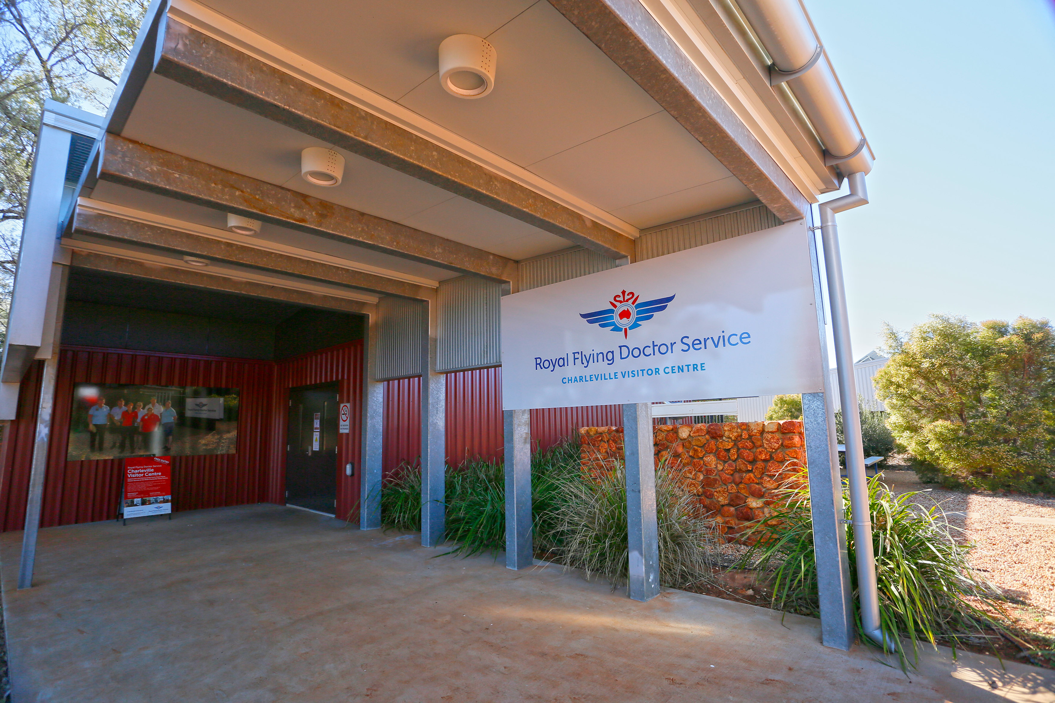
In early 1942, Charleville’s civil aerodrome was upgraded and enlarged to 25sqkm to accommodate Australian and US military aircraft, which used it as a base until the end of WWII. During that time up to 3500 USAAF personnel were stationed here. An aura of ‘Top Secrecy’ enshrouded the base while it was being used to develop and test the famous Nordon bomb sight, which proved a pivotal asset for the Allies in the war. The remnants of the military base and a new purpose-built information centre at the airport are popular attractions for visitors.
Also in 1943, the airport became a Royal Flying Doctor base for southern Queensland and its visitor centre tells the RFDS story through a combination of video and displays which highlight the complexity of the operation and the equipment used.
VISITOR ATTRACTIONS
Today, visitors to Charleville are spoilt for choice in the array of unique and fascinating attractions to entertain all ages and interests.
History buffs will enjoy the World War II Secret Base at the airport and the walking trail that takes in several elegant heritage-listed buildings around the town. One of the best of these is the former Queensland National Bank (1888), which now houses the Charleville Historic Museum and its comprehensive collection of memorabilia celebrating the town’s early settlement and pastoral origins.
Another heritage building, and great place for accommodation and refreshment, is the remarkable Corones Hotel (1929), which has a full-block frontage and has retained many of its original timber fittings. In its relatively short history, the hotel has played host to local and international society, from wealthy local graziers to celebrities such as Amy Johnson, Gracie Fields, and the Duke and Duchess of Gloucester.
For stargazers, young and old, the Cosmos Centre and Observatory is the perfect place to experience the wonders of outback night skies through powerful Meade telescopes, unaffected by light pollution that occurs in city areas. The Cosmos Theatre also provides an excellent venue for learning about the solar system and the beautiful Milky Way. (The asteroid 13933 Charleville is named in the town's honour.)
The bilby is one of Australia’s most endangered marsupials. Once common across much of south-west Queensland and the arid interior, bilby populations were decimated by feral predators and competition with livestock. Charleville stands at the forefront of the animal’s rehabilitation with a sanctuary which runs a captive breeding program to repopulate colonies in regional national parks. The Bilby Centre located at the Charleville Railway Station (the Visitor Information Centre) provides the opportunity for up-close contact with these very cute critters, and the National Parks Research Station is worth a visit to learn more about the conservation program.
Skillful bush equestrian skills are on display at the annual Charleville Campdraft, one of the region's largest, and the Polocrosse Carnival, while there are thrills and spills aplenty as competitors vie for prizemoney at the Charleville Bull & Bronc Rodeo.
CHARLEVILLE CONTACTS
Murweh Shire Council
95–101 Alfred Street, Charleville
P: (07) 4656 8355
W: murweh.qld.gov.au/tourist-information.
Bailey Bar Caravan Park
196 King Street, Charleville
P: (07) 4654 1744
E: baileybar@bigpond.com
W: charlevillebaileybar.com.au
Charleville Bush Caravan Park
P: 0428 545 200
Lot 1 Frawley Street, Charleville
E: info@travelwest.com.au
W: charlevillecaravanpark.com.au
Cobb & Co Caravan Park
1 Ridgeway St, Charleville
P: (07) 4654 1053
E: john@caravanparkscharleville.com.au
W: caravanparkscharleville.com.au


