
Memories to Keep
Keep River National Park is small by territory standards — only 574 square kilometres, less than 3 per cent of the size of Kakadu — but it stands tall among the best in the Top End for its spectacular landscape, Indigenous rock art, and abundance of unique wildlife.
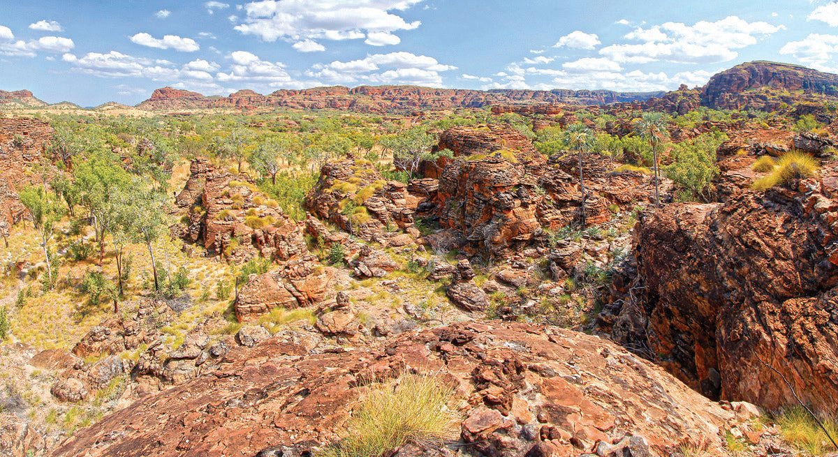
This is an ancient land, with its long and complex geological history reflected in a broad spectrum of diverse landforms and rock types. Most of the park is covered by undulating alluvial plains interspersed with dissected plateaus and exfoliated domes rising over 300m above the surrounding savannah. The park’s strikingly beautiful sandstone structures are composed of fine-grained sediments and ‘pudding stone’ conglomerate deposited in layers about 360 million years ago on the bed of a sea that once covered much of the East Kimberley region. Tectonic forces later lifted and tilted the richly-coloured rock and exposed it to weathering which sculpted ‘beehive’ formations with crevices, caves, and overhangs.
These are the tribal lands of the Miriwoong and Gadjerrong Aboriginal people, who have lived in the region for at least 40,000 years. The Federal Court of Australia has recognised their traditional ownership by granting native title rights over nearly 14,000 square kilometres of land, including Kununurra, Lake Argyle, the Keep River, and the Ord River Irrigation Scheme.
Evidence of Indigenous presence still remains in some 2500 stencils and drawings in rock shelters and caverns throughout the park. One of these is accessed on the Jenemoom Walk, a 3km meander along the bed of the Keep River in a shallow gorge to a site once used by Miriwoong people as a wet season shelter. As well as rock paintings, the shelter contains a midden with the remains of many meals. Another art site is located in an overhang at Lang-gerrbi, or Nigli Gap, on the Jarnem Loop Walk.
Alexander Forrest led the first colonial exploration to the region in 1879 in search of grazing land and natural resources. Within five years, pioneers had introduced vast numbers of sheep and cattle to establish a pastoral industry that continues today.
The park takes its name from the Keep River, whose headwaters are found in the sprawling black soil plains and stony ridges of Newry Station, which itself lies south of the Victoria Highway. First taken up in 1886, the Newry pastoral lease was part of the Durack cattle empire until 1950.
From here, the river meanders northward for 260km, traversing the park and criss-crossing the WA/NT border to its estuary on the Joseph Bonaparte Gulf. It is then expelled from the latter into the Timor Sea.
The region basks in a tropical monsoon climate that delivers about 800mm of rainfall annually, mostly during a wet season spanning December to March. While the rains last, the river carries some 500 gigalitres of water to the Gulf — approximately enough to fill Sydney Harbour.
Although this is a mere fraction of nearby Lake Argyle’s 10,500 gigalitre capacity, the Keep sustains a profusion of paperbarks, bauhinias, and pandanus along the riparian margins and lush grasslands that cross sandy floodplains. Here cane grass — a variety of sorghum that reaches more than 2m high — flourishes. Cane grass and other native grasses are essential to the survival of the endangered Gouldian Finch within a declared 'Important Bird Area' that covers much of Newry Station and the national park.
The river’s lower reaches and estuary are a complex maze of tide-dominated channels and wetlands forested by mangroves that provide habitats for breeding colonies of waterfowl and roosting sites for migratory shorebirds. Its pristine waters are populated by numerous species of fish such as barramundi, mullet, grunter, and sawfish.
In the dry season, the tropical sun bakes the savannah plains, reducing the river to just a trickle between semi-permanent waterholes and rendering streams a stony memory in the semi-arid landscape. Even then, uniquely adapted vegetation defies challenges posed by the harsh elements.
On the gently undulating plains are open woodlands of distinctive white-trunked bloodwoods alongside Darwin woollybutts bearing bursts of bright orange flowers. There are also ironwoods that were utilised by Indigenous people for making spears and clap sticks. A dark gum — made from the roots of the ironwood tree — was used as an adhesive for attaching spearheads to their shafts.
On the lower slopes of rocky outcrops grow dense stands of banksia, silver-leafed grevillea, and pindan wattle, which has modified leaves — or phyllodes — that reduce loss of water from the plant during dry seasons. Among these, evergreen Tristania trees provide splashes of colour with their clusters of yellow flowers. Higher up, tall specimens of emu apple, or desert plum, provide welcome shade for wildlife, and its bark contains a sap utilised by Indigenous people to stun fish in rivers and streams.
The upper slopes are dotted with stunted tropical red box, a species that has evolved to extract nutrients and water from its environment. Its tiny brown fruits are the smallest gum nuts of all eucalypts. At their base, spinifex grows plentifully in huge spherical masses.
The cracks and crevices between the sandstone formations nurture micro-habitats that are cooler and wetter than the surrounds and provide fire protection. These contain a variety of plants such as rock figs, fan palms, and milkwoods, whose milky sap had uses as Indigenous ceremonial paints.
These diverse plant communities provide habitats for a rich assortment of native fauna that reflect a mix of tropical and desert species. Northern Territory Parks and Wildlife has issued an information sheet listing 70 kinds of birds that may be found in the national park, making it a haven for bird-watchers.
The park entrance is 3km east of the Northern Territory/Western Australian border along the Victoria Highway, from which a gravel road leads to all the main attractions. A short distance from the entrance is the ranger station and Information Centre beside Cockatoo Lagoon (Woorrilbem).
The water level of the lagoon varies markedly with the seasons but rarely dries up completely. In the wet season it is an aquatic spectacle, covered with colourful and exotic lilies, while in the dry season it provides a vital refuge for flocks of water birds and other fauna. Picnic facilities near the lagoon make it a great place to relax and watch the birdlife, but stay well clear of the water — it's also home to crocodiles.
About 3km beyond the ranger station is Ginger’s Hill, where a short trail through silver-leafed grevillea and pindan wattle leads to a curious little stone structure with a roof of sticks. Standing only 1m high and 1.5m wide, it is similar to many that were built by Indigenous people throughout north-west Australia as a structure from which birds of prey could be caught. Exactly how this was achieved is explained by interpretative signs at the site.
Heading deeper into the park, the next stop is the Gurrandalng campground. The area takes its name from a Miriwoong Dreaming Story which tells of two Indigenous people that travelled to this site from the sea. On their journey grasses and bushes were collected, out of which they made a large nest and began jumping around it and making noises like a Gurrandalng, or brolga. As they danced, they were transformed into these stately and wonderful birds.
This pleasant campground is set among bloodwoods, woollybutts, and ironwoods which provide shelter and shade for campers. From here, the 2km Gurrandalng Walk heads off on a marked loop track — best done in an anti-clockwise direction — through spinifex and eucalypt woodland dotted with fan palms.
As the trail weaves between colourful rock formations in a rugged and dissected terrain, interpretive signs provide travellers with information about the sandstone habitats and introduce some of the flora and fauna that populate them. You may encounter some of these denizens, like white-quilled rock pigeons, and shy short-eared rock wallabies. The trail eventually emerges on an elevated rock escarpment backed by towering orange and ochre cliffs hosting a magnificent view of the Keep River landscape. Here, walkers gaze down upon a 'lost city' of beehive domes and beyond the wooded savannah plain to a line of distant ridges.
Passing the turn-off to the Jenemoom Walk, the park road continues to its terminus at the Jarnem campground in an open woodland setting that echoes the song of myriad birds. A short distance away, in clear view of the sites, a weathered sandstone knoll — which happens to be a registered sacred site — changes colour with each passing hour between dawn to dusk.
The camp is the head of the trail for three primary walks into the surrounding landscape. The 4.6km return Lookout Walk follows a natural creek line alongside a range of bare rock ramparts before climbing steeply through a saddle to a lookout with spectacular 360-degree views of the forested plains and the Jarnem escarpment. From here, walkers can retrace their steps back to camp or continue on a 6.5km loop via Lang-gerrbi, or Nigli Gap, and its art site. Again, an abundance of signs provide helpful explanations of the changing geology and native flora and fauna.
This part of the trail follows an intermittent watercourse beside the Jarnem range past deep, shadowy ravines throughout which enormous boulders are scattered. Among these, fan palms reach for the sky on smooth, arrow-straight trunks. After the gallery of ancient artwork, the track leaves the escarpment to meander across a grassy black soil floodplain back to camp. Lang-gerrbi can be accessed more directly on a separate 6km return walk from the campground without having to do the entire loop.
FAST FACTS
NEED TO KNOW: The entrance to Keep River NP is off the Victoria Highway 50km east of Kununurra in Western Australia, and 468km west of Katherine in the Northern Territory.
Unsealed gravel roads within the park are suitable for 2WD vehicles, caravans, and camper trailers in dry conditions but may be closed due to flooding during the wet season, which is usually November–April. Kununurra is the nearest town for fuel and supplies.
VISIT: The best time to visit is between May and August, when temperatures range between 10–35 degrees.
STAY: There are two camping areas: Goorrandalng, and Jarnem, 18km and 32km respectively from the park entrance. Facilities include tables, wood-fired barbecues, and composting toilets. Limited drinking water is available at Jarnem, and along the road just past the Ranger Station turn-off. Camping fees are payable on-site.
HIGHLIGHTS:
- Spectacular sandstone formations
- Scenic savannah bushland
- Indigenous rock art
- Abundant birdlife
CONTACT:
NT Parks & Wildlife Commission
32 Giles St, Katherine
Ph: (08) 8973 888 (Katherine); (08) 9167 8827 (Keep River)
W: parksandwildlife.nt.gov.au/parks
Katherine Visitor Centre
Ph: (08) 8972 2650
W: visitkatherine.com.au
Kununurra Visitor Centre
Ph: (08) 9168 1177
W: visitkununurra.com


